Earth’s rigid lithosphere, composed of Earth’s crust and the upper most mantle, is broken into many large pieces called tectonic plates. Over long periods of time, these plates are moved (only very small amounts annually) around the surface of the planet. This motion is driven by density differences in Earth’s less rigid mantle. As the plates move about they are constantly interacting with one another in a variety of ways. Depending on the type of interaction and the density of the crust, these interactions can result in the formation of large-scale features, such as mountains and deep ocean trenches or they can cause more abrupt and catastrophic effects, such as earthquakes and volcanism.
We can tell from two different lines of evidence—geodetic and geologic—that the lithospheric plates move. Even better, we can trace those movements back in geologic time.
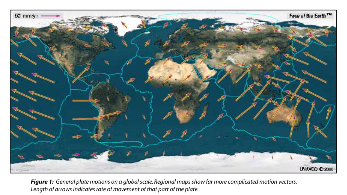
Geodesy, which is the science of measuring the Earth's shape and positions on it, lets us measure plate motions directly using GPS, the Global Positioning System. This network of satellites is more stable than the Earth's surface, so when a whole continent moves somewhere at a few centimeters per year, GPS can tell. The longer we do this, the better the accuracy, and in much of the world the numbers are quite precise by now.
Another thing GPS can show us is tectonic movements within plates. One assumption behind plate tectonics is that the lithosphere is rigid, and indeed that is still a sound and useful assumption. But parts of the plates are soft in comparison, like the western American mountain belts. GPS data helps us separate blocks that move independently, even if only a few millimeters per year. In the United States, the Sierra Nevada and Baja California microplates have been distinguished this way. Indiana is located on the North American tectonic plate and is not currently near a plate boundary. In fact, Indiana is about as far as you can get from any plate boundary – the nearest ones are at the California coast, the mid-Atlantic, and the Gulf of Mexico. Currently, the North American plate moves about 1 to 2 cm per year - a VERY slow rate but one that can be recorded with technology like CORS.
Continuously Operating Reference Stations (CORS)
The posted coordinates will bring you to a Continuously Operating Reference Station (CORS) you will visit as part of this earthcache. The station can be see just off the walking path. No need to cross the nearby fence.

CORS are permanent Global Navigation Satellite System receivers, antennae, and support equipment that provide highly accurate and precise real-time vertical and horizontal positioning data that can be used by geologists, meteorologists, surveyors, atmospheric scientists and others to calibrate their instruments. In short, CORS are super-benchmarks! They represent a major technological advance in global positioning technology, and, like many technological advances before them, they are providing a wealth of data about plate tectonics. To learn more about how geoscientists use CORS data to study plate movements out west, you should visit the EarthScope Plate Boundary Observatory website.
CORS has already made an impact on solid Earth science and is on the fringe of significantly impacting atmospheric science. CORS stations have many uses such as crustal motions, changes in sea levels, and tropospheric and inospheric studies.
Crustal motion monitoring is perhaps one of the most obvious of all CORS applications. If CORS data are rigorously processed and analyzed during a period of several years, then the motion of the Earth’s crust can be determined wherever the CORS network provides sufficient coverage.
The variations of vertical crustal velocities at CORS sites near tide gauge stations may be used to determine the “absolute” sea level change with respect to the International Terrestrial Reference Frame. This type of analysis was impossible to conduct before the abundance of CORS in coastal areas. After calibrating historical tidal data with these derived crustal velocities, the results show that the mean rate of absolute sea level change equals 1.80 +/- 0.18 mm/year.
To log this earthcache you must visit the CORS station, answer the following questions, and send the answer to me via email using my geocaching.com email account.
1) What is the approximate size (height) of the CORS station at the posted coordinates?
2) Describe the station's location relative to the surroundings. Why do you think it is located here and attached in this way?
3) This CORS station is designated IUCO. Its National Geodetic Survey site log can be found here. Or or this link . Visit this site and tell me the date that this CORS station was installed.

4) Follow the short-term time series link on the website. Has the station shifted more or less than 5 cm over the period of time it has been installed? Based on what you know about the North American plate's average rate of plate movement, how can you explain the time-series data for this station?
5) Has the station shifted more vertically or horizontally in the time that it has been installed? What factors might explain this difference?
6) Compare the shift at this location over time with the change in sea level readings mentioned above. Which is more?
7) Post a picture of yourself (face not required) or a personal item at the CORS station.