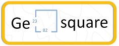
The Geosquare Series:-
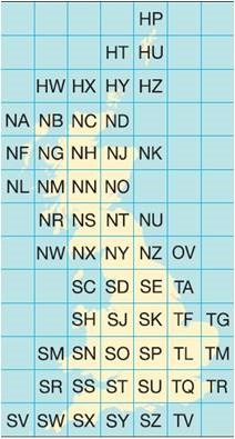
The Ordnance Survey (OS) National Grid provides a unique reference system, which can be seen on all Ordnance Survey maps of Great Britain. Great Britain is covered by 100 kilometre grid squares, each grid square is identified by two letters. On Ordnance Survey maps these squares are further divided into smaller 1 kilometre squares by grid lines representing 1 kilometre spacing, each numbered from 0 to 99 from the south-west corner, in an easterly (left to right) and northerly (upwards) direction.
In the Geosquare series the cache is named after the 1 kilometre square in which it is placed. Others are welcome to add to the series, using the logo, sidebar and description.
The Cache:-
The cache has been placed along a footpath which appears little used between the village of Middleton-on-Leven and Weary Bank. There is a limited amount of parking in Middleton-on-Leven but please be considerate. It may need some courage to push through the initial stages of the footpath but the effort is well worth while for the views.
On a clear day you will have a good view to the south stretching round from Roseberry Topping at the eastern end past Captain Cook's Monument to the full sweep of the Cleveland Hills including The Wainstones andd Cringle Moor. The view is particularly good on a summer evening with the sun highlighting the hills
