
A note of caution:
As you embark or continue your journey to discover and explore beautiful and historic rocks, waterfalls, peaks, creeks and other wonders, please keep in mind that these places need to remain wild and protected so that they may be enjoyed by others for generations to come. Please be diligent in respecting these sites by doing the following:
1. Please keep trash with you at all times, do not leave it behind in these pristine places.
2. Bury human waste 6 inches deep, make certain you are at least 50 paces away from any water source and PLEASE bring your toilet paper and sanitary items back out with you.
3. Keep food and all scented items on your person at all times.
4. Support wildlife by allowing them to find their own food, do not feed them.
5. Allow plants to grow and water to stay clean by staying on trails, bike paths and roads.
Thank you, Yosemite Wilderness Management


Tumbles and Talus.
In this Earthcache lesson, we will highlight the 1987 Middle Brother Rockfall and the talus remains that can be seen today. These coordinates take you up the Four-Mile Trail to a great lookout point where one can view the talus slopes to the north across the valley.

Enjoy the hike, be safe, and have fun!
The Rockfall:
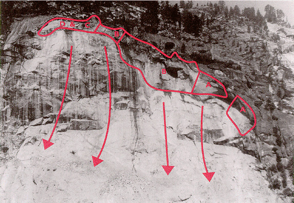
The Three Brothers are a set of three jagged peaks in Yosemite National Park. They are made up of granite. The middle one, appropriately named Middle Brother, has quite the stigma. It is known for being the most active rockfall site in the park. And this is evident as you can see the mounds of talus below. On March 10, 1987, Middle Brother had a massive rockfall, displacing nearly 1.5 million tons of rock.
1996 Happy Isles Rockfall Animation
The talus you see was caused by that catastrophic event that closed some campgrounds for quite some time.
Rockfalls and Talus:
Talus is another name for the rock debris caused by a rockfall. It is formed when chunks of rock fall away from the bedrock. Rockfalls can be caused by a number of ways. Triggering mechanisms like water, ice, earthquakes, and vegetation growth are among the final forces that cause unstable rocks to fall. We will focus on two processes that causes rockfalls in this earthcache lesson: frost wedging and degradation. Frost wedging is the process in which water fills cracks and crevices in the rock, and then freezes. This fluctuation in temperatures causing the water to freeze can break off chunks of the rock. Water expands by approximately 9% when frozen, so this widens cracks, and eventually pushes the rock away from the rest. It then plunges to the ground below. Another way rockfalls can occur is simply by the degradation of the rock bonds being to much for the cliff. It is not the weight of the rock that triggers it to fall, but rather the progressive degradation of the bonds (physical or chemical) that hold the rock in place. This degradation can occur from water, heat, or just sub-critical crack growth. But it is the degradation that is the trigger, not the weight of the rock. Some valleys that have been cut by glaciers (like Yosemite Valley) can be carved to steeply. When the ice has melted, the sheer cliff cannot support the weight of some rocks at the top, and the cliffs crumble from lack of support.


Once the rocks fall, they form talus slopes, which are the evidence of rockfalls you see today. Talus will continue to pile up to the angle of repose. The angle of repose is the steepest angle a rock pile or sand dune can achieve. The angle is determined by the size of rocks or grains. Naturally, larger chunks will have a higher angle of repose. Slopes with rocks less than one foot in size are referred to as scree slopes. In general, talus slopes can form at the base of mountains, cliffs, valleys, and even volcanoes!
Logging this cache:
Please e-mail with the following:
•The name of this Earthcache
•Number of people in your party
•Based off what you can see from this view, how much of the wall has been covered by talus? (All, 3/4, Half, 1/4, or None)
•Do you think the pile has reached it's angle of repose?
•How did you reach that conclusion?
Most importantly, have fun with this earthcache. Don't worry yourself too much about the answers if you have trouble viewing it or it is a cloudy day or something. After all, it's just a geocache.
Earthcache listing approved by Yosemite National Park.
With contributions to the the lesson made by Greg Stock, Yosemite National Park Geologist.
Sources:
--http://en.wikipedia.org/wiki/Scree
--http://www.geocaching.com/geocache/GC2M28R_merced-river-talus-slope?guid=896b17c4-34e7-4645-975e-ecbc9005cf82
--http://geology.campus.ad.csulb.edu/people/bperry/Mass%20Wasting/RockFallDiagramAfterS.GIF
--http://www.nps.gov/yose/naturescience/rockfall.htm
--http://www.nature.nps.gov/air/edu/someair/parks/yose/IIC2f.html