Indiana Benchmarking #190 :
Erosion on the Plains
Two of my favorite hobbies under the umbrella of Geocaching is Earthcaching and Benchmarking. At this azimuth we find the two worlds meeting to teach a valuable lesson concerning Earth science.
To accomplish the task of this Earthcache you will need:
A Tape Measure/Ruler
Review of historical surveyors notes on this Azimuth
Altimeter (GPS or Cell phone)
Your own conclusion based on the data you have collected and the facts presented.
Here on the Indiana Plains we see a clear and present sign of erosion, but what is erosion?
Erosion by definition is the exogenix process of removal of soil and rock from the crust of the Earth and then transported to another location either inches or miles away.
Types of Erosion:
A.) Rainfall: The process of rainfall erosion is a 4 stage process and are given in order of it's severity on soils:
1. ) Splash
2.) Sheet
3.) Rill
4.) Gully
Let's use definition and pictures to paint a better understanding of this process

Splash: The least severe, water falls from the sky and hits the soil at X rate causing a disbursement of soil upon impact and creating a crater where the rain has hit. The disbursement in light of the other three forms of rainfall erosion are minimal. A raindrop can project soil two feet high in the air to five feet horizontally on fairly level ground.

Sheet: As rainfalls and the soil has saturated water begins to rise and move. The moving of the water takes the deposition of soil with it and gathering other loose soil in it's flow.

Rill: Small flow paths in which sediment has been deposited and is a source for the delivery of the sediment. See picture for example.
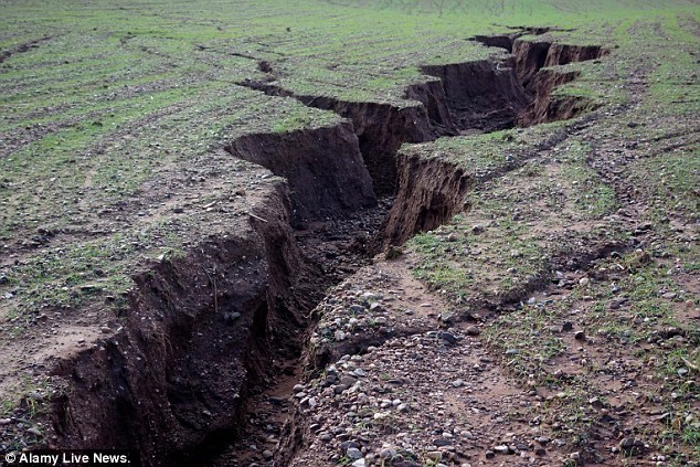
Gully: The most severe case of erosion is caused by rapid runoffs in narrow channels. Example causes of rapid runoffs could be abnormally high rainfall or quickly melted snow.
B.) Flooding: Flooding is a high accumulation of water that submerges land in an area which is usually dry. On the Indiana plains areal flooding can present itself when rainfall has rapidly over saturated the ground or nearby bodies of water have overflowed it's boundaries.
C.) Wind Erosion (Aeolian Process): There are two primary types of wind erosion
1.) Deflation
2.)Abrasion

Deflation is the transportation of loose particles as the wind blows.
Abrasion is the wearing down of surfaces as the wind carries loose particles and "sandblasts" them against other surfaces.
Probably the most famous occurrence of wind erosion in America would be known as the dust bowl. Although, wind erosion is a daily occurrence.
There are many other forms of erosion such as freezing and thawing to even lightning strikes. Many factors play apart on the ever changing geology of our planet.
Your goal today is to decide, what caused the erosion seen at this site.
Please email me the answers to the following questions. Please refrain from posting your answers your log.
Pictures are always welcome, but never required.
1.) Using the date stamped on the Azimuth, how many years has the erosion process been going on at this benchmark?
2.) Using the link provided here, visit the Azimuth's page and read the surveyor notes. At what height is the concrete post protruding from the ground at the date established in question 1?
3.) According to the surveyors notes, how many feet above the road is this azimuth set?
4.) A.) Using your ruler/measuring device, how much of the concrete post of the azimuth is exposed now?
B.) Can you see any discoloration in the concrete post from where the lands soil once was?
5.) Using your altimeter, Give me two elevation readings:
1.) The roadside
2.) The Azimuth.
Has there been a difference in elevation since it was noted by the surveyor?
6.) Based on the information gathered and presented, what type and/or types of erosion are in effect here?
Why have you come to your conclusion?
Thanks so much for visiting this Fayette County, Indiana Earthcache!
