The golf courses in this area, although not by the sea, resemble the older links golf courses in Scotland in that they are built on immense quantities of sand and gravel. These were deposited when the last ice sheet finally melted some 15,000 years ago, leaving long sinuous ridges of sand and gravel (eskers), flat-topped mounds (kames) and enclosed hollows (kettles) on the south-facing slope of the Muir of Ochil.
It is said that the golf courses were designed to utilise and enhance the natural features. The Heuch o’Dule glacial meltwater channel is a feature found between the King's and Queen's courses. Kame, esker and kettlehole geology can be seen on The King’s course.
Fluvio-glacial deposits
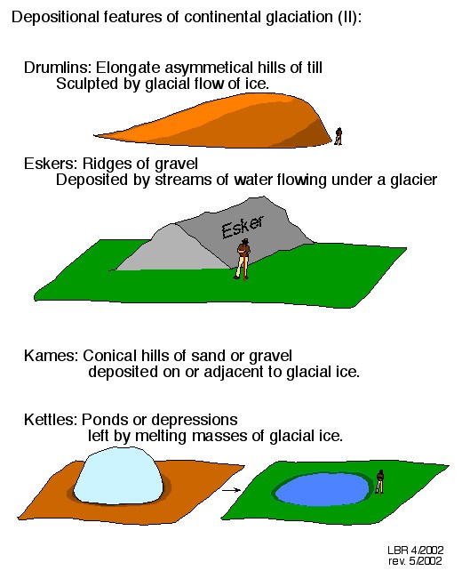
Fluvioglacial landforms are those that are created by the work of meltwater streams in front of an often retreating glacier. Glacial deposits tend to be unstratified (have no layers), unsorted and angular. These landforms include melt water channels, kames, eskers, and kettles.
Outwash plains are areas of sorted sand and gravel deposited at the mouth of meltwater rivers which were often braided. Kettle holes may be found if a block of 'dead ice' is partially buried by fluvio-glacial deposits. When the ice melts a 'hole' is left which may fill with water to form a kettle-hole lake.
Eskers are long, winding ridges of layered sand and gravel similar to railway embankments. They are formed inside the ice, in tunnels in which meltwater streams flowed. They may branch and are commonly discontinuous.
Kames are low mounds or hummocks composed of stratified sand and gravel. They are deposited by a subglacial stream as a fan or delta at the margin of a melting glacier.
Kame terraces are gentler slopes of layered sand and gravel at the side of valleys. They were formed at the edge of the glacier and valley side where meltwater forms on the surface.
Your tasks:
To log this cache, you will need to complete the tasks below. The co-ordinates take you to a place to park, but the tasks do not need to be done from here specifically. An alternative waypoint is also given, if you prefer. You are looking at the much wider landscape in which the golf courses are set. You will have to make some observations and explain what you see. Please message us with the info (rather than post it on your log). You can log a find as soon as you send us a message, but we may delete your log if your answer is way off the mark.
- Observe the area around you, in which the golf courses are set (not just at the parking co-ordinates). What makes this whole landscape ideal for a golf course? What natural features do you think have been utilised / enhanced for the golf course design?
- Look at the wider landscape around the golf courses and explain what you see from a geological point of view (eg eskers, kettles, kames etc). Is it flat, undulating, hilly, craggy, rocky etc. Can you explain what formed this landscape?
- As an optional extra, post a picture on your log of yourself and / or your GPSr with one of the golf courses in the background.