This Earthcache will bring you to the Dundas Peak Lookout. This lookout is located on the Southern side of Spencer Gorge. From here you have the opportunity to see the gorge in all it's Splendor.
Please use caution here! There are no railings, and you are at the edge of a sheer drop. Please keep a watchful eye and handhold on children and pets, a fall off the edge here would result in definite injury or possible death. Please be aware of these possible dangers.
A gorge is a narrow valley with steep, rocky walls located between hills or mountains. The term comes from the French word gorge, which means throat or neck. A gorge is often smaller than a canyon, although both words are used to describe deep narrow valleys with a stream or river running along their bottom. (education.nationalgeographic.com/education/encyclopedia/gorge/?ar_a=1)
Formation of a Gorge:
Erosion: the most common cause. Water erodes the rock as it flows along. Flooding speeds up this process. The water carries away the sediment downstream, and eventually over time, the steep walls of the gorge is formed.
Glacial Action: as glaciers move forward, they change the surface of our Earth. By scraping away softer rock, and leaving the harder rock, a deep valley of a gorge can be formed. As it retreats, the glacial meltwater is naturally diverted to the valley and helps with the gorge formation.
Geological Uplift: this is the Earth's upward motion, and we usually see it today in the form of an earthquake. During this process, softer rock layers are exposed and erode.
A gorge is generally formed from a combination of these processes.
Spencer Gorge
Before you is beautiful Spencer Gorge. It is Y shaped, and approximately 1 km long. Spencer Gorge was initially formed by the meltwaters of the Wisconsin Glacier. When the Glacier receded 12 000 years ago, the melt streams and waterfalls that resulted were much more powerful than present day, and formed the valley that you see below you. Water erosion continues to this day, through the work of the two waterfalls that are at the tips of the 'Y', but at a much more gradual pace.

Spencer Creek feeds Webster's Falls, which is at the other tip of the 'Y'.
Logie's Creek flows over Tew's Falls. There is evidence of at least 10 prior bowl-shaped basins within the Gorge, which show the earlier positions of Tew's waterfall. Some of the largest bowls indicate that this waterfall was once as large as Niagara Falls! Tew's Falls is the highest waterfall in the Hamilton region, and you can see the present bowl shape basin if you walk by.
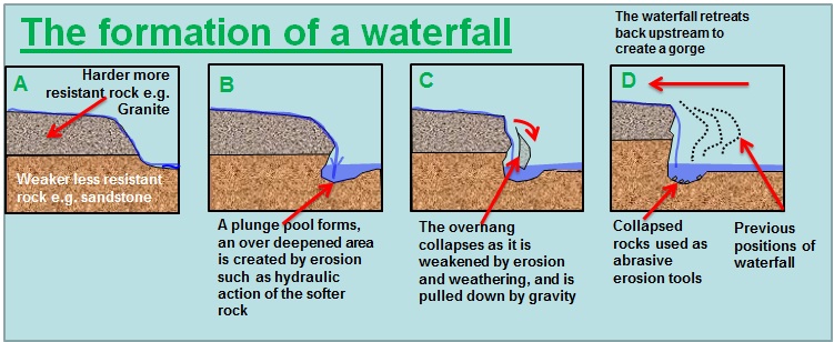
The water flowing over Tew's falls eventually erodes away or undermines the soft shale that is under the much harder Limestone cap rock. Eventually the Undermined Limestone breaks away, leaving a vertical bowl shape once again, and extending the gorge in the process.
Parking
I have Waypointed two choices of parking, one is free but involves quite a climb, along established trails, to get to Dundas Peak. The other is paid parking ($10.00), involves much less elevation change, and you get a view of Tew's Falls and an approximate 1km hike along the upper edge of the gorge. Depending on which you choose, here are the logging requirements:( personally, I recommend the free parking and still hiking over to Tew's Falls)
Logging Requirements
1) At Dundas Peak: email me your best guesses to the following Questions:
a)Based on the above readings, what kind of rock do you think you are standing on? Why do you think it was spared from the erosion that helped form the gorge?
b)Can you see where Spencer and Logie's Creek meet in the gorge, forming the 'Y"?
c)Let me know the number and letter that is carved into the cement at the top of the brick wall. THE BRICK WALL HAS BEEN REMOVED SO NO NEED TO TRY TO ANSWER THIS QUESTION.
2) if you came from 'free parking': take an elevation reading at parking. Then take an elevation reading at Dundas Peak. Email me your results. (This reading will give you the approximate distance in elevation of the gorge.)
3) if you came from 'paid parking'. I have Waypointed an educational sign on the Gorge. Send me the answer to this question: How many million years ago did the Niagara Escarpment begin?
Enjoy your visit!
This geocache is placed with permission of the Hamilton Conservation Authority. HCA Permit number 14-43
Resources:
http://education.nationalgeographic.com/education/encyclopedia/gorge/?ar_a=1#page=1
http://www.conservationhamilton.ca/Asset/iu_files/Spencer_G_Bro_2009_Page_2.pdf
http://www.ontariotrails.on.ca/trails/view/spencer-creek-gorge-and-the-old-dundas-station-loop
http://en.wikipedia.org/wiki/Spencer_Gorge/Webster%27s_Falls_Conservation_Area