This cache is an EarthCache, there is no physical container at the location. To claim a find, you will need to visit the location, answer the questions listed at the bottom of the page and send them to me. I will respond to you telling you whether you have the right answers or not. Hopefully, by completing this EarthCache you will learn a bit about the Cataract Gorge and claim a smiley as well. This is also Launceston's first EarthCache, what better place to start than the gorge?

The Cataract Gorge ("The Gorge") is a popular tourist attraction and is situated on the South Esk River, not too far from Launceston's CBD. Legend has it that the first basin is bottomless, but its real depth is estimated to be around 19 metres.
The first European to discover the Cataract Gorge was William Collins in 1804. A track around the Gorge was built in the 1890's by volunteers.
The chairlift was built in 1972, and its total span is 457 metres, which is the longest chairlift span in the world.
The original Alexandra Suspension Bridge was built in 1904 but was brought down by floods in 1929, along with the Duck Reach Bridge. The bridge was rebuilt in the following year, and in 2004 its cables were replaced.
When there are significant floods in Launceston, water roars down into the first basin, over the pool, sometimes submerging the entire lawn area, and in the June 2016 floods, the floodwaters almost reached the floor of the basin cafe!

The 2009 floods
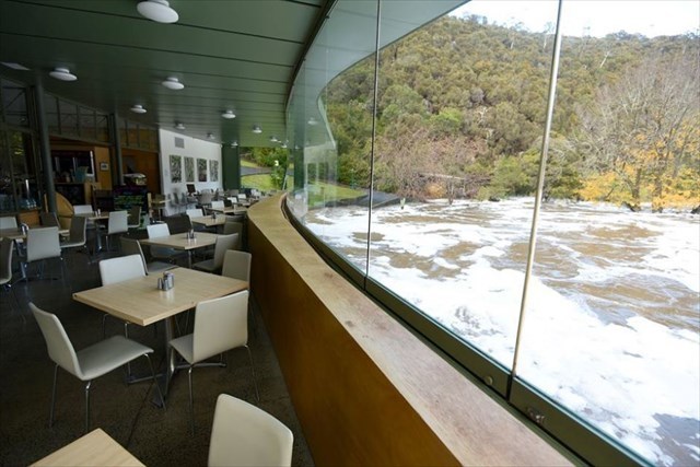
2016 floods from cafe
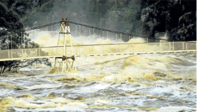
Suspension bridge during 2016 floods
How the gorge was made
When two fault lines caused by faulting met in the Jurassic period (145-200 mya), it made this amazing geological formation. Launceston's Cataract Gorge. Around 65 million years ago the Tamar River was created by faulting. This is when Australia, along with India separated from Antarctica. Where a major North - South fault met a minor East - West fault, the dolerite broke apart, so it eroded easily. This formed each of the basins. The first, second and third basins still exist but the fourth is under the Trevallyn Dam.
Before sea levels rose 20 thousand years ago, water didn't flow through the gorge. This is when Tasmania was still connected to the mainland.
The Gorge is made up of the rock dolerite, that dates back to the Jurassic age. The rock actually makes up about 40% of Tasmania (around 30,000km2). Dolerite is a type of igneous rock, which means it is formed in the earth's crust. Tasmania has the largest areas of dolerite in the world.
The other main types of rocks are sedimentary (like sandstone) and metamorphic (like slate).

Dolerite.

Rock type map of Tasmania. Red represents dolerite.
To complete this EarthCache, please send me a message with the answers to the following questions:
WP1
Q1: How wide is the ravine under the suspension bridge, before water flows into the First Basin?
The altitude of the surface of the water below the bridge is approximately 20 metres. The flood waters during the 2016 floods rose to just 2 metres below the suspension bridge.
Q2: How many metres above the usual water level did the flood waters rise to during these floods? (Use your GPS or estimate this height).
WP2
At WP2 you will see some large rocks a few metres from the seat on the lookout.
Q3: Name:
i. The rock that is present in this area and its type (metamorphic, igneous or sedimentary).
ii. The three colours of these rocks visible here.
iii. The two colours of the lichen on these rocks.
Other
Q4: What is the name of the river where the water flows before flowing into the first basin, and the estuary where it flows into?
Q5: Name another example of faulting in Tasmania.
Photos are of course welcome, just don't spoil any of the answers.
A few thing you should know:
Message these answers to me via my GC profile. Do not put answers in your log.
If you wish, you may log a find before I reply to keep finds in order, but you must complete and send the answers to me within a timely matter (2-3 weeks)
Please only share answers with cachers who were there with you to complete the EarthCache with you on the day
I may delete your log if:
You have put answers/spoilers in your log.
You have not sent the answers to me within timely matter (2-3 weeks) or you have not completed all of the answers.
Have fun at this amazing location!
Ref: Douglas Ewington, 28 October 2008 The Examiner, 2009, 2016.