This is an EarthCache, there is no physical cache to find, to log a find, visit the location and complete all the questions at the bottom of the page, and message the answers to me via my profile, I will respond to you saying if you have given me the right answers or not.
This EarthCache is about flooding and sedimentation. It is at the Royal Park/Seaport area, best visited at high tide when the silt isn't visible. The two signs at the two waypoints have the information you will need to complete this EarthCache.
The Tamar River is not technically a river, it is an estuary, this means the tide impacts the level of the water, but they are protected from the full force of the ocean, and are usually surrounded by reefs, barrier island, sand or mud.
Sedimentation is the word to describe the process of sediments gathering at the bottom of a fluid. In the Tamar River, sediments flow into the estuary, flocculate (clump together) and then flow further into the Tamar, increasing in size along the way. But when the tide recedes, there typically isn’t enough force to push enough of this silt out to Bass Strait, which is partially attributed to the existence of Trevallyn Dam, an operational hydroelectric power station 7km upstream in the South Esk River.
As for the silt itself, the source of much of it is from suboptimal land practices upstream such as forestry and agriculture. Dredging (physically transferring silt downstream) of the estuary has previously been undertaken as a method of reducing the silt build up, however, this doesn’t address the root cause of the problem.

Sedimentation in an estuary diagram.
Flooding: Flooding is defined as “the covering or submerging of normally dry land with a large amount of water” (Oxford Dictionary). The 1929 flood was the worst flood in Launceston on record, about 2,000 homes were inundated and 14-22 people died. The flood markers seen around Invermay show the level of this flood.
In June 2016, major floods lashed Tasmania resulting in three deaths and approximately $180 million in damages. Floodwaters at Royal Park reached as far as the top of the bottom step on the flood levee.
Flood mitigation:
In the mid-1960s, the flood levee that surrounds the North Esk River and Tamar Basin was constructed. While levees do, to a point, keep flood waters out of the area it surrounds, they raise other ethical dilemmas; the water that would have inundated one area is now funnelled through narrow walls further downstream at high velocity, leaving areas downstream more vulnerable to inundation. Levees can, however, be a key part of a flood management strategy, but they are far from stand-alone.
Flood intensity can be reduced by slowing the speed that flood waters reach down the catchment. Implementing several nature-based solutions such as restoring historical wetlands and creating ‘rain gardens’ instead of traditional stormwater runoff are key ways of doing this. Stormwater drains are designed to get rain off the streets and yards as fast as possible, but this unnatural system creates short bursts of high water flow which can worsen flash floods. These nature-based solutions are unfortunately relatively difficult to implement given how much of Launceston (or any given city) is covered by these non-permeable surfaces.
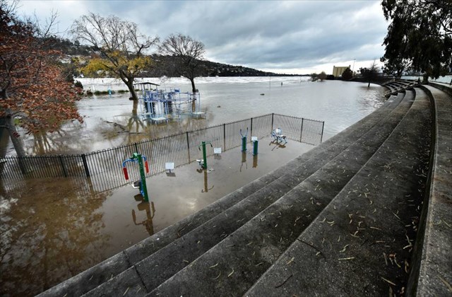
Flooding at Royal Park in June 2016.
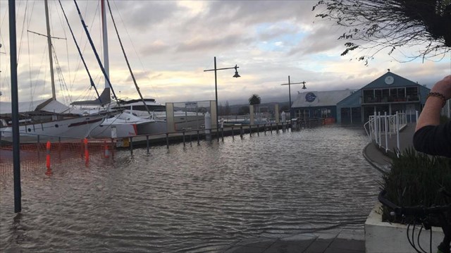
Flooding at the Seaport near WP2.

1929 Launceston floods.
Questions:
1. At the time of your visit, was the tide high or low, and was it on the way in or out?
2. Describe the turbidity (cloudiness) of the water at your visit.
3. (Sedimentation) according to the sign at WP1, up to how deep is the lower estuary?
4. (Sedimentation) on average, how many cubic metres of sediment is deposited in the Tamar each year? (see WP1)
5. (Flooding) in a 1-in-200 year flood, significant dredging would lower the flood level by about how many centimetres?
6. (Flooding) according to the sign at WP2, how may significant floods have occurred since records began?
7. (Optional) Photos you took at the location are most welcome.
A few things you should know:
Message these answers to me via my GC profile.
Do not put answers in your log.
I may delete your log if:
You have put answers/spoilers in your log.
You have not sent the answers to me within timely matter (2-3 weeks) or you have not completed all of the answers.
I hope you enjoy 'finding' this EarthCache!
Ref: QVMAG Douglas Ewington 2008, Damien McIntyre ABC News 2016, Australian Journal of Emergency Management 2022.