The Devils Bridge is an amazing part of The Worms Head which is a tidal island accessible 2.5 hours either side of low tide. The crossing and tide times are on display at the National trust shop, the coastguard station at the end of the headland and on the island. Please take note of these and DO NOT ATTEMPT this Earth cache at any other time. The walk to the cache site is very strenuous and uneven walking/clambering over rough rock. Please take into account the Terain rating!
Historically named 'Wurm' meaning 'dragon' by Viking invaders, Worm's Head, is shaped like a giant sea-serpent and marks the most westerly tip of Gower.
This cache is placed with the kind permission of The National Trust.
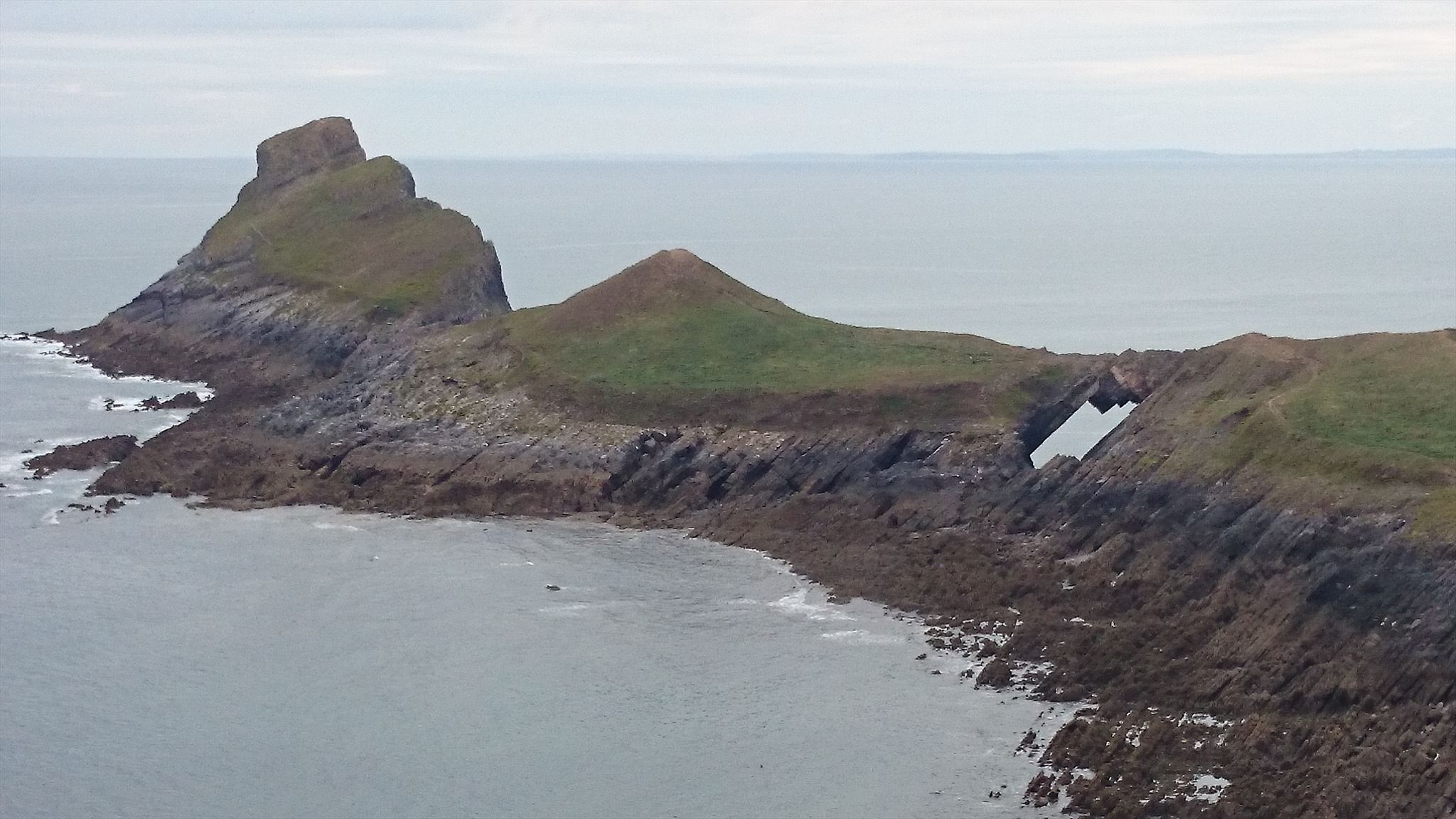
The island is joined to the mainland by a rocky causeway accessible at low tide and features a large flat-topped 'Inner Head', towards a natural rock bridge called 'Devil's Bridge', a 'Low Neck' leads further out to the 'Outer Head'. The headland is one mile long and the highest point is approximately 150 feet.
Parking is available in the village for approx £3-4, there are toilets a pub the church and gift/icecream shops. To get to the island pass the National trust shop (stop and check tide times!) then follow the path along the top of the cliffs. You should notice how level the land is, this is because it is an old beach level that has been raised up to a height of 200 feet since it was originally formed. This is a common feature around the south Gower cliffs.
The rocky, jagged causeway leading out to the 'Worm' is only exposed for two and a half hours either side of low tide, so always carefully check the tide times before setting off over the causeway. Being trapped on Worm's Head for half the day or overnight, waiting for low tide again, is so easily done if you lose track of time! Even the young Dylan Thomas made the mistake of falling asleep on the Inner Head and missing his tide:
"I stayed on that Worm from dusk to midnight, sitting on that top grass, frightened to go further in because of the rats and because of things I am ashamed to be frightened of. Then the tips of the reef began to poke out of the water and, perilously, I climbed along them to the shore." - Dylan Thomas.
At the tip of the headland you will find the old coastguard Lookout (stop and check tide times!)overlooking the sound (The Shipway) between the mainland and Worms Head. There is a definite geological reason why it has been eroded away by the sea and made Worms Head a tidal island. If you go down onto the rocks you will find a number of small faults in them running out to sea. They are filled with thick bands of white calcite which makes them easy to find. The way you can tell the mineral is calcite and not quartz is by scratching them with a two pence piece. If it were quartz it would wear into the coin as the mineral is harder than it, leaving a pencil type mark on the rock surface. As it is calcite a white powder is produced as the penny is harder than this mineral and can cut into it. Limestone can be dissolved chemically by water and is the only rock that is eroded this way. But as the water does so it quickly becomes saturated with limestone. In some conditions it can become supersaturated so that as it travels along fissures, such as those produced by faults, it leaves some of the mineral behind in the form of the very pure calcite. Iron and other trace minerals form red coloured bands in it. In the fault fissures here this calcite has completely filled the voids. The reason these faults are here is that they are minor side faults to a much larger fault that runs along the south Gower coast.
Keep to the right hand side of the Causeway to cross to the Worms Head. When you reach the island stop and check the tide times! You can then take the lower path to the left through the shrubbery but highly recommended for the view back to the bay is from the higher path! Crossing onto the Middle Head you are at once confronted by the Devils Bridge a dramatic angular crossing point between the sections of the island. To the south of this the rocky shore has been completely flattened by wave action, so creating the present wave cut platform. Towards the end of this middle section, to the right of the path, another truncated cave gives a window through which you can look along the north wall of the worm. Further access to the end of the worm is dictated by mother nature due to nesting birds please take note of any information provided.
If you get caught out by the returning tide under no circumstances should you try to swim back across as the tide becomes a huge river that will sweep you far out into Rossili Bay. Deaths have occurred to people attempting to do this.
Atlantic grey seals can be spotted usually sunbathing on the rocks below the northern cliff or "bottling" just off the coast where only their noses point out of the sea resembling a floating bottle!
Please ensure you have enough time to complete before you start!
To log this earth cache you must visit the island and answer the following questions.
1.At the site of devils bridge estimate the width of the bridge and the height above the sea.
2 describe the surface of the bridge in as much detail as possible,e.g. is it smooth or pointy, what colour rock is it, what is the rock made of, is it fine texture or coarse, are there plants growing on it?
3 Are there any fossils visible? If so describe them.
4 Suggest/research how the bridge was formed, and what might happen to it in its future?
5 state the time you left the mainland and the time you returned, ideally this should be captured as a screen shot on your phone as you cross the causeway or a photo of your GPS screen showing time and location
Send your answers to me via the message option or email via my profile. Don't forget to release your email address so I can reply. I may not reply to all emails so dont be offended if I dont get back to you it will mean your answers are correct! Failure to submit answers will result in your log being deleted
Not a logging requirement but Please post a Photo of the tide/crossing times displayed either on the island or at the coast guard station or in the National trust shop. Or a photo of you crossing the bridge - if your brave enough!
|
|
| I have earned GSA's highest level: |
 |

The Little Bridges series was started by Stanthews in 2009 to highlight small footbridges in remote parts of Wiltshire. Since then the series has been expanded by others all over the country and starting to spread fast, Damian from Winter Foxes has created and updates a list of cachers who has found 10 or more little bridges and can be found here, if you would like to add to the series, please contact Stan on stanthews@aol.com and he will give you a number for your bridge, to qualify, the bridge must be a foot bridge too small for vehicles, please make sure your title exactly matches “Little Bridges # xx then name” including spaces so it will get picked up and added to Damian’s list.
___________________________________________