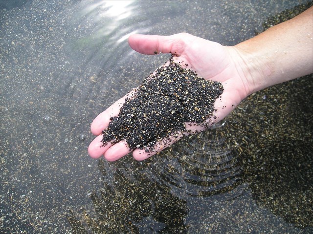
The Big Island of Hawaii is world famous for its black sand beaches. Many visitors make the long trip to the east side of the island to visit the black sand beaches at Punalu’u or Kehena. The Big Island, being relatively young compared to the other Hawaiian islands, has more black sand beaches than the other islands. However the life of a black sand beach is usually quite fleeting in geologic timespan. Once the flow of lava ceases there is no replenishment of the sand. The beach is then at the mercy of winds, currents and storms, the latter of which can cause a black sand beach to disappear overnight. Likewise new lava flows can completely cover old beaches, which is exactly what happened to the Kalapana Black Sand beach in 1990.
The Black Sand beaches of the Big Island are formed primarily through the flow of hot lava directly into the sea. The impact of the red hot lava onto the relatively cool seawater causes the lava to shatter into tiny lava grains.
So given the young age of the Big Island (~300,000 years old) and the preponderance of black basaltic lava on the island, where do the white sand beaches come from? The answer may surprise you. With the tropical climate of the island, coral reefs thrive around the island. While some natural erosion of the coral by water does occur, there is a much larger force at work that is converting the coral into sand. That force is bioerosion. One of the largest culprits of bioerosion on the big island are the myriad of parrotfishes that inhabit the reefs off the coast.
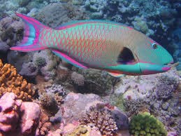
The parrotfish spends its day feeding on algae and coral polyps that form on the reef. The fish possess a beak-like mouth and you can literally hear the crunch as the fish bites down on the coral. The parrotfish cannot digest the coral, so the crushed coral passes through its digestive system and is excreted by the fish. Many of the coral grains deposited by the fish are washed ashore and form the white beaches on Hawaii. This behavior of the parrotfish is vital to the health of the reef, as without this constant cleaning of the coral, the algae would suffocate the reef and the coral would die. It is estimated that each adult parrotfish is responsible for the production of 100 kilograms of coral sand a year!
While inland sand is typically comprised of silica (usually in the form of quartz), coastal sands are usually comprised of calcium carbonate – as they are formed from eroded reefs. Geologists have developed two useful tools for classifying sand. One is through measurement of the grain size of the sand. The table below classifies the sand by the diameter of the grains measured in millimeters.

Another useful tool is the determination of the sphericity (a ball would be a perfect sphere) of the sand grains, as well as the sharpness, or angularity of the edges of the grain. This combination of characteristics has been assembled into a useful chart, first proposed by Wadell in 1932.

THE CACHE
This EarthCache will take you to three beaches located near Kekaha Kai State Park, which is located about 15 miles north of Kona on the west (yes, the west) side of the island. The first waypoint will take you to the white sand beach at Mahai’ula Bay. The third waypoint will take you to Makole’a Black Sand Beach. This beach was formed during the Hu’ehu’e Lava flow of the Hualalai Volcano in 1801. The second waypoint will take you to another nearby beach.
TO LOG THIS CACHE: >
- At each waypoint you will need to observe a sample of the sand and using your magnifying glass and ruler and the charts above, determine:
- the textural class of the grains you observe
- the sphericity and angularity of the grains you observe
Make readings on the smallest and largest sand grains in your sample at each location.
For example, a 1.5mm ball would be classified as Very Course Sand, with a High Sphericity and Well Rounded Angularity.
- Is there a difference in the sphericity or angularity between the largest and smallest grains in your samples? What do you think is the cause of this difference?
- Visit the Point of Interest Waypoint. Who is responsible for this structure?
You will need to email the results of your observations to us. Please list the waypoint numbers, along with the above information for each location. Logs without the accompanying email will be deleted. Please do not include the classification information in your logs, as they too, will be deleted.
Sure we’d love to have a photo of you at one of the beaches, but it is not required for logging the cache. Take all the pictures of the beaches you like, but please, no close up photos of the sand (i.e. spoilers).
A friendly reminder that it is illegal to remove sand from the beaches in Hawaii. Do NOT remove the sand for analysis later.
BIBLIOGRAPHY
Sedimentation Engineering – Vito Vanoni, American Society of Civil Engineers. Published 2006. ISBN: 0-7844-0823-8 Hawaii – The Big Island Revealed , 6th edition, A. Doughty, Wizard Publications ISBN 978-0-9814610-7 Sand Research Shaping Up – AGCSA – Retrieved August 18, 2014 from: http://www.agcsa.com.au/static/atm_articles/html/2_4f.html Desert Island Experiences – DOCASTAWAY Retrieved August 12, 2014 from: http://paradise.docastaway.com/white-sand-beaches-parrot-fish-poop-feaces/