This Artesian Well EarthCache is located in the Public Use Area below Grenada Dam. You will find it in the middle of a playground. Even though Muggles will be everywhere, stealth is not required.
The term “Artesian Well” is named for the former province of Artois, France, where many such wells were drilled by Carthusian monks since 1126. This technique was also known much earlier in ancient Syria and Egypt. It is unknown whether the monks of Artois learned of this technique from outside sources or developed it independently on their own.
An artesian well is a well that taps into a confined aquifer (see image below). Under artesian pressure, water in the well rises above the top of the aquifer, but does not necessarily reach the land surface. A flowing artesian well is one that has been drilled into an aquifer where the pressure within the aquifer forces the groundwater to rise above the land surface naturally without using a pump. Flowing artesian wells can flow on an intermittent or continuous basis and originate from aquifers occurring in either unconsolidated materials such as sand and gravels or bedrock, at depths ranging from a few meters to several thousand meters. All flowing wells are artesian, but not all artesian wells are flowing wells. 
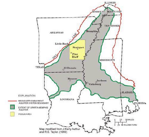
Artesian wells have been very important to man as he settled and developed this country, as they offered a reliable source of clean water for drinking and irrigation. The water is filtered after traveling through many miles of porous sand and rock, in a process that probably took many, many years to complete. This filtering removes most of the pollutants that plague most surface runoff waters today. The readily available clean drinking water not only helps give birth to towns and cities, but also to entire industries. The water of this spring comes from the Sparta Sand Aquifer. It consists of varying amounts of unconsolidated sand, inter-mixed with belts of silt and clay within the Sparta Sand of the Claiborne Group. It extends from south Texas, north into Louisiana, Arkansas, and Tennessee, and eastward into Mississippi and Alabama. This strata is exposed on the surface along the outside edges, and buried deeply beneath the surface along its southern edge and central axis, which roughly follows the Mississippi River.
To take credit and log this find, you must do the following:
1. Take a photo of yourself with your GPS, with the Artesian Well in the background. Post the photo with your log. (Optional)
2. Is this a "Flowing" or "Non-Flowing" Artesian Well? E-mail your answer to me via my contact link above.
Please do not post your answer to #2 with your log. I hope you learned something about Artesian wells today, and enjoyed this earthcache.