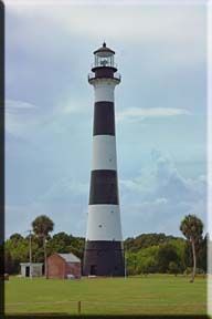
This lighthouse is a historic lighthouse on the east coast of the U.S. state of Florida. The light was established in 1848 to warn ships of the dangerous shoals that lie off its coast. It is located inside the an Air Force Station and managed by the 45th Space Wing of the U.S. Air Force with the assistance of the Lighthouse Foundation. It is the only fully operational lighthouse that is owned by the United States Air Force.
The current 151-foot (46 m) lighthouse tower was first erected and lit in 1868 then relocated further inland between 1893-1894. It was originally equipped with a first-order Fresnel lens that was automated in 1967 and then retired from the tower in 1993.
Year first constructed: 1848
Year first lit: 1868
Automated: 1960
Foundation: brick
Construction: cast iron plate with brick lining
Tower shape: conical
Markings / pattern: 1868: white
1873: black and white horizontal bands with white lantern room
1894: black and white horizontal bands with black lantern room
Height: 151 feet (46 m)
Focal height: 137 feet (42 m)
Original lens: first-order Fresnel lens
Current lens: DCB-224
Range: 1st order: 18 nautical miles (33 km; 21 mi)
Current: : 24 nautical miles (44 km; 28 mi)
Characteristic: 1st order: flashing white every minute - flash 5 secs, eclipse 55 secs
Current: Fl (2)W 20s
0.2s fl 4.8 secs.
0.2s fl 14.8 secs.
In order to get the correct coordinates, please choose which lighthouse this is:
A) Smith Shoal Lighthouse - N29° 21.078 W81° 46.986
B) Fort McRae Range Lighthouse - N29° 21.178 W81° 47.486
C) Cape Canaveral Lighthouse - N29° 20.428 W81° 48.039
To learn more about Florida Lighthouses, please visit the link below:
Lighthouse Friends, Florida Lighthouses: http://www.lighthousefriends.com/fl.html
Unless noted otherwise, all source material is from Wikipedia.