In the 1820s, the town of St. Marks, Florida was considered an important port of entry. The town served as a port for the prosperous planting region of Middle Florida and some counties of South Georgia. Growers hauled their agricultural products down to the port town in wagons by way of an early road which connected the then territorial capital of Tallahassee to the town of St. Marks. Later, this road would be widened and improved upon by the Tallahassee Railroad Company and would become the state's first railroad.
Once the agricultural products reached the new port town, they were loaded aboard boats for shipment to New Orleans and/or St. Augustine. There were, however, problems in navigating both the Apalachee Bay and the St. Marks River. In many places both bay and river were shallow, and it was not too uncommon for boats to run aground and/or get mired in the muddy shallows.
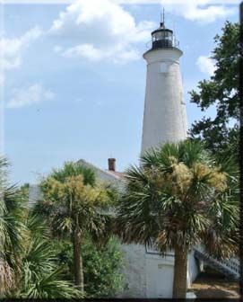
Location: mouth of St. Marks River, on Apalachee Bay, St. Marks, Florida
Year first lit: first tower, 1831; second tower, 1842
Automated: 1960
Foundation: stone
Construction: brick
Tower shape: conical tower
Height: originally 65 feet (20 m), extended to 73 feet (22 m) in 1867, light is 82 feet (25 m) above sea level
Original lens: fourth order Fresnel lens, replaced by 9.8-inch (250 mm) lens
In order to get the correct coordinates, please choose which lighthouse this is:
A) St. Marks Lighthouse - N29° 20.682 W81° 48.733
B) St. Johns River Lighthouse - N29° 21.668 W81° 47.186
C) St. Augustine Lighthouse - N29° 21.378 W81° 47.386
To learn more about Florida Lighthouses, please visit the link below:
Lighthouse Friends, Florida Lighthouses: http://www.lighthousefriends.com/fl.html
Unless noted otherwise, all source material is from Wikipedia.