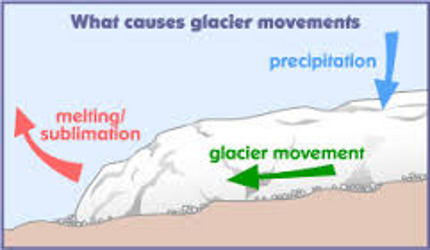
Two million years ago there was a major climatic change, snow and ice began accumulating in the northern part of Hudson Bay, Canada. The tremendous pressure of its weight caused the ice to flow, forming a massive continental ice sheet. During the Ice Age, ice sheets, one to two miles thick, extended from Canada south and covered almost all of New York State.
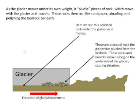
Geologists believe the glacier advanced a meter each day. When the leading edge of the glacier began to melt at a rate as fast as the ice was flowing, the forward movement of the leading edge stalled but the ice still continued flowing picking up anything in its path and transporting it towards the leading edge. The glacier, filled with mud, sand, gravel and boulders, had a rough underside that ground, polished and scoured the surfaces it contacted.
Glaciers take the easiest path - usually a path already cut by streams. Where glaciers flowed parallel to V-shaped river valleys, they gouged the valleys into troughs with U-shaped cross-sections. Glacial ice puts the most erosion on the lower portion of the valley sides, so it widens out the V shape into a U. Additionally, the slow flowing ice erodes the insides of meanders, straightening out once sinuous river channels, and creates a wider and straighter valley. Upon the retreat of the glacier, these valleys are often filled with sand and gravel deposits that had been transported by the glacier.
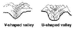
You are standing in a glaciated valley that extends from East Aurora to Holland. The topographic map shows the typical U-shape valley cross-section with a wide flat bottom. The glacier has left behind several lasting benefits. The valley provides an easy transportation route and the well-drained flat fertile land has agricultural benefits. The concentration of sand and gravel deposits to the South is a source of valuable construction materials. Additionally, the elevation of the valley sidewalls provides an ideal location for communication towers.
The listed coordinates provide an ideal location to view the valley cross-section. Route 16 has wide shoulders from which the required observations can be made. To claim credit for this EarthCache, please answer the following questions. Do not post your answers in the log. You do not need to wait for a confirmation of your answers before logging your visit.
1. Using relative terms, compare the width of the valley floor to the height of the sidewalls at this location.
2. On the Mohs Scale, ice has a hardness of 1.5 and the local bedrock in this area, shale, has a hardness of 3.0. In your own words, explain how glacial ice can abrade material that is much harder.
3. The railroad is located to the East. What factors led to choosing this route for the railroad?
4. (optional for extra credit) What do you think caused the climatic change that started the Ice Age?