Local geology:
The Chautauqua Hills represent a narrow region in southeast Kansas of sandstone capped ridges and rolling hills. The Pennsylvanian age sandstones were deposited in a large river valley. The sandstones are the Tonganoxie Sandstone Member of the Stranger Formation and Ireland Sandstone Member of the Lawrence Formation. The hills occur in the western portions of Montgomery, Wilson and Woodson counties and the eastern edges of Chautauqua, Elk and Greenwood counties. The sandstones continue into northern Oklahoma.

As you can see the area of focus is with Pennsylvanian age rocks, that is, 323.2 - 298.9 million years ago.
TOR:
A tor is a large, free-standing residual mass (rock outcrop) that rises abruptly from the surrounding smooth and gentle slopes of a rounded hill summit or ridge crest. (Elephant rocks in Missouri are a classic example of tors)
Tors may develop in a range of different rock types including granite, volcanic rocks metamorphic rocks or hard sedimentary rocks such as quartzite and sandstone. Tors are mostly less than 16 feet high. Formation processes and ages vary widely across different climates, elevations, and rock types
Erosion
Erosion is the process by which soil and rock are removed from the Earth's surface by natural processes such as wind or water flow, and then transported and deposited in other locations. In this particular area at GZ, Water has caused most of the Erosion here.
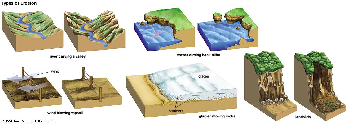
Types of Erosion:
Splash Erosion: Small soil particles are detached and sent airborne through the impact of raindrops on soil.
Sheet Erosion: Raindrops break apart the soil structure and it's moved down-slope by water that flows overland as a sheet rather than definitive channels. This occurs frequently during cloud bursts.
Rill Erosion: This process develops small, short-lived, concentrated flow paths. These paths create a sediment source and delivery system for hill-slope erosion. Areas where precipitation rates exceed soil infiltration rates are more prone to this type of erosion.
Gully Erosion: Water flows in narrow channels during or directly following heavy rains or melting snow. The gullies can erode to considerable depths.
Valley or Stream Erosion: Continual water flow alongside land (along a linear feature) creates this type of erosion. It extends downward, deepening a valley, and head-ward, extending the valley into the hillside. This occurs most frequently in times of flooding.
Bank Erosion: Over time, banks of rivers and streams are naturally worn down.
Freezing and thawing: Cold weather causes water trapped in tiny rock cracks to freeze and expand, breaking the rock into several pieces.
Wind erosion is a major geomorphological force, especially in arid and semi-arid regions. Wind erosion is of two primary varieties: deflation, where the wind picks up and carries away loose particles; and abrasion, where surfaces are worn down as they are struck by airborne particles carried by wind.
Mass movement is the downward and outward movement of rock and sediments on a sloped surface, mainly due to the force of gravity. Mass movement is an important part of the erosional process, and is often the first stage in the breakdown and transport of weathered materials in mountainous areas. It moves material from higher elevations to lower elevations where other eroding agents such as streams and glaciers can then pick up the material and move it to even lower elevations. Mass-movement processes are always occurring continuously on all slopes; some mass-movement processes act very slowly; others occur very suddenly, often with disastrous results.
Source: (water)
Sources
**Logging requirements**
DO NOT POST ANSWERS IN YOUR LOG.
Send the following answers to me via email.
- The text "GC5F6YW Point Rock" on the first line
- What are the width, height and depth (depth = thickness) of the biggest rock?
- Is there an angle that the biggest rock is pointing towards more than any other?
- Run your hand across the rock of the biggest rock what is its texture?
- Based on your observations, is this rock a tor? (Look at the ground to the west of the biggest rock)
- Looking at the other two waypoints, do these rocks match up in texture, and color with the biggest rock?
- What are the two major erosional forces that would be working away on these rocks?
| I have earned GSA's highest level: |
 |