[JP]
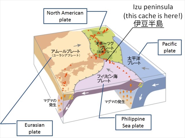
このEarthcacheが存在する伊豆半島は、本州の中で唯一フィリピン海プレートに乗っている非常にユニークな場所です(下図参照)。
[EN]
Izu peninsula where this Earthcache exists is a very unique place as it is the only place in Honsyu (the main island of Japan) which is on the Philippine Sea plate (see the figure below).
[JP]
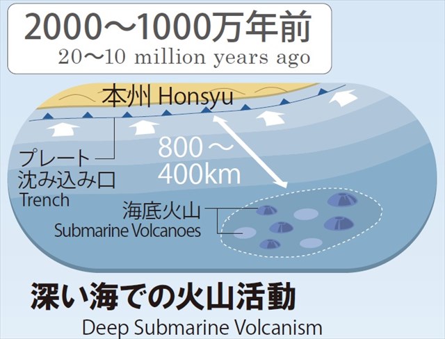
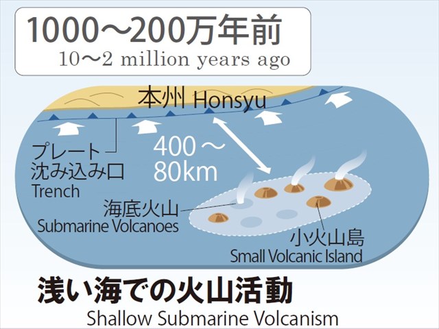
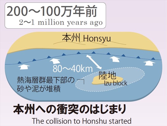
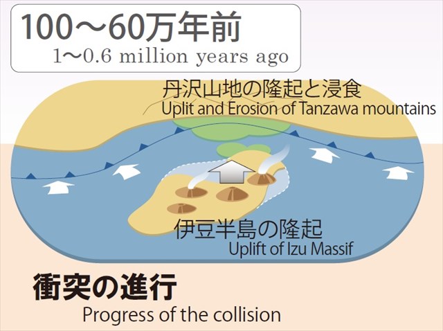
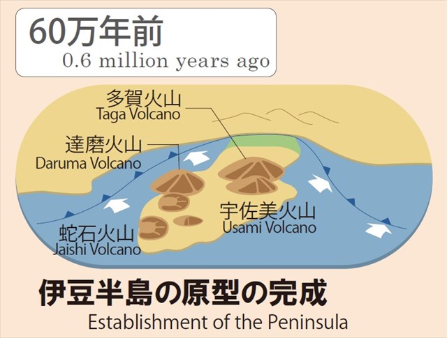
伊豆半島は、おおむね以下の図(伊豆半島ジオパークWebサイトより引用)に示すように形成されたと考えられています。
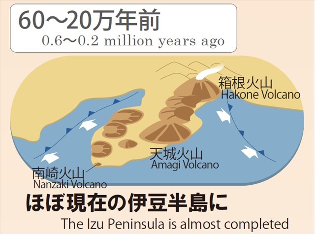
すなわち、大昔には本州から数百km離れた海中にあった海底火山が、フィリピン海プレートに乗って本州へと運ばれて来るにつれて隆起し、丹沢山地を隆起させながら日本に衝突しました。衝突後もなお北上を続け、60-20万年前の間の箱根火山や富士火山の形成や、20万年前以降の東伊豆単成火山群(単成火山:一度のみ噴火した火山)の形成などの火山活動を引き起こしています。
[EN]
It is thought that Izu peninsula has been formed as shown in the successive figures below cited from Izu peninsula Geopark website.
That is, the submarine volcanoes which used to be far from Honsyu by several hundreds kilometers were carried on the Philippine Sea plate to Honsyu and uplifted, and finally collided against Honsyu with uplifting Tanzawa mountains and forming Izu peninsula. Izu peninsula is still moving toward the north and causes volcanic activities, like formation of Hakone and Fuji volcanoes during 0.6-0.2 million years ago and formation of Higashi Izu monogenetic volcanoes (not shown but explained later in this listing with another figure. "monogenetic volcanoes" mean volcanes whiched erupt only once).
火山の根/Volcanic necks
[JP]
このように形成された伊豆半島には、海底火山の名残である「火山の根」が至る所に残されています。
[EN]
In Izu peninsula so formed, there remains "volcanic necks" (also called as "volcanic plug") left by submarine volcanoes here and there.
[JP]
火山の根は下図(伊豆半島ジオパークWebsiteから引用)のように形成されます。
[EN]
Volcanic necks are formed as shown in the figure below excerpted from the picture of the information board I took at one of the geosite of Izu peninsula geopark.

[JP]
下の写真(Wikipediaより引用)は、アメリカのワイオミング州にあるDevils Towerと呼ばれる火山の根です。表面には顕著な柱状節理が見られます。柱状節理はマグマが冷却されて固まる際に体積が収縮した結果生じる規則正しい割れ目(六角形が多い)です。割れ目の方向は、冷却方向と平行(冷却面に垂直)です。Devils Towerでは、割れ目が縦方向であることから、火口から下方向に冷却が進んだと考えられます。
[EN]
The picture below cited from Wikipedia shows one of volcanic necks, Devils Tower of Wyoming, USA. You can see that the volcanic neck has remarkable columnar joint. Columnar joint is regular fracture (often having a cross-section of hexagonal shape) caused by shrinking of volume when magma gets cooled. The direction of fractures is parallel to the direction of cooling (i.e. perpendicular to the cooling surface). In Devils Tower case, it is assumed that the cooling was downward from the volcanic vent opening, because the fractures run longitudinally.

[JP]
さて、公開座標付近の獅子浜でも石英安山岩からなる火山の根を観察することができます。下の写真はその一部ですが、Taskに関連して向きを変更してあります。
[EN]
Around the published coords, you can observe a volcanic neck of dacite. The pictures below show magnified parts of it. The orientations of the pictures are changed, i.e. oblique to the original orientation, with respect to Task.


Tasks for claiming your found log
[Task 1]
[JP]
公開座標を訪れて、上の写真の火山の根を実際に観察してみましょう。
*注:Additional Waypoint ”防潮扉_tide gate”にある扉が開いていれば、公開座標まで容易にアクセスすることができます。この扉が閉じている場合には、少し離れたAdditional Waypoint "堤防_dike"から、公開座標付近の火山の根を観察することができます。
[EN]
Visit the published coords, and observe the volcanic neck shown in the pictures above.
*Note: When the gate at Additional Waypoint "防潮扉_tide gate" is open, you can easily access to the published coords. When the gate is closed, you can also observe the volcanic neck from Additional Waypoint "堤防_dike", although it is a bit far.
[Task 2]
[JP]
以下のクイズの答えをCache ownerにメッセージしてください。
[EN]
Send your answers for the questions below to the cache owner.
Question 1
[JP]
座標地点で観察される火山の根の柱状節理の方向は(方角ではない)?上述のDevils Towerと比べてみましょう。
[EN]
What is the direction (not a bearing) of fractures of the columnar joint? Compare with that of Devils Tower.
Question 2
[JP]
Question 1の答えから、ここの火山の根を形成したマグマはどの方向に冷却されたと考えられますか?マグマは火道中の浅いところと深いところのどちらで冷却されたでしょうか?またその冷却源は?上の「火山の根のでき方」の図を見て考えてみましょう。
[EN]
According to the answer for Question 1, Into which direction was the magma which formed this volcanic neck cooled? In which of shallow or deep place in the vent was the magma cooled? What was the cooling source? Let's think by referring to the above figure "Formation of volcanic neck".