[JP]
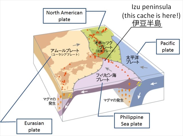
このEarthcacheが存在する伊豆半島は、本州の中で唯一フィリピン海プレートに乗っている非常にユニークな場所です(下図参照)。
[EN]
Izu peninsula where this Earthcache exists is a very unique place as it is the only place in Honsyu (the main island of Japan) which is on the Philippine Sea plate (see the figure below).
[JP]
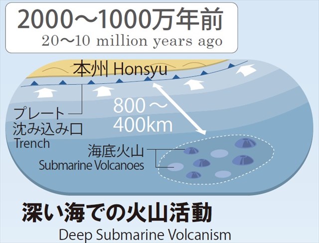
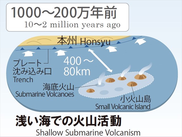
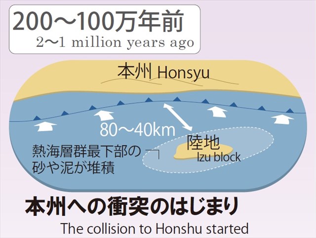
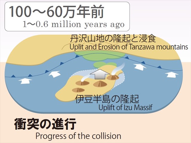
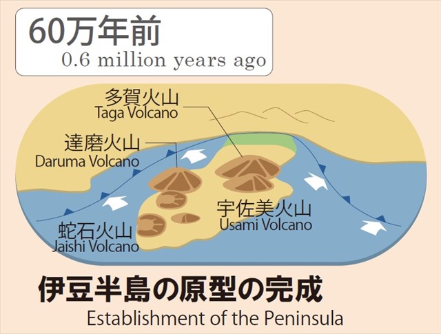
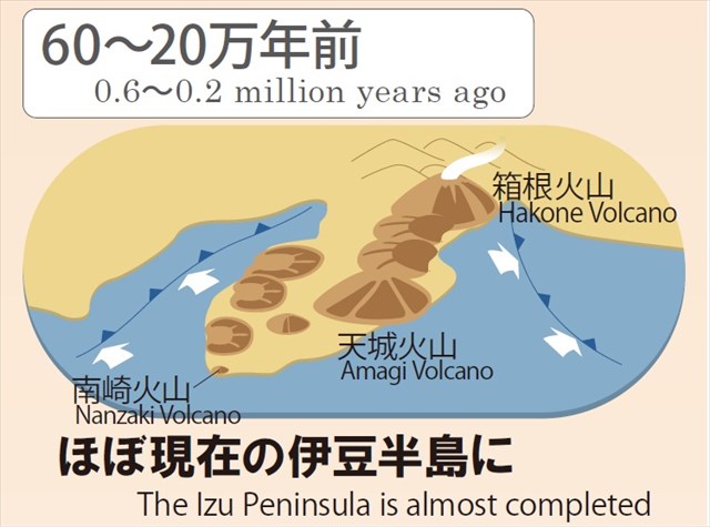
伊豆半島は、おおむね以下の図(伊豆半島ジオパークWebサイトより引用)に示すように形成されたと考えられています。
すなわち、大昔には本州から数百km離れた海中にあった海底火山が、フィリピン海プレートに乗って本州へと運ばれて来るにつれて隆起し、丹沢山地を隆起させながら日本に衝突しました。衝突後もなお北上を続け、60-20万年前の間の箱根火山や富士火山の形成や、20万年前以降の東伊豆単成火山群(単成火山:一度のみ噴火した火山)の形成などの火山活動を引き起こしています。
[EN]
It is thought that Izu peninsula has been formed as shown in the successive figures below cited from Izu peninsula Geopark website.
That is, the submarine volcanoes which used to be far from Honsyu by several hundreds kilometers were carried on the Philippine Sea plate to Honsyu and uplifted, and finally collided against Honsyu with uplifting Tanzawa mountains and forming Izu peninsula. Izu peninsula is still moving toward the north and causes volcanic activities, like formation of Hakone and Fuji volcanoes during 0.6-0.2 million years ago and formation of Higashi Izu monogenetic volcanoes (not shown but explained later in this listing with another figure. The word "monogenetic" means "formed from one source or by one process." So "monogenetic volcanoes" mean volcanoes which erupt only once).
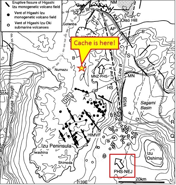
[JP]
下図(Journal of Geography, 104(1), 45-68, 1995より引用)において、伊豆半島が現在も本州へと押し込まれている方向が、矢印"PHS-NEJ"(下図右下の赤い四角で囲まれた矢印)で示されています。すなわち、伊豆半島には、概してこの矢印PHS-NEJ方向に圧縮力が作用していると考えられます。
[EN]
In the figure below (cited from Journal of Geography, 104(1), 45-68, 1995), the direction into which Izu peninsula is pushed against Honsyu even now is shown with the arrow "PHS-NEJ" framed in by the red rectangle on the bottom-right corner. That is, we can generally said that compressing force is applied to Izu peninsula in the direction of this arrow "PHS-NEJ".
[JP]
一方、この圧縮力と垂直な方向には岩盤に対する拘束力が弱く、地中から上昇するマグマの圧力などによって岩盤に割れ目が生じ、この割れ目にマグマが貫入して上昇し、地表に達して単成火山となります(モデル図を以下に示します)。上図において、これらの単成火山の火口分布が黒丸で示されています。上図中の太直線は、推定される地中の割れ目の位置を示しており、それぞれの太直線上の黒丸は同じ割れ目に貫入したマグマによって発生した火山の噴火口であるといえます。マグマの貫入により、岩盤は太直線に対して垂直方向に押し広げられています。
[EN]
On the other hand, in the direction perpendicular to this compressing force, restraint to the rock of the peninsula is weak, thus eruptive fissures were caused by, for example, pressure of magma ascending from the earth. Magma intruded into these fissures and reached to the earth's surface, and finally erupted as monogenetic volcanoes (a model of such a eruptive fissure and monogenetic volcano is shown in the figure below). In the figure above, the distribution of vents of these monogenetic volcanoes is shown with black dots. The thick lines in the figure show assumed eruptive fissures in the earth, the black dots on each thick line are vents of the volcanoes caused by the magma intruded in the same fissure representing with thick line. Due to the intrusions of magma, the rock is pushed out in the direction perpendicular to the thick lines.
[JP]
要約すると、伊豆半島には、北西-南東方向に圧縮力が作用し、北東-南西方向に引張力が作用していると考えられます。
[EN]
In summary, it can be generally supposed that, in Izu peninsula, compressing force acts in the NW-SE and pulling force acts in NE-SW.
[JP]
伊豆半島に作用するこれらの力によって、この地域では多くの断層が活動し、何度も大地震が発生しています。
[EN]
Due to these forces acting in Izu peninsula, many faults have been activated, and many major earthquakes have been happened ever in Izu area.
[JP]
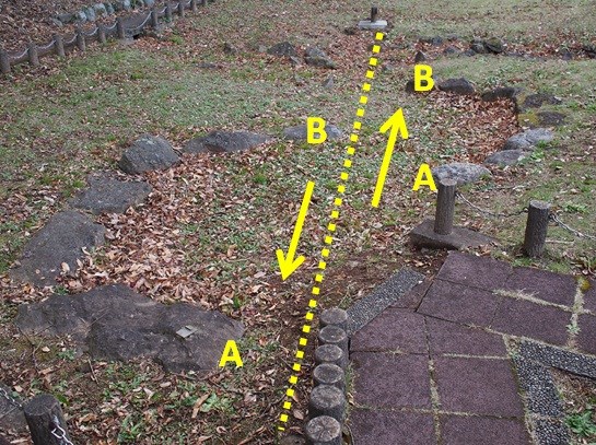
そのような断層の1つである丹那断層が、公開座標のところに保存されています(下の写真参照:破線が断層を示しています)。この断層は、1930年11月26日に発生した北伊豆地震の際に発生した断層です。発掘調査の結果、丹那断層は約1000年の間隔で比較的規則的に活動してきたことが分かっており、過去8000年間に9回の地震を引き起こしています。
[EN]
At the published coords, one of such faults, Tanna fault, is preserved(see the picture below. The dotted line represents the fault). This fault is a fault caused when North Izu earthquake happened in November 26, 1930. According to the excavation investigation, it has been found that Tanna fault moves relatively regularly at intervals of about 1000 years, and has caused earthquakes nine times during the last 8000 years.
[JP]
地震前は円形に組まれていた石組みが、断層の運動により、水平方向にずれたことが分かります(写真中の矢印とA, B参照)。そして断層を挟んで反対側の地層が左方向にずれていることから、この断層は「左横ずれ断層」と呼ばれます。
[EN]
You can see that stones arranged in circle before the earthquake were sifted horizontally with the fault movement as shown with the arrows and letters 'A' and 'B' in the picture above. This type of fault is called as a "left-lateral" fault, because the counterpart across the fault is sifted leftward.
[JP]
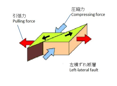
左横ずれ断層は下図に示すような方向に作用する力によって生じます。
[EN]
Left-lateral faults are caused with forces in the directions shown in the figure below.
Tasks for logging
Task 1
[JP]
公開座標を訪れて、保存されている丹那断層を観察してください。
[EN]
Visit the published coords, and observe the Tanna fault preserved there.
Task 2
[JP]
以下の2つの質問に対する答えをcache ownerにメッセージしてください。
[EN]
Send your answers for the two questions below to the cache owner.
Q1
[JP]
丹那断層の方位(上の写真の破線の方位)は?
[EN]
What is the azimuth orientation of Tanna fault (the orientation of the dotted line in the picture above)?
Q2
[JP]
Q1に対する答えから考えて、どのような力が丹那断層を引き起こしたと考えられますか?
[EN]
Considering from your answer for Q1, what forces caused Tanna fault?