Welcome to the cave known to the Missouri Department of Conservation as “Watkins cave”, however there have been many names associated with this cave. Caves are unique in that no two are alike because erosion and rock harness play a different factor in each situation. While you will not be allowed to enter the cave, unless you apply for a permit, you will still be able to see the layout and some unique features of this cave system.
Even though you are not going to be able to enter this cave
the park ranger superintendent wants to make sure everyone stays safe.
- Make sure you wear hunter orange during the hunting seasons CLICK HERE
- Do be careful around the sinkholes and don’t enter them.
- The park is only open from sunrise to sunset
- Do not walk on the often very slick steel grates that cover the cave
This unique area
While walking up to the cave you will cross the primary first fence and immediately notice the sinkhole off the left as you walk up to the cave’s first entrance. This tells us that the cave goes both to the east AND to the west. Eventually this sinkhole will open up to show another entrance to this cave. This sinkhole looks to be about 4-5 foot deep and has about 20 foot diameter.
Once you reach the cave’s main triangle box entrance you will notice that the 6 foot high triangle box is also attached to an area of flat laying steel grate to the east. Under this flat laying part you will notice a “punchbowl seat” erosion feature which is along the north wall of the cave. This is caused by “slash” erosion and shows how powerful this type of erosion can be.
A little further to the East there is another section of flat laying steel grate covering the entrance area that was created when the caves roof collapsed. You can see the rocks laying on the cave floor.
Erosion
Erosion is the process by which soil and rock are removed from the Earth's surface by natural processes such as wind or water flow, and then transported and deposited in other locations.
Types of Erosion:
Splash Erosion: Small soil particles are detached and sent airborne through the impact of raindrops on soil.
Sheet Erosion: Raindrops break apart the soil structure and it's moved down-slope by water that flows overland as a sheet rather than definitive channels. This occurs frequently during cloud bursts.
Rill Erosion: This process develops small, short-lived, concentrated flow paths. These paths create a sediment source and delivery system for hill-slope erosion. Areas where precipitation rates exceed soil infiltration rates are more prone to this type of erosion.
Gully Erosion: Water flows in narrow channels during or directly following heavy rains or melting snow. The gullies can erode to considerable depths.
Valley or Stream Erosion: Continual water flow alongside land (along a linear feature) creates this type of erosion. It extends downward, deepening a valley, and head-ward, extending the valley into the hillside. This occurs most frequently in times of flooding.
Bank Erosion: Over time, banks of rivers and streams are naturally worn down.
Freezing and thawing: Cold weather causes water trapped in tiny rock cracks to freeze and expand, breaking the rock into several pieces.
Wind erosion is a major geomorphological force, especially in arid and semi-arid regions. Wind erosion is of two primary varieties: deflation, where the wind picks up and carries away loose particles; and abrasion, where surfaces are worn down as they are struck by airborne particles carried by wind.
Mass movement is the downward and outward movement of rock and sediments on a sloped surface, mainly due to the force of gravity. Mass movement is an important part of the erosional process, and is often the first stage in the breakdown and transport of weathered materials in mountainous areas. It moves material from higher elevations to lower elevations where other eroding agents such as streams and glaciers can then pick up the material and move it to even lower elevations. Mass-movement processes are always occurring continuously on all slopes; some mass-movement processes act very slowly; others occur very suddenly, often with disastrous results.
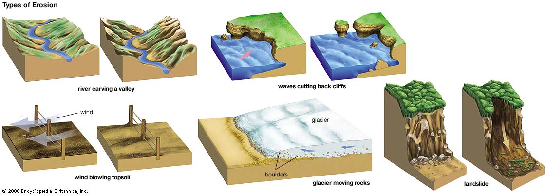
Source: (water)
Karst topography
Karst topography is a geological formation shaped by the dissolution of a layer or layers of soluble bedrock usually carbonate rock such as limestone or dolomite. Subterranean drainage may limit surface water with few to no rivers or lakes. Many karst regions display distinctive surface features, with sinkholes being the most common. However, distinctive karst surface features may be completely absent where the soluble rock is mantled, such as by glacial debris or confined by one or more superimposed non-soluble rock strata. Some karst regions include thousands of caves, although evidence of caves large enough for human exploration is not a required characteristic of karst.
Types and formation
A cave or cavern is a hollow place in the ground, especially natural underground space large enough for a human to enter. Caves form naturally by the weathering of rock and often extend deep underground.
solution caves
Solutional caves are the most frequently occurring caves and such caves form in rock that is soluble, such as limestone, but can also form in other rocks, including chalk, dolomite, marble, salt, and gypsum. Rock is dissolved by natural acid in groundwater that seeps through bedding-planes, faults, joints and so on. Over geological epochs cracks expand to become caves and cave systems.
primary caves
Caves formed at the same time as the surrounding rock are called primary caves.
Lava tubes are formed through volcanic activity and are the most common primary caves. As lava flows downhill, its surface cools and solidifies. Hot liquid lava continues to flow under that crust, and if most of it flows out, a hollow tube remains. Examples of such caves can be found in the Canary Islands, Jeju-do, the basaltic plains of Eastern Idaho and other places. Kazumura Cave near Hilo, Hawaii is a remarkably long and deep lava tube; it is 65.6 km long (40.8 mi).
How caves form
Cave formation begins when rainwater absorbs carbon dioxide as it falls through the atmosphere. Rain water must have carbon dioxide to become acidic. It must be acidic to chemically react to the limestone bedrock. Rainwater is absorbed by the soil into the ground.
As rainwater comes through the soil it absorbs more carbon dioxide that is being produced by plants that are dead. This changes the ground water to a weaker form of carbonic acid (H2O + CO2 = H2CO3). As it travels down through the ground it comes to solid rock. When the rock is limestone or dolomite caves can form.
The water reacts chemically with limestone and slowly a larger and larger space will form. This happens because the rocks are made of calcium carbonate (CaCO3). This is what you call chemical erosion.
As the space becomes larger and larger the water can flow through. As it flows it erodes. Physical erosion washes away rock and sand. This is what makes a cave larger and forms an underground stream. Finally over hundreds of thousands of years or even millions of years the cave is formed.

**Logging requirements**
DO NOT POST ANSWERS IN YOUR LOG.
Send the following answers to me via email.
- The text "GC5HXQ1 Watkins Cave" on the first line
- Inside the triangle box look at the Caves South side wall, is it natural or have humans rebuilt the walls because of erosion?
- What are the dimensions of this main entrance?
- Just to the east of the triangle box is another steel grate that is laying flat on the ground, describe this entrance.
- At waypoint “sign” finish the sentence “This cave is __________”
| I have earned GSA's highest level: |
   |