Getting there:
Black Point is approximately 2.5 hours from Augusta. Access is strictly by 4WD trek along a coastal track. Be sure to reduce your tyre pressure to 10psi as you begin driving on sand. Black Point Road is closed in winter but access may be possible via Wapet Track - at your own risk.
You can make a free day trip of it or camp although camping fees do apply. There are 20 camp sites at Humpback Hollow and 10 at Seal Cove with pit toilets, shaded peppermint trees and fire places. Untreated water is available but must be boiled before consumption.
Once parked you can reach the black basalt columns by a pleasant 1.5km stroll along the beachfront. The ocean is often pounding hard against the basalt. You may find it easier to visit during a quiet low tide to get close enough to hear their distinctive organ-like music as the waves and wind echo through the gaps in the basalt columns.
The Columns:
Defining the coastline are thin strips of white sand that characterise many of Western Australia’s beaches. These are broken up by rocky coastal cliffs that king waves routinely smash against. A section of these cliffs on the northern side of D’Entrecasteaux is impressive due to its puzzling symmetry. Black Point is named after these black volcanic basalt rock columns that are among the region's most spectacular attractions.
There are not that many places in the world where you can see these stunning rock formations. This is one of six sites that exist in the whole of Australia.

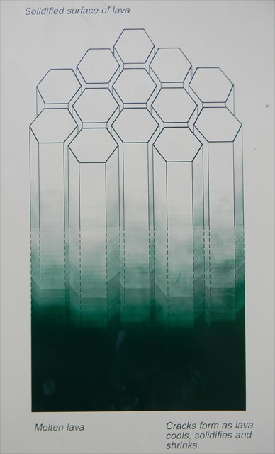
Basalt is one of the most common rock types in the world. This massive outcrop of black basalt was formed from an extensive volcanic lava flow originating from the Darling Fault around 135 million years ago. The basaltic lava erupted in large volume creating a deep pool which filled the Perth Basin. It then flowed from the Darling Scarp to the Southern Ocean where it slowly cooled and eventually fractured, similar to the development of mud cracks.
During the cooling of a thick lava flow, contractional joints or fractures form. If a flow cools relatively rapidly, significant contraction forces build up. While a flow can shrink in the vertical dimension without fracturing, it can't easily accommodate shrinking in the horizontal direction unless cracks form. The extensive fracture network that develops results in the formation of columns.
Large masses must cool slowly to form a polygonal joint pattern. When the contractional forces are distributed equally in each direction the columns are likely to take hexagonal shapes. The topology of the lateral shapes of these 'Stepping Stones' columns can broadly be classed as a random cellular network. These structures are predominantly hexagonal in cross-section but polygons with three to twelve or more sides can be observed.
Column Formation:
The size of the columns depends loosely on the rate of cooling. Very rapid cooling may result in very small columns (<1cm diameter) while slow cooling is more likely to produce large columns. These 'Stepping Stones' are now slowly being eroded away by the Southern Ocean.

Remember to take only photos and leave no trace of your visit. We hope you enjoy your visit to this fascinating area of Western Australia's southwest.
In order to get your smiley you may log this Earthcache straight away but then please email your answers to the questions to the CO. We will contact you ONLY if your answers need extra work. Logs with no answers sent will be deleted. Please do not post your answers in your log.
Q1. Are the columns at GZ loosely-packed or closely-packed?
Q2. Are they perpendicular or horizontal to the beach surface?
Q3. Do you think these columns were formed by fast cooling or slow cooling lava? Explain why.
Q4. Why are the columns on the island at WP1 significantly smaller in cross-section than those at GZ?
Q5. What evidence is there that erosion is taking its toll on the columns?