The Silvermine Nature Reserve, located in the Central Section of the Table Mountain National Park (TMNP) covers the undulating, rocky terrain from Kalk Bay all the way to Constantiaberg, with rock formations and sandstone cave systems, and, through which meanders the Silvermine River, considered one of only three pristine rivers in the South-Western Cape - flowing from Source to Sea - the topic of this EarthCache.

Silvermine gets its name from attempts, albeit unsuccessful, to mine silver at the then called "Zilwermijn" in these mountains as long ago as 1680, during the Dutch settlement at the Cape
Ruins of the mine shaft are still there, but neither visible nor accessible to the public.
It was significant, however, that the rocks immediately above these mine shafts contained a number of narrow bands of manganese ore, prevalent in various areas of the Cape Peninsula. These were black in colour, as is silver oxide, in places shiny as a result of geological process.
To quote Professor John S Compton : "One cannot help but wonder whether the mine was not in fact a fraudulent one, as has always been supposed, but that the early miners genuinely believed that they had found bands of silver-bearing ore".
Before proceeding onto the main topic, the river, lets briefly discuss these mineral ores to perhaps understand the early miners apparent misconception :
Minerals
Manganese - Mn
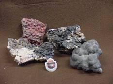
- gray-white brittle metallic element occurring in several allotropic forms, found worldwide, especially in Pyrolusite MnO2, but also Braunite, Silomelane and to a lesser extent, Rhodochrosite, together with nodules on the ocean floor.
Silver - Ag

- one of the famous precious metals, most of which is extracted from silver ores, while considerable amounts are also mined from native silver.
- a heavy metallic element with a brilliant white lustre, the chemical symbol derived from its Latin name, argentum, meaning "white and shiny", an apt description.
Geo Scientific studies indicate that the Cape Peninsula, of which TMNP forms a large part, was once divided by a large geological fault, what is today the Fish Hoek / Noordhoek valley, the so-called "Gap".
Refer EarthCache GC55K3R7 "Sea Passage . . . once upon a time !"
During the Ice Age, waters in this fault receded and, over the eons, were replaced by shifting sand dunes blown in from the shallow sea floor by onshore wave action and s-easterly winds.
Beach sands with shell fragments and estuarine muds were deposited and later overlain by calcrete-cemented dune sands as the sea retreated.
Plants introduced in modern times to stabilise the dunes became invasive and stifled indigenous flora. Efforts are on-going to clear that alien vegetation, though some fear this may cause the dunes to shift once more. Now largely buried under the homes and gardens of the Valley's growing population, the residual dunes remain a distinctive feature of the landscape around the Skildersgat (a.k.a. Peers) Ridge which straddles the valley floor as shown in the picture below.


With this as background, lets get started on the main topic, the Silvermine River :
Flow Path
The main river & several tributaries, from Source to Sea, can be traced in blue below.

Source
- The river has its main source on the Steenberg Plateau at an altitude of 640 m ;
- Secondary, seasonal sources are at several seeps, some above the reservoir in the Nature Reserve, others on the backs of the Constantiaberg and Kalk Bay Mountains.

(a seep is a moist or wet place where groundwater reaches the earth's surface from an underground aquifer as part of the limnology-geomorphology system).
Midway
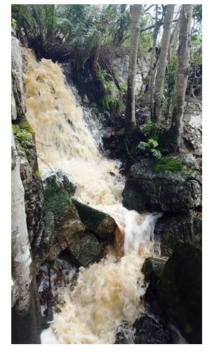
- From the Mountains the tea-/cola-coloured river flows in a s-w direction across the Steenberg Plateau, part of the "1 000 Foot Surface" formed during a period of faulting / upliftment ± 30 mya ;
- From the Plateau it then cuts southwards through a fairly deeply incised valley with waterfalls ;
- Whilst flowing strongly during the winter rainy season, the volume decreases considerably in summer to merely a trickle in some places ;
- Once it reaches the coastal plain (formed by the Fish Hoek - Noordhoek Gap) which is cut along a line of faulting separating the north and south Peninsula, it flows in a s-e direction along the base of the mountains towards the wetlands and the sea ;
- Having flowed a distance of some 12.3 km ;

Sea
- The river flows through the nearby wetlands into the sea at the estuary on the northern, Clovelly portion of Fish Hoek beach, where, from time to time in summer, insufficient volume inhibits it from actually reaching the sea ;
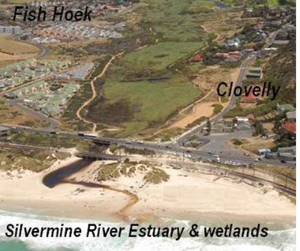
Housing encroachment on the Silvermine flood plain led to landscaping at the river estuary to control the flood-waters which included the planting of indigenous fynbos and the construction of gabion pools (wire mesh baskets compactly filled with rocks, wired together for erosion control structures).
In 1969 there was a plan to build a bridge and by-pass road, and the plan included partial canalising of the river. Concern at increasing development and the proposed canalisation led to the formation of the Silvermine River Society in 1985, which group actively removed and controlled alien vegetation along the banks of the river. Some two years later, it produced an excellent document, eventually accepted by the authorities, motivating how the river, rather than being canalised, could be preserved by formatting a flood control measure and maintaining a wetland aspect to the area.
Geology
This essential part of GeoScience plays a significant role in any EarthCache, so let's reflect on formations within the Silvermine area !
The dominant Table Mountain Group "TMG", which rests unconformally on the Cape Granite base, includes quartzitic sandstone, tillite and sandy sediments :
The Schematic below (not to scale) shows a geological west-east cross section through the Cape Peninsula, based on a section through the Back Table just south of Table Mountain. The basement layer consists in the main of Cape Granite (orange) with the Table Mountain Sandstone (blue) forming the steep escarpments that surround the 5 km-wide central plateau. It includes the upper layer, the Pakhuis Diamicite or "Tillite", (only a trace at the highest point), the Peninsula Formation (part of the blue) in the middle and lowermost, the Graafwater Formation (pink) which rests on the significant Cape Granite base.
It would seem pertinent to examine these in somewhat more detail . . .
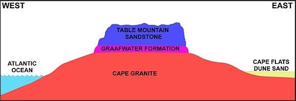
- Pakhuis Formation (atop) : During the laying down of the underlying Peninsula sediments, the western portion of the region was covered for a brief period by glaciers. The Diamictite sediments which were laid down then are known as "Tillite" which is composed of finely ground mud, containing a jumble of faceted pebbles. Only a small patch of this remains on the top of Table Mountain at Maclear's Beacon, the highest point ;
- Peninsula Formation (middle) : These rocks, previously referred to as Table Mountain Sandstone, consist of thickly layered quartzitic sandstone, a non-foliated metamorphic rock which was originally pure quartz sandstone, is usually white-gray in colour, though also occurring in shades of pink / red due to varying amounts of iron oxide. These sandstones are very hard and erosion resistant, forming the bulk of mountains and steep cliffs amongst which the upper portion of Table Mountain ;
- Graafwater Formation (below) : Initial sediments into the shallow Agulhas Sea of pre-historic times were alternating layers of maroon coloured mudstones and buff sandstones, each mostly between 10-30 cm thick. These mudstones commonly display ripple marks from the ebb and flow of ancient tidal currents, as well as polygonal sand-filled mud cracks that indicate occasional exposure to desiccation. This layer reaches a thickness of 60-70 m in the area.
Soils
Combinations, as in sand-clay ; sand-clay-loam ; loam-sand ; clay-loam ; sand-loam.
The river estuary is perceived to have "weird and wobbly" quicksand properties, relating to an event of old whereby a rider was reported to have lost his horse whilst traversing that portion of the beach. A possible explanation is that the seepage from the lagoon on the back-shore causes an internal upliftment of the sand deposits below the lagoon, resulting in unstable patches which would give in under load.
The bottom sediments of False Bay are more varied. On the western side there is a general tendency towards fine to medium quartzitic sand and coarser calcareous material, mostly mollusc shell fragments, with patches of "maerl" of branching coraline algae fragments.
Maerl should not be confused with the geological deposit "marl", rock containing clay and calcium carbonate.
Vegetation
- Fynbos grows on sandstone, sand, granite ;
- Strandveld grows on dunes ;
Catchment Area
- Extent 471 sq. km
- Mean Annual Precipitation 711 mm
- Mean Annual Evaporation 1 400 mm
- Mean Annual Runoff 73 mill. cub. m
Well, by now you will have reached or revisited the End Point to view the Estuary into which the Silvermine River flows, onto the beach, out to sea , so . . . whenever you're ready :

Questions
- Where is the main source of the river and at what elevation ?
- What type of water exudes from the secondary sources and how did it get there ?
- Adjacent to GZ an interesting metallic structure - describe and what do you think it's use ?
- At Estuary, before returning over the railway line, record last word on the sign ?
- The Table Mountain Group consists of three Formations. From the graphic, name the middle (blue) layer and what is it now known as ?
- Comment on the state of the river flow at the time of your visit ?
- Whilst no longer a Groundspeak specific requirement, photo of yourself(s) with GPS at either of the two co-ords would be of value in recording the current condition of river and / or estuary.
No spoiler photos of any signage please !
References
- www.za.govview.info/Silvermine_river
- www.csir.co.za/rhp/state_of_rivers
- www.wikipedia
- www.mtroutes.co.za
- Estuaries of the Cape
- Cape Town Mapping Project
Acknowledgements
Mossop, Leighan Senior Section Ranger, TMNP
Oelofse, Gregg Environmental Resource Mgmt, City of Cape Town
Information and Site Approval
Notes
GZ is situated in the Silvermine Nature Reserve, in vicinity of the reservoir ;
Entry requires a Wild Card or Green Card (SA Residents only) or Day Fee ;
You may wish to seek other nearby Caches in the reserve during your visit ;
Best route to Estuary is via Ou Kaapse Weg - Noordhoek - Fish Hoek ;

