An Overview of the rock that makes the Lizard
The Lizard has a complex but fascinating geology, one that is hugely different from the rest of Cornwall, and even much of the England. Although the Lizard already boasts a number of earthcaches dealing with specific coastal features, there wasn’t one that looks at the underlying rock that makes up this peninsula and so this earthcache attempts to give you a flavour of what makes this place so special.
The Lizard is geologically different from the rest of Cornwall because it is an ophiolite complex. To put it simply, a section of oceanic crust was thrust over continental crust after a collision between two continents, overlying metamorphosed mostly sedimentary rocks, originally slates, sandstones and volcanics, now changed into mica-schists and quartzite. These original rocks, known as the Old Lizard Head Series, are rarely exposed, one of the only places where they can be clearly seen being at Lizard Point. There are a large number of different rock types across the Lizard as the diagram shows below. This earthcache doesn't look to investigate all of them, but the diagram helps you to understand how much is going on geologically on the Lizard Peninsula.

Some further geological background for the Lizard
Let’s get slightly technical for a couple of paragraphs, more intended for those people who have a basic geological background. You will often see visiting groups of university students on the beaches of Lizard investigating the relations between the serpentinised mantle peridodites and the overlying crustal gabbros. There are two types of peridodites, and these are represented by a heavily oliated orthopyroxene(enstatite)-rich serpentinite and less foliated, less orthopyroxene rich serpentinite which is typified by the presence of amphibole (tremolite). That’s all very technical, but the boundary between these two types of serpentinite can be studied at Kynance Cove, and geologically this represents the boundary between shallow mantle peridotites from which material has been extracted by melting and deeper peridotite from which no material has been removed.
Between Coverack and Kennack Sands there is a marked narrow promontory known as Carrick Luz. This is the remains of a great fissure in the serpentine that acted as the feeder for the overlying gabbro. In a few places, such as around The Manacles, Leggan Cove and the West of England Quarry at Porthoustock, instead of gabbro we can see dolerite and basalt dyke swarms that poured lava up through the gabbro onto the ancient sea floor. The actual lavas have since been removed by erosion or metamorphosed almost out of recognition.
There is a huge time gap of 350 million years between the great events that emplaced the rocks of the Lizard on Cornwall, and today. It is becoming clear that many of the faults that control the development of the current shape of the coast and the location of the inland valleys, had formed in the first 75 million years after the Lizard was thrust up. It is within these and associated cracks that you find spectacular minerals, very different in nature from those associated with the granites, which are known as zeolites. Particularly fine collections can be seen in the Helston Folk Museum and the Rashleigh Gallery at The Royal Cornwall Museum in Truro.
Simple Stuff: The rocks here at Lizard Point

Lizard Serpentine
The most extensive rock type on the Lizard is the serpentine which, spanning 20 square miles, is the largest outcrop of such rock in mainland Britain. It is found nowhere else in England. This serpentine was originally deeply buried material from the Earth's mantle such as peridotite. This contains large amounts of minerals like olivine and pyroxene, which have been altered to create the rock serpeninite – a rare example of metamorphism resulting from a decrease, rather than an increase in temperature and pressure. This rock, so named because it resembles snake skin, is banded and streaked with veins, and polishes to a very attractive red, green and black rock. When Queen Victoria and Prince Albert visited the area in 1846, they were so struck by serpentine's unusual characteristics, that their ensuing royal patronage spawned an industry of architectural and decorative stone working which became extremely popular for ornaments in Victorian times and is still quarried in small quantities for tourist souvenirs. You might not spot much of it here at Lizard Point (see top diagram for the main areas it is located).

Man of War Gneiss
The two rocks you will definitely find at the most Southerly Point, here at Lizard Point, are some of the oldest known rocks in the whole of Cornwall. These rocks, the Man of War Gneiss (above) and the Old Lizard Head mica schists (below), are over 500 million years old. The gneiss, with its corrugated texture, can be seen only as boulders on the beaches around the Most Southerly Point. They have been brought in by the waves from the offshore reefs, such as Shag and Labham Rocks. The Old Lizard Head mica-schists should be in ample supply around the cove.

Old Lizard Mica-schist
It is probable that much of Cornwall and the Lizard was covered by the high sea levels that deposited the chalk elsewhere in Britain 65 million years ago. Inland the evidence has been eroded away but flint (weathered out of chalk) is regularly washed up along the south coast, perhaps from the still existing bed of Cretaceous rocks under the sea off Black Head and The Lizard Point. Nearby Loe Bar (SW 643243) is composed of 86% flint.
Background to the Questions
This is a simple two stage earthcache that involves you having a look at the rocks whilst walking between two points so please note the presence of the second stage (which is down on the beach beyond the old lifeboat station). Please don't be put off by the questions, they only ask you to do a bit of field research and exploring for yourself - you have the opportunity at Lizard Point to view some very rare rock types and the only way to identify them for yourself is to explore! Please don't base your answers on what other people have written. It doesn't matter if you don't get it quite right, everyone has different geological abilities.
Please note - this is an area of Special Scientific Interest (SSSI) and Natural England have given their consent for this earthcache to be published. You can touch the rocks but please only gently, please do not remove anything from the site or interfere with the flora or fauna. Specifically, visitors have been asked to avoid any areas where you may disturb nesting birds.

The above diagram shows the rough layout of the rock at the Lizard. You will find boulders of the Gneiss that have been washed onto the beaches.
Part 1 – Record this answer in your log
Please begin at the given co-ordinates and make your way to stage two, looking at the rocks you pass along the route. From stage 1 you can look out over the most southerly part of the Lizard, rocks that are now cut off from the mainland and are slowly being affected by the sea. As you walk down onto the beach you will have the opportunity to see some of the rocks close up.
- Can you see any Man of War Gneiss? This would be in the form of boulders on and around the beaches? If the tide is in they may only be visible through the clear water. You will also be able to view the Gneiss out at sea in the distance (see above diagram/photo). Photos of the Man of War Gneiss would be appreciated, but are not mandatory, Please also describe what you see. Textures, colours and anything that makes this rock different to the others nearby.
- Can you see any Lizard mica-schist? (see above above diagram/photo). There should be plenty about. Photos of the Old Lizard Mica-schist would be appreciated, but are not mandatory. Please describe what you see. Textures, colours and anything that makes this rock different to the others nearby.
- Can you see any serpentine? (see photo). Photos of the Lizard Serpentine would be appreciated, but are not mandatory. Please describe what you see. Textures, colours and anything that makes this rock different to the others nearby. Serpentine is prominent across most of the Lizard Peninsula but less likely to be spotted here so don't worry if you don't find any, but do check the pebbles as well.
- Can you see anything else? Is there any gabbro (the common rock in mainland Cornwall)? Can you spot any washed up flint on the beach, or anything else that doesn’t fit into the three rock types above? Examine the pebbles, you may be surprised what you can find. What do you think you have found? Feel free to include a photos and descriptions if you wish.
You are more than welcome to include photographs and descriptions from elsewhere on the Lizard for this question in addition to what you see here. Please note where you saw the features. Kyzance Cove for example has superb examples of the two types of serpentine that are very accessible, and you will find Serpentine across the Lizard Peninsula (see the top diagram for locations). Another rock unique to the Lizard is the Kennack Gneiss, found at Kennack. Just before the turn off for Coverack on the main Helston to St Keverne road there is a small exposure of quartz-rich pebbles and cobbles of Tertiary age, probably deposited 25 or more million years ago and derived from the killas and granites north of the peninsula. There is small picnic area here which should be treated with respect for this really is ancient ground. You can see the quartz Crousa Gravels on the banks of the little pool, known as Dolly's Pool, here. If you go in a church, you will find the Lizard characteristically have beautifully shaped and polished serpentine fonts, lecterns and bible stands. There are many other places as well, due to the area offering such diverse geology.
Part 2 – To be sent to be via my profile
- Please take an elevation reading at stage 1 from your GPS device and a second elevation reading on the beach at/near stage 2. Send me those two figures. Also, calculate what is the height difference between these two levels? If the tide prevents you getting right to stage 2 make your measurement as near as you can safely go and also estimate how much further it might be.
- We have already mentioned how the rock you see here is from very deep down in the mantle of the Earth, and you have now studied the rock yourself. Would you describe the rock as hard or soft, and how quickly would you expect it to erode. Make comparisons again more common rocks found elsewhere in the country such as granite, gritstone, limestone and sandstone etc when making you answer, and therefore would you expect the Lizard to erode away quickly or not?
A photo of yourself or GPSr at Lizard Point would add additional proof that you have visited the most southerly earthcache in the country, it would be a nice souvenir for yourself and additionally I would appreciate it. It is not mandatory.
Please message me the answers to part 2 before you log your find. No logs will be deleted without prior warning as I would like to encourage people to attempt earthcaches and appreciate the time you put into them. However, if you do not respond to the warning your log may be deleted. Many thanks for visiting this earthcache, please enjoy your visit.
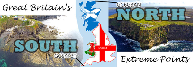
Great Britain's Extreme Points Badge
There is now a profile badge available if you have successfully logged both this earthcache and the sister earthcache at Dunnet Head.
Copy and paste the below code into your profile if you wish to display the badge.
<a href="http://coord.info/GC5KK3T"><img src="https://s3.amazonaws.com/gs-geo-images/8c08a40e-dd6c-446f-bf3d-4bd9bd532364.jpg" /></a>
Please enjoy your visit to Lizard Point.