Kirstenbosch National Botanical Garden
lies in the heart of the Cape Floristic Region, declared a UNESCO World Heritage Site in 2004 and one of the seven "Magnicent Botanical Gardens of the World" - the topic of this EarthCache.


The entire Estate comprises 528 hectares, the Garden itself constitutes 32 hectares.
A Brief History
Centuries old trees at the Garden bear witness to the history of the land over the past 350 years, but Stone Age hand axes found in the vicinity indicate that people had been living here in prehistoric times.
The Dutch East India Company established a half-way house at the Cape in 1652 for ships en route to, and from the Spice Islands of the East, with Jan van Riebeeck as the first Governor.
The forests on the slopes were used for timber by the DEIC (VOC) from 1657 and belonged to the Company until the first British Occupation of the Cape in 1795. Already in 1659, van Riebeeck had planted some 10 000 grapevines on the eastern slopes of Table Mountain, including the area where Kirstenbosch is now situated. Many fruit trees, other trees such as oaks, chestnuts, grey poplars and even wheat lands were planted on the property too.
By this time, contact had been made with the original inhabitants of the Cape, the Khoikhoi (a.k.a. Khoisan, but no longer as "Hottentots" - a disrespectful name now). These native pastoral people of south-western Africa had grazed their livestock in this general area for a long time and were full of praise for the land, so the Dutch nostalgically called nearby mountains to the east, Hottentots-Holland after them.


Extensive area in yellow is where the Khoikhoi / KhoiSan are known to have roamed.
The relationship was. however, less than amicable. In an attempt to keep them out of the settler areas, van Riebeeck had a lengthy, semi-circular hedge of almond trees, prolific in the area, planted as a barrier, alienating the Khoikhoi further by denying them grazing for their livestock and even permission to harvest some of the almonds which had been an integral part of their diet for years.
In the 1700's the land was managed by J.F. Kirsten on behalf of the VOC and it is thought that his surname is the origin of the Kirstenbosch name.
After the second British Occupation ended in 1806, the land was bought jointly by the Colonial Secretary and his Deputy. Subsequently, privately owned from 1811, farmed from 1823 until 1895 when it was puchased by Cecil John Rhodes with the intent of protecting the easten slopes of Table Mountain from urban development.
As busy as he was, Rhodes sadly allowed the land to become neglected and the homestead was left vacant , soon falling into ruin. On his death in 1902, the land was bequeathed to the Government and the Forestry Department planted the estate with pines and eucalyptus.
In May 1913 the Government of the day set aside Kirstenbosch Estate, being 32 hectare in extent, for the establishment of a National Botanical Garden, The Board of Trustees first met in June 1913 and appointed Prof. Harold Pearson, Head of Botany at the South African College, as Honorary Director and Jimmy Mathews as Curator. On 01 July 1913, the designated Estate was handed over to the Trustees and the Kirstenbosch Botanical Garden came into being.
Prof. Pearson's vision for the new garden was the study and preservation of the country's indigenous flora, which no other botanical garden had ever done.
Right from the beginning, development of the garden has followed the natural flowing landscape, rather than imposing itself upon it with rigid, geometric lines, and the natural stone has been used for the paths, rockeries and walls.
Prof. Harold Pearson and his several successors achieved much which, under Prof. Brian Huntley, eventually included the establishment of the S.A. National Biodiversity Institute (SANBI). The dedication and excellence of several successive Curators, prominent amongst which are two of the most recent, the late John Winter and the late Philip le Roux, is very evident throughout the Garden !
Vegetation
The Cape Floral Kingdom is one of six such kingdoms recognised world wide and defined by the species, genera and families that occur within their boundaries and nowhere else.
The Afromontane (mountains of Africa) forests of Kirstenbosch are dominated by evergreen trees that can grow to great heights. These include Yellowwood / Stinkwood / Red Alder / Cape Beech, many of which can be seen along this EarthCache contour route marked in yellow.
A narrow endemic, the beautiful Silvertree grows naturally only on granite-derived soils on the Cape Peninsula.
The Fynbos Biome is one of nine biomes for southern Africa which term describes the "highest category of vegetation recognised at continental scale, defined according to the dominant growth form, structure of its vegetation and major climatic features effecting this".
Fynbos (from Dutch for "fine bush"), the vegetation of the mountains and coastal plains of the south-western Cape, makes up 80 % of the Cape Floral Kingdom. Whilst this Biome contains nearly half of southern Africa's plant species, it only covers a minute area of South Africa. Amongst the most evident Fynbos species are Proteas / Ericas / Restios / Geophytes, the latter plants all having an underground storage organ like a bulb, corm, tuber, rhizome, e.g. the Disa uniflora and Watsonia.
Geomorphology
Rivers and their fluvial processes (a geology and geography term associated with rivers / streams and the deposits and landforms created by them) are considered to be one of the most important geomorphic systems of the Earth's surface. In most landscapes these systems are primary agents of erosion, transportation and deposition - effectively the products of their catchments.
Several streams originate on Table Mountain, flowing eastwards down and through the Gardens, some of which we shall pass on this EarthCache route.
Geology
The Table Mountain Sandstone (TMS) is a group of rock formations within the Cape Supergroup sequence of rocks. Although still widely used, the term TMS is no longer formally recognised, the correct name now being "Table Mountain Group" (TMG). The sequence is dominated by quartzites of very low metamorphic grade and Ordovician age, which formation accumulated in a marine delta environment exposed to wave action on the margins of pre-Pangaea Southern Africa. The massive beds of sand have hardened to become an extremely weather-resistant sedimentary rock that is some 2 000 m thick in places. The rock forms tall crags that are a great favourite with local climbers in the Cape Fold Mountains.
The Cape Supergroup lies above an unconformity separating it from the shales and hornfels of the Malmesbury Formation and the intrusive Cape Granite, both of the late pre-Cambrian age. Many mountain ranges of the Western Cape are composed in the main of sandstones of the TMG including the Formations : Graafwater (sandstone / siltstone / shale) ; Peninsula (quartzitic sandstone) ; Pakhuis (tillite) ; Cederberg (sandstone / siltstone).
Table Mountain consists largely of sandstones and shales of the Cape Supergroup rock sequence under which mainly the :
- Table Mountain Group (quartzitic sandstone) ;
amongst which the Formations :
- Graafwater (brown sandstone / pink siltstone / maroon shale) ;
- Peninsula (quartzitic sandstone) ;
are the most prominent.
The eastern slopes of Table Mountain form the magnificent backdrop to Kirstenbosch and the rocks which make up Table Mountain and the Cape Peninsula tell the story of what was here in ancient times and how it came to look as we know it today.
The Rocks of Kirstenbosch


The sheer, silver-grey rocky cliffs that tower 1 085 m above the Gardens are a 600 m thick slab of hard, durable, coarse, pebbly, quartz sandstone, known as the Peninsula Formation. It rests on alternating layers of pink siltstone, maroon mudstone, pale brown sandstone, which together make up the 70 m thick Graafwater Formation. Both rest on bedrock of Cape Granite, easily recognisable as a sort of cake mix with bits of translucent white, pink. glassy brown and black. Pieces of rock from these Formations are indeed easily seen in the streambeds where broken-off fragments all get mixed together.
The rocks of the Graafwater and Peninsula are sedimentary, i.e. formed by slow deposition of sand and mud in water. Some rocks of the former have preserved ripple marks and mud-crack patterns that can be seen on the exposed surfaces.
The Map Detail below (an extract) indicates (in yellow) the clockwise Route this EarthCache follows, starting at GZ, via several WayPoints and ending back in the Garden. For more general info, Map Overview can be downloaded from Images.

From GZ, the route heads n-w up the gradual Boekenhout Trail, then winds its way s-w and n-w again to the upper Contour Path whence the WayPoints unfold.
This EarthCache Route and WayPoints on the 300 m Contour Path feature :
- - A - upon reaching the contour, step-like outcrops of maroon Graafwater rocks on the l.h.s.(upper) of the path as it enters Vaalkatkloof ;
- - B - a dolerite dyke which crops out just north of the Nursery Ravine path, albeit difficult to spot because the distinctive black rock has weathered brown, making it look like most other rocks ;
- - C - the small cave with holes in the rocks between Nursery Ravine and Skeleton Gorge (a delightful place for a "breather", even for a picnic) ;
- - D - Skeleton Gorge and Waterfall where sandstone has been washed away to reveal the exposed Granite bedrock that forms the waterfall ;
- - E - while the contour continues north-east for several km, at this point our route turns down off the path onto a portion of the Yellowwood Trail, then the Stinkwood Trail, ending up at the Garden Centre where you would have entered earlier ;


Scenes of Skeleton Gorge Waterfall - dry Summer and wet Winter
Weathering
The rocks are continually being broken down and the mountains eroded away by rain and wind - evidence all around in the form of fallen rocks / boulders scattered on the lower slopes.
Sandstone of the Peninsula Formation is hard and resists weathering, which cliffs erode by overhang collapse, where lower, softer layers of the Graafwater Formation erode away, leaving sandstone overhangs - gravity eventually causing large blocks to come crashing down
Soils
The soils derived from granite and shale are more nutrient-rich than those from sandstone, so the lower slopes and valleys can support more vegetation than the thin, nutrient-poor soils of the upper slopes and plateaux. The reddish colour of the soil of Kirstenbosch, most noticable on the lower contour path, is due to the minute amount of iron present in the granite.
Let's go back many millions of years ago (mya) . . . and reflect on :
How Table Mountain and the Cape Peninsula were actually formed ?
Table Mountain has ancient origins and lies atop of even more ancient bedrock. Around 560 - 540 mya, this area was a sea on the edge of an ancient continent. The mud and muddy sands that were deposited on the bed of that ancient sea are today the rocks that lie under Cape Town, known as the Malmesbury shales. Movement of the continents 540 mya forced huge blobs of molten rock, magma, from deep inside the Earth's crust up into these shales. The magma cooled and crystallised to form Cape Granite. This Granite underlies Kirstenbosch and the Southern Peninsula, while Malmesbury rocks underlie the CBD, Cape Flats and the Swartland.

Graphic showing Magma Upliftment
The continents collided, pushing the Malmesbury shales and Cape granite up to the surface and exposing them so that over the next 30 - 40 million years they were eroded into a flat plain, which became an inland sea and river delta. Over the next 170 million years, between 510 - 340 mya, the mud and sand that was washed off the ancient continent was deposited atop the shales and granite. As the plain sunk, the mud and sand were buried, compressed and cemented to form nearly horizontal layers of shale and sandstone. More and more sand was deposited until the sandstone was some 7 km thick. These rocks are known as the Cape Supergroup of which the bottom layers of Table Mountain are constituted.
Underwater, the shales were eroded, but from 450 mya, sediments from rivers created layers of sandstone atop the granite and shale - the Cape Supergroup. Around 300 mya ice sheets flattened the layers of sandstone and, today, one can find deposits made by glaciers on top of these mountains.
At this time Africa was at the heart of Pangaea - a vast supercontinent - and it was located much further south than modern Africa.
Some 165 mya, great shifts in the Earth's tectonic plates led to the splitting of Pangaea into two parts, the southern continent of which, "Gondwana" , also began to break up thereafter and by 100 mya, Australia and Antarctica (including India) had broken away from Africa - which remained more ore less stationary.
( refer EarthCache GC5K3R7 : Sea Passage . . . once upon a time ! )
Shifts in the Earth's plates created many Fold Mountains, e.g. Table Mountain.
Between 280 - 235 mya the collisions between the continents that created Pangaea caused the 7 km thick sandstone rocks to be compressed / folded / crumpled while it was also lifted up to form a massive mountain chain, the Cape Fold Belt as shown in the graphic below.

The mountains we see today are just the remnants of a once mighty chain. In fact, the mountains that remain are the troughs (low points) of that ancient, extensive chain. For the last 400 million years, they have been eroding away, sand washing into the sea to form the rocks of the future . . .
Having reflected at some length on the Geology and rocks / rock formations at Kirstenbosch, we return our thoughts to this magnificent Garden, a living museum, and its emblem flower, the Strelitzia reginae !

Notes
Admission Fee in accordance with Tariff posted at all three Gates is payable to visit the Garden, BotSoc (Botanical Society) members enter free as do Pensioners on most Tuesdays ;
Gate #2, most northerly and convenient entrance has abundant parking ;
This EC route is part walking / part hiking, albeit nowhere exceedingly strenuous ;
Should take about 2 hours with leisurely pauses en route ;
Ensure that you have comfortable footwear and take plenty of water along ;
Due to tree cover, heavy in parts of the route, GPS readings should remain relatively flexible as you will anyway be mostly on the contour path ;
Introduced to the EarthCache at GZ, you will by now have experienced several interesting WP's along the Contour Path - well qualified for the Q & A below . . .

Questions
- At GZ, identify where you are, what you see and why the water is that colour ?
- Describe what you have discovered, perhaps unusual, about the rocks at WP #A ?
- What is a Dolerite Dyke and why at WP #B is it difficult to find ?
- Describe what you come upon at WP #C and estimate its width ?
- Of what does the bedrock consist at the waterfall #D ?
- Name the three main components of the Graafwater formation ?
- Whilst no longer a Groundspeak requirement, photo of yourself(s) with GPSr at a Waypoint, of value in recording the then condition along the contour path ?
No spoiler photos of any signage please !
References
- Brian J Huntley - Kirstenbosch - the most beautiful garden in Africa ;
- John S. Compton - The Rocks and Mountains of Cape Town ;
- www.sanbi.org/gardens/kirstenbosch ;
- www.capetown.at/heritage/prehistory_geo.htm ;
- www.geology.com/platetectonics ;
- www.geology.uct.ac.za/cape/town/geology ;
- www.wikipedia.org/wiki/Marine_geology_of_the_Cape_Peninsula_and_False_Bay
Acknowledgements
Kirstenbosch National Botanical Gardens
- le Roux, Philip - Curator
- Notten, Alice - Interpretation Officer
Information, Cartography and Site Approval
The geo co-authors feel privileged & wish to express their sincere thanks to those persons mentioned above for their enthusiasm, expertise & support in the scripting & eventual approval of this unique geo-adventure !
In that they too enjoy varied walks & leisurely picnics in this spectacular botanical garden, as a reminder of good times past & still to come, this EarthCache is dedicated to Linda Schmidt, our daughter in USA & Nelia Morris, her niece / our granddaughter in South Africa.
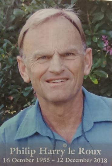
In memory of Philip le Roux, Estate Manager at Kirstenbosch from 1987, Curator since 1999, during whose tenure, significant for his passion, leadership & it's many innovations, the Gardens rose to even greater international acclaim. He sadly succumbed after an untimely cycling accident, passing on 12 December 2018. Philips' spirit will forever be entwined with the garden which was such an integral part of his life . . . truly a wonderful legacy & our special friend !

