海底堆積物と付加体/Submarine sediments and Accretionary prism
[JP]
日本列島の大部分は付加体により形成されたと考えられており、ここ平磯海岸は付加体が海上に現れる最前線の一つです。付加体とは何かについて下図を参照して説明します。
[EN]
It is thought that most part of Japan has been formed with "accretionary prism". Hiraiso coast is one of front lines where accretionary prism appears above the sea. What "accretionary prism is will be explained with reference to the figure below.

[JP]
Stage 1:マグマが海嶺(海底の割れ目)からあふれて固まり、海洋プレート(この場合は太平洋プレート)を形成します。海洋プレートは海嶺から離れるように移動します。この海洋プレートの移動を駆動する力の95%は、海洋プレートの他端が上図左側の海溝においてマントル内に落ち込むことにより生じる引張力であると考えられています。
Stage 2:海底火山の上に成長したサンゴ、有孔虫、円石藻などの死骸が海洋プレート上に堆積します。この堆積物は後に石灰岩となります。
Stage 3:徐々に陸地に近づくにつれて、陸上の火山からの火山灰が降り積もります。また、陸地から比較的遠い位置では、陸上から流されてくる砂や泥のうち、比較的沈降しにくい粒径の小さい泥が堆積します。但し、大地震などによって海底で発生する海底地すべり(タービディティ・カレント)や洪水などの作用により、陸地から遠い場所まで砂が運ばれて、泥層の上に砂層が堆積することがあります。長い年月をかけて何度も大地震や洪水が発生して泥層と砂層とが繰り返し堆積することにより、砂岩泥岩互層が生み出されます。
Stage 4:さらに陸地に近づくと、粒子の粗い砂が、火山灰や泥の上に堆積します。
付加体形成:海洋プレートが大陸プレート(この場合はユーラシアプレート)の下に沈み込むときに、海洋プレート上の種々の堆積物は、大陸プレートによってかきとられて混ざり合い、大陸側に盛られていきます。この盛られた地質は「付加体」と呼ばれ、日本列島の土台を構成しています。
[EN]
Stage 1:Magma coming out of oceanic ridge (fissure in the bea bed) gets solidated and forms oceanic plates (e.g. Pacific plates). Oceanic plates move away from the oceanic ridge. 95% of the force driving the movement of the oceanic plates is pulling force caused by the other end of the oceanic plate falling into the mantle at the oceanic trench (see the left side of the figure above).
Stage 2:Shells of dead organisms, like corals growing on submarine volcanoes, coccolithophore, foraminifer etc. deposit on the oceanic plates. The deposited sediment becomes limestone later.
Stage 3:With approaching to land, volcanic ashes from volcanoes on the land fall and deposit. In addition, when it is still relatively far from the land, among sand and mud coming from the land (e.g. carried by river flows), less sedimentable particles with a fine grain size, i.e. mud, deposit. However, due to turbidity currents (submarine land slides) caused by major earthquakes, and to floods etc., sand is carried far from the land and deposits on the mud layer already deposited. Over the years, many earthquakes and floods happen and sand layers and mud layers deposit alternately, thus generating a structure in which sandstone layers and mud layers alternate.
Stage 4:When approaching closer to the land, rough grained particles (sand) coming from the land deposit on the volcanic layers and mud layers.
Formation of accretionary prism:When the oceanic plate sinks under a continental plate (in this case, Eurasian plate), the sediments on the oceanic plate are mixed with each other and accreted onto the continental plate. The accreted sediments are called a “accretionary prism” and form the base of Japan.
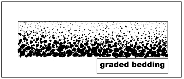
級化層理/Graded bedding
[JP]
様々な粒度の石、砂や泥が混ざったタービディティ・カレント(混濁流)により運ばれた堆積物によって形成されるタービダイト中には、「級化層理」が発達していることが観察されます。
級化層理とは、粒径が大きな粒子ほど早く沈降することに起因して、単層の断面で,下から上に向かって堆積粒子の粒径が粗粒から細粒へと連続的に変化する構造を言います(下図. Washington State Colleges websiteから引用)。長年にわたり何度もタービディティ・カレントが発生することにより、下図の級化層理が複数繰り返された構造となります。粒径の変化の方向を観察することによって、その層が水中で堆積した際に、どちらが上向きだったかを判断することができます。
[EN]
In turbidite, a type of rock formed with sediments carried by turbidity currents with mixture of particles having a range of grain sizes, like stones, sands and mud, you can observe that "graded bedding" was developed.
Graded bedding is a structure in which, because the larger the particle size is, the faster the particle settles out, the grain sizes of the sediment particles gradually change from the base of the bed to the top (see the figure below. Cited from the website of Washington State Colleges). Repetition of turbidity currents results in a stack of such graded bedding structure. By observing the direction of change of the grain sizes, you can tell which is the upper direction of the bed when it settled out in the water.
Found logのためのタスク/Task for claiming your Found log
[JP]
以下のQ1-Q4に対する回答をキャッシュ・オーナーに送ってください。
[EN]
Send the cache owner your answers for Q1-Q4 below.
Q1.
[JP]
公開座標付近では、下の写真のように、一定方向に傾斜しているタービダイトの地層を観察することができます。このタービダイトが海中で堆積した当時、上側だったのは下の写真中でAとBのどちらの方向でしょうか?
[EN]
At the published coords, as shown in the picture below, you can observe strata of turbidite, which are inclined at the same direction. Which of A and B in the picture was the upper side of the strata when they were deposited under the sea?
Q2.
[JP]
あなたのQ1の答えの理由は何でしょうか?
[EN]
what is the reason of your answer to Q1?

Q3.
[JP]
Additional Waypoint "Stage 2" を訪れましょう。ここでは、下の写真のように、公開座標付近(Stage 1)と比べて波による浸食が進み、比較的平らな地形になっています。Stage 1と2において、このような違いが生じるのは何故でしょうか?両地点における岩石の性質の違いを観察して回答してください。
[EN]
Visit Additional Waypoint "Stage 2". Here, as shown in the picture below, you can see relatively flat terrain resulting from wave erosion compared to at the published cords (Stage 1). Why has such a difference happened? Answer with taking into account a difference in characteristics of rocks between Stage 1 and 2.
Q4.
[JP]
Q3で観察した岩石の性質の違いから考えて、Stage 1の地層とStage 2の地層は、海中で堆積した際の陸地からの距離が異なると考えられています。Stage 1の地層とStage 2の地層のどちらの方が陸地からの遠い位置で堆積したと考えられるでしょうか?その理由は?
[EN]
Considering the difference in the characteristics of the rocks, the strata at Stage 1 and Stage 2 were deposited under the sea at different distances from each other. Which of Stage 1 and Stage 2 was deposited at the farther distance from the land? What is the reason why you think so?
