
Mow Cop Castle
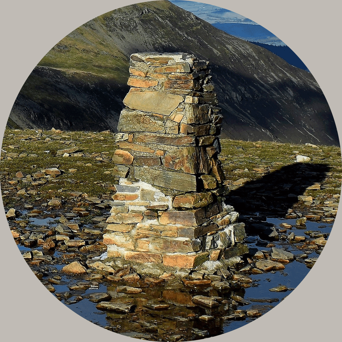
The trigpoint for Mow Cop stands proud on the top of the gritstone and all around it are are extensive quarries which you are free to explore. This EarthCache explores the rock you find here and what it was used to create.
Background Geology...
Firstly, let me give you some history of the general geology around here. The distant history of the planet is split off into many different periods during which the geology of the country underwent many significant changes. One of these periods is the Carboniferous Period, - here we are talking about the period in our history between 360 and 285 million years ago – so basically, a long, long time ago.
North and central England lay in equatorial latitudes (circles parallel to the equator) and around here we underwent a period of sagging in the earth’s crust, forming a vast basin of deposition which is known as the ‘Central Province’. The amount of subsidence increased towards the centre of the basin and probably reached its maximum somewhere in the general area of Manchester, where it amounted to several thousands of feet in total. So here at Mow Cop, we are located fairly close to the centre of the basin - and this is reflected directly in the nature of the Carboniferous rocks. This means thick and unbroken coal seams underground, but we are more interested in the surface rocks.
The oldest rocks of Carboniferous age in this area are the limestones of the Astbury area near Congleton. Sat on top of the limestone is approximately 2,000 ft (600m) of shales and sandstones of what as generally known as the Millstone Grit Series. This takes its name from the coarse sandstones that occur at the top of the succession which have in the past been quarried for millstones. These coarse sandstones can be readily observed at the surface here at Mow Cop where scours in some of the rock faces identify places where large rounded blocks have been hewn for millstones.

The Old Man of Mow
You can find this famed rock to the north of the castle at the second waypoint near to the trigpoint.
So what about the Millstones?
Millstones are fairly famous in this area. A millstone is a special stone used in grist mills - for grinding wheat or other grains. Millstones come in pairs. The base (or bedstone) is stationary stone. Above the bedstone is the turning ‘runner stone’ and this actually does the grinding. The runner stone spins above the stationary bedstone creating the "scissoring" or grinding action of the stones. A runner stone is generally slightly concave, while the bedstone is slightly convex. This helps to channel the ground flour to the outer edges of the stones where it can be gathered up.
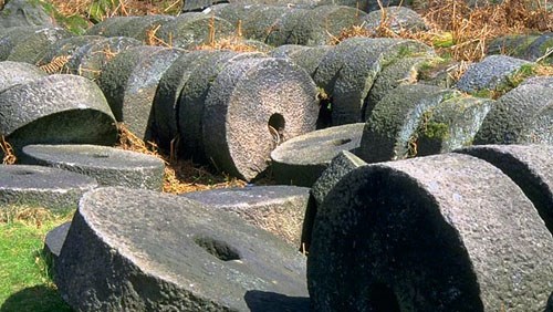
Peak District Millstones
The millstones made in this area were usually created using a specific coarse sandstone which was created in the Namurian strata of the Carboniferous period mentioned above. This rock is commonly known as ‘Millstone Grit’. Generally, these stones came from the Peak District and were monoliths – that is, a single piece stone. The rival millstones were generally segmented millstones, usually French burrstones from near Paris - in the case of those, the rock was in sections and cemented together and bound with iron bands.
Let’s compare Millstones –
French burrstones: Consist of fine-grained re-crystallised quartz desposits from the Tertiary period (65.5 million to 2.6 million years ago - so much newer stone than our Carboniferous stone) – generally used for white flour as the stone was better for separating the wheat grain components
Peak District millstone grit: Fine/coarse sandstone, from the Carboniferous Period (360 and 285 million years ago) – generally used for barley and animal fodder.
So what went on at Mow Cop?
We know the workers here once quarried stone to make into quern stones - made here since the Iron Age for milling corn. This trade ended during the Victorian period. Quern stones were the non-mechanised version of the millstone which essentially replaced them in milling production.
We know the quarry here at Mow Cop dealt in Millstone Grit from the Namurian strata which is a specific period of the Carboniferous time, 326 to 313 million years ago. This Millstone Grit isn’t exactly the same as that found in the Peak District, but it is clear millstones were made here – there are unfinished millstones to be found attached to the quarry face. However, the geologists have looked and they are of very poor quality – therefore, it’s likely that like the neighbouring castle, the millstones you see here were only ever intended to be ornamental.

A Mow Cop Millstone at Alderley Mill
Studies have been made however and documentary evidence of millstone manufacture has been found linking seven mills as having ‘Mow Cop’ stones. Nether Alderley, Leek and Stretton are open at times still to the public. The interesting point seems to be that these stones were segmented and raises the question – why were segmented stones made at Mow Cop? They weren’t ever segmented in the Peak District and it would not have improved grinding quality.

Millstones from Mow Cop - sketch by Julie Ballard
To log this earthcache:
You will not find all the answers standing at the given co-ordinates, they only bring you to the quarry as an unspecific point. You need to walk about through the quarry and look at different areas of the rock face.
You should now act as geologist and then send me a message through my profile (e-mail please rather than messenger). You should send your message before logging or soon after or your log could be deleted. You are not expected to necessarily get all the answers spot on, but please make a good effort. If you make notable errors I will reply with the correct answer.
(1) Why do you think the millstones produced here at Mow Cop are segmented when the Peak District stones were not?
It could be you think it was purely ease of transport or making use of rock originally intended for something else. However, if you study the rocks here you may or may not find other evidence.
Take a close look at the quarry faces here at Mow Cop.
- (1a) Can you see evidence of faulting? (fractures or discontinuities in the rocks)
- (1b) If you can see faulting, look more closely. Is there any evidence of slickensides? (a slickenside is a smoothly polished surface caused by frictional movement between rocks along the two sides of a fault. This surface is normally striated in the direction of movement)
Please explain to me what you see and how this might help answer the above question.
It may be that you are familiar with the millstone grit of the Peak District – see the above photograph of Peak District Millstone if you are not.
(2) In summary, can you tell me what you feel the key differences are between this area of Mow Cop millstone grit and the Peak District millstone grit, and how this might impact the millstones that were produced here?
(3) Finally, take a visit to the nearby Mow Cop Castle (folly). Take a close look at the stone. Do you think it was built of stone from this quarry or from elsewhere?
(4) Please relocate to the trigpoint (waypoint provided) which proudly stands upon the Gritstone you have been examining. You can also see the 'Old Man of Mow' here, a spectacular 20 metre high column of gristone spared by quarrymen, likely due to its structural integration or as a boundary marker, which has been shaped by centuries of weather. Please take a photograph or yourself or a personal item with the trigpoint and include it with your log.
Many thanks to the National Trust and specifically, Countryside Manager Chris Widger, for granting permission for this EarthCache to be published.
About Ye Ole Survey Monuments
|
 |
Ye Ole Survey Monument (YOSM) is a captivating series of caches that pays homage to the remarkable legacy of OutForTheHunt's YSM series (GC45CC).
YOSM caches are strategically positioned at or near Trig Points. These triangulation stations have played a pivotal role as surveying landmarks, contributing to the mapping of expansive territories.
Some of these points, bearing historical significance, might now be situated on private land or have vanished with time. As a result, the caches are artfully placed in close proximity, reverently acknowledging the historical importance of these survey monuments.
|
More information, bookmarks and statistics can be found at the YOSM Website
If anybody would like to expand the Ye Ole Survey Monuments Series, please do.
I would ask that you request a number for your cache first at www.yosm.org.uk
so we can keep track of the numbers and names to avoid duplication.