Civita di Bagnoreggio - Dying City
Important note as of 20.10.2025:
It seems the info panel has been removed and will hopefully replaced soon. The answer for this earthcache however can also be researched on the net, thus the cache can still be solved. Sorry for the inconvenience.
Italiano:
Dichiarazione geologica:
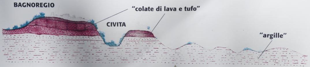
Le forre sono stretti valloni con pareti a strapiombi , che l'acqua ha scavato nel corso dei millenni nel tufo e nelle lave. Queste sono rocce vulcaniche effusive eruttate dal complesso vulcanico vulsino tra 1 milione e 300.000 anni fa, che ricoprirono con uno strato omogeneo tutti i materiali preesistenti.
Sotto di esse infatti troviamo, dal basso verso l'alto, e quindi dalle rocce più recenti, prima le argille, despositate tra 1,7 e 0,7 milioni di anni fa (Pliocene) in ambiente marino, poi le ghiaie.
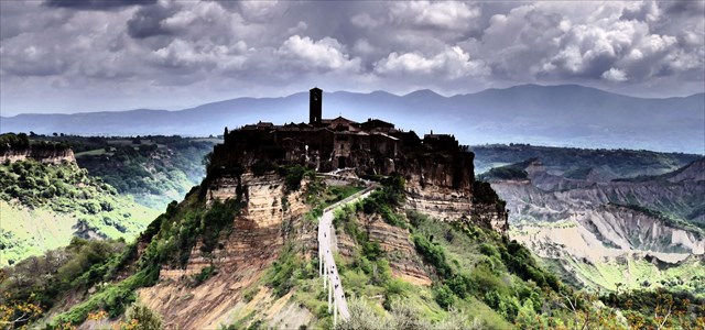
Tra le zone dove questa statigrafia è particolarmente evidente ci sono quelle di Civita di Bagnoregio e di Civita Castellana, dove il paesaggio è modellato anche dalle caratteristiche forme dei calanchi, che si presentano come dei profondi "tagli" nei fianchi dei versanti sui quali non riescono a crescere le piante per la continua erosione.
I calanchi si sono originati, presumibilmente, nel periodo postglaciale, durante il quale i fiumi avevano maggiore portata e maggiore forza e quindi innescarono fenomeni erosivi nelle argille per la loro scarsa resistenza. Tale erosione prosegue ancora oggi, per cui i calanchi continuano ad offrire una straordinaria testimonianza degli eventi geologici del passato.
Permesso di registro:
Per registrare questa cache prega di rispondere alla seguente domanda per la visita (Il panel (vedi waypoint) aiuterà):
Quale cratere si chiama in bacheca, la lava ha inondato il livello ("Cratere di ...")?
Per l'autorizzazione del registro, inviare una e-mail a gc5tnya_RISPOSTA@droescher.eu e sostituire la parola RISPOSTA con parola che stai cercando (Se per esempio la risposta è "Roma", usa gc5tnya_roma@droescher.eu). Scrivi il tuo nome utente come oggetto della posta.
Se tutto è corretto, devi ricevere una conferma dopo qualche minuto.
Se hai problemi con la risposta o ulteriori domande in merito a questo terremoto, ti preghiamo di contattarmi tramite geocaching.com modulo di contatto .
English:
Geological description:
The canyons around "Civita di Bagnoregio" are narrow valleys with steep cliffs, which were carved into the tuff and lava by the water over the millennia.
The volcanic stones emanated from the volcano Vulsino about 1 million to 300,000 years ago, and built a uniform layer covering all the existing materials. Below these lava flows, there is a layer of clay, created from 1.7 to 0.7 million years ago (Pliocene) from the sea, followed by gravel.
This is visible especially at "Civita di Bagnoregio" and "Civita Castellana", where the landscape was influenced by the formation of the canyons. Here the different rock types are visible in the "cuts" on the sides of the slopes. The canyons were probably formed in the post-glacial period, during which the rivers had greater expansion, and washed away the clay and gravel layer in a larger area.
Taking a closer look at the slopes of the Civita it get's pretty obvious why those villages are suffering from continous erosion:
While the Tuff and other lava stones on the surface are relatively stable, the lower layers of clay and gravel are loose and thus not stable at all. The erosion of these layers continues even today and leads to rockfall and rockslides at the steep slopes, so that the old city is threatened in its existence.
At the mentioned coordinates you have an excellent view of the canyon landscape and in particular the "Civita di Bagnoregio" as an impressive landmark in the fight against erosion.
Log Permission:
To log this cache please answer the following question on your visit (The information panel (see waypoint) will help):
Which crater is named on the info panel as the source of the lava that flooded the plains 1 million years ago ("Cratere di ...")?
For log permission, please send an e-mail to gc5tnya_ANSWER@droescher.eu and replace the word ANSWER with the word you are looking for (If for example, the answer is "Roma", then use gc5tnya_roma@droescher.eu). Please write your cachername as subject of the mail.
If everything is correct, you should get a confirmation after a few minutes.
If you have any problems with the answer or further questions regarding this earthcache, please contact me via geocaching.com contact form .
You do not need to wait for a log permission. If something is not correct, I will contact you for clarification.
Deutsch:
Geologische Erklärung:
Die Schluchten um "Civita di Bagnoregio" sind enge Täler mit steilen Klippen, die das Wasser über die Jahrtausende in den Tuff und Lava geschnitzt hat.
Die Vulkangesteine sind vor 1 Million bis 300.000 Jahren aus dem Vulkan Vulsino ausgeströmt, und haben mit einer gleichmäßigen Schicht alle vorhandenen Materialien bedeckt. Unterhalb dieser Lavagesteine finden wir erst eine Tonschicht, entstanden vor 1,7 bis 0,7 Mio. Jahren (Pliozän) aus dem Meer, dann folgt Kies.
Zu den Bereichen, in denen dies besonders sichtbar wird gehören "Civita di Bagnoregio" und "Civita Castellana", wo die Landschaft durch die Bildung der Schluchten beeinflusst wurde. Hier werden die Gesteinsschichten als "Schnitte" an den Seiten der Abhänge sichtbar.
Die Schluchten entstanden vermutlich in der Nacheiszeit, während der die Flüsse größere Ausdehnung hatten und dabei die Ton- und Kiesschicht großflächig weggewaschen wurde.
Bei genauer Betrachtung wird an den Hängen der Civita sehr deutlich wieso diese Siedlungen so unter der kontinuierlichen Erosion leiden:
Während der Tuff und andere Lavagesteine an der Oberfläche relativ beständig sind, sind die weiter unten gelegenen Ton- und Kiesschichten instabil und nicht so tragfähig. Die Erosion dieser Schichten setzt sich auch heute noch fort und führt zu Abbrüchen und Abrutschen der steilen Hänge, was die alte Stadt in ihrer Existenz gefährdet.
An den genannten Koordinaten habt ihr eine exzellente Aussicht auf die Schlucht-Landschaft und insbesondere auf die "Civita di Bagnoreggio" als beeindruckendes Monument im Kampf gegen die Erosion.
Lofreigabe:
Um diesen Cache zu loggen beantwortet bitte bei eurem Besuch die folgende Frage (Die Infotafel (siehe Wegpunkt) wird helfen):
Welcher Krater wird auf der Infotafel als Quelle der Lava genannt, die die Ebene überflutet hat ("Cratere di ...")?
Zur Logfreigabe sendet bitte eine Mail an gc5tnya_ANTWORT@droescher.eu und ersetzt das Wort ANTWORT durch das gesuchte Wort (wenn zum Beispiel die Antwort "Roma" ist, dann gc5tnya_roma@droescher.eu). Schreibt in den Betreff der Mail bitte eure(n) Cachernamen.
Wenn alles korrekt ist, dann solltet ihr nach wenigen Minuten eine Bestätigung erhalten.
Wenn ihr Probleme mit der Antwort habt oder weitere Fragen zu diesem Earthcache habt, kontaktiert mich über das geocaching.com Kontaktformular.
Ihr braucht nicht auf eine Logfreigabe zu warten. Sollte etwas nicht korrekt sein, melde ich mich zur Klärung bei euch.
Sources and additional information:

