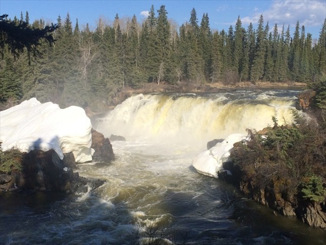
The name, "Pisew", is translated from the local Cree language meaning "Lynx". It was so named because the sound of the hissing water bears a resemblance to the sound of this wild northern feline.
Its creation is due to the intensive geological activity in the area hundreds of thousands of years ago, when violent tectonic effects caused the creation of first a fault, and then an upheaval of the southern side of the fault-line.
This has left a rift in the landscape with a waterfall riotously cascading over and through it.
Three types of tectonic fault lines
There are three kinds of faults: strike-slip, normal and thrust (reverse) faults, said Nicholas van der Elst, a seismologist at Columbia University's Lamont-Doherty Earth Observatory in Palisades, New York. Each type is the outcome of different forces pushing or pulling on the crust, causing rocks to slide up, down or past each other.
"Each describes a different kind of relative motion," van der Elst said.
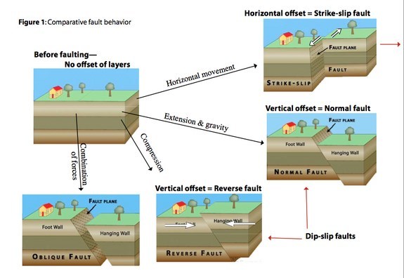
Strike-slip faults indicate rocks are sliding past each other horizontally, with little to no vertical movement. Both the San Andreas and Anatolian Faults are strike-slip.
Normal faults create space. Two blocks of crust pull apart, stretching the crust into a valley. The Basin and Range Province in North America and the East African Rift Zone are two well-known regions where normal faults are spreading apart Earth's crust.
Reverse faults, also called thrust faults, slide one block of crust on top of another. These faults are commonly found in collisions zones, where tectonic plates push up mountain ranges such as the Himalayas and the Rocky Mountains.
Strike-slip faults are usually vertical, while normal and reverse faults are often at an angle to the surface of the Earth. The different styles of faulting can also combine in a single event, with one fault moving in both a vertical and strike-slip motion during an earthquake.
All faults are related to the movement of Earth's tectonic plates. The biggest faults mark the boundary between two plates. Seen from above, these appear as broad zones of deformation, with many faults braided together. "Plate boundaries are always growing and changing, so these faults develop kinks and bends as they slide past each other, which generates more faults," van der Elst said.
Individual fault lines are usually narrower than their length or depth. Most earthquakes strike less than 50 miles (80 kilometers) below the Earth’s surface. The deepest earthquakes occur on reverse faults at about 375 miles (600 km) below the surface. Below these depths, rocks are probably too warm for faults to generate enough friction to create earthquakes, van der Elst said.
Micro-climate
Because of the continuous flow of water over the falls, the localized area has developed its own microclimate. A wide variety of mosses, lichens, and fungi can be found in the immediate area around the base of the falls. There are also a variety of ferns whose origins date back to before the last Ice Age. The dominant winter feature downstream and to the right of the falls is the ice that builds up on top of a small island there. This island only rises a few feet above the downstream water level in summer, but by late February, the ice accumulates to approximately 3–5 metres thick from the months of freezing spray.
At the periphery of this barrier between liquid water and frozen surroundings lies a thin ridge of plant growth that continues to survive throughout the harshest of the -45 degree Celsius days in this frigid northern wilderness. Normally the process of photosynthesis ceases in the surrounding area.
It is common to see one or more of the local otters using the large ice buildup as a "slide", providing the otters and lucky spectators with hours of amusement.
Manitoba Conservation asks that visitors keep the area clean and stay on the built observation decks and well away from the areas below the falls, which are marked as "Environmentally Sensitive".
As long as everyone co-operates in this respect, this remarkable piece of geography will be here for many generations to come.
Sources: Wikipedia, Pisew Falls Provincial Park; LiveScience
To claim this EarthCache as a find, you must email me through my profile the answers to the following questions:
DO NOT write your answers in your log posting! (Log postings with answers will be deleted)
1. What is the height of the Pisew waterfalls?
2. Pisew Falls is the second highest waterfall in Manitoba; name the highest waterfall in Manitoba?
A very nice observation platform was constructed from the parking lot to lower observation platforms, to prevent visitors from slipping or damaging Environmentally Sensitive plants and organisms. Please stay on the observation platforms.
3. What type of tectonic fault line do you think caused this rift in the landscape?
4. Calculate the height difference between the bottom of falls and the top (parking area) of the upheaval that was caused by the violent tectonic effects? Take an elevation reading at GZ (N 55° 11.831 W 098° 23.862) and then another at the start of the boardwalk (N 55° 11.892 W 098° 23.891). Add the difference to your answer from question 1 and you can assume GZ (boardwalk elevation) is 2m (6.7ft) above the top of the waterfalls.
5. Optional: Post a Picture of you and/or your GPS with the waterfall in the background.
IF I DO NOT RECEIVE YOUR ANSWERS WITHIN 2 WEEKS OF YOUR LOG, I WILL HAVE TO DELETE YOUR FOUND LOG, SORRY THAT IS THE REQUIREMENT OF AN EARTHCACHE.
CONGRATS TO goldfinch99 for being First to Find!