ENGLISH VERSION
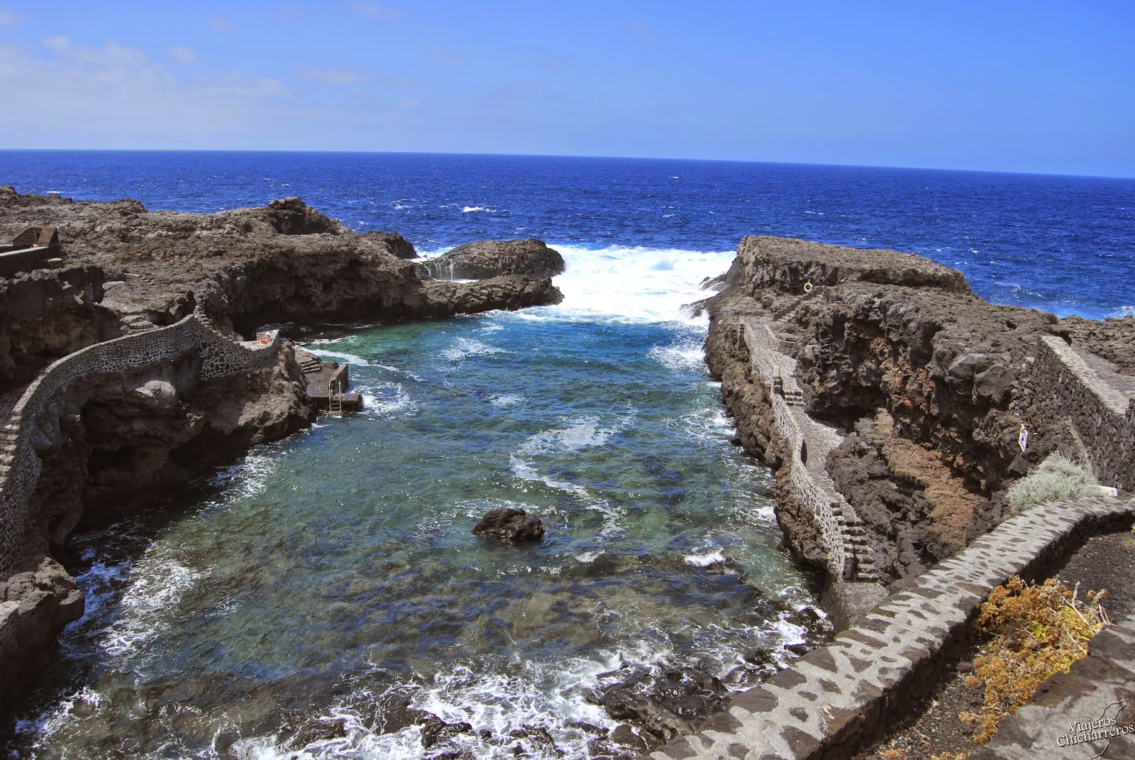
Charco Manso is a small bay with a natural pool of lava stone and crystal waters. It is surrounded by a unique and amazing landscape, where sea erosion has torn much of the volcanic coast for thousands of years to produce spectacular views.
With this Earth cache, a few meters around the natural pool, you can see most natural phenomena that occur when the sea eroded volcanic coast.
The coast takes different forms due to the constant sea erosion process to which they are subjected. Its forms are very diverse, and generally can be constituted by towering cliffs, ramps by lava that reach the sea, forming low islands, rocky coastlines or large fine black or yellow sand.
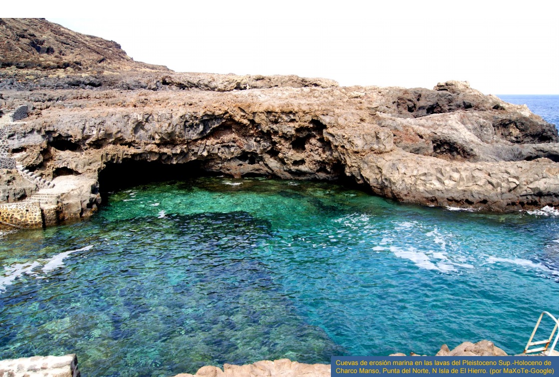
The action of the sea, wasting the cliff produces tiny cracks that increasing in size, they become sea caves. When pressurized water enters the cave, the air is compressed and it tends to go wildly over the top, accompanied by water spray, producing a kind of roar. This type of phenomena in the coast has been called "bufadero".

On the coasts with compact material, the formation of the cliffs is more or less uniform, giving an almost straight coastline. In the other side, where the rocks have different resistance then a different erosion is created and the weaker sections recede more quickly forming large entrees that are called bays or inlets, and the toughest sections are rocky redges or promontories called "roques".
If promontories remain beaten by waves, then caves on both sides are usually formed. These caves can be so deep that communicate with each other producing arches and natural bridges called "foradadas". These arcs can collapse and produce an island which is separated of the coast.

Questions:
You can log the Earth cache, in addition please send us a message with the answers of the three following questions:
a) What can happen when pressurized water enters a cave and goes wildly over the top?
b) Go to the main coordinates of the cache, you are in front of one of the most impressive 'views', What do you see?
c) Go to the natural swimming pool, how deep it is in average roughly?
Optional: If you like the place like we do, you will take a lot of pictures, just upload at least one with your log please.
- - - - - - - - - - - - - - - - - - - - - - - - - - - - - - - - - - - - - - - - - - - - - - - - - - - - - - - - - - - - - - - - - - - - - - - - - - - - - - - - - -
VERSION ESPAÑOLA
Charco Manso es una pequeña bahía con una piscina natural de piedra volcánica y aguas cristalinas. Está rodeada por un paisaje peculiar y sorprendente, en el que la erosión del mar ha arrancado gran parte de la costa volcánica durante miles de años para producir formas espectaculares.
Con este Earth caché, en pocos metros en los alrededores de la piscina natural, podréis observar la mayoría de los fenómenos naturales que se producen cuando el mar erosiona una costa volcánica.
La costa adopta diferentes formas debido al constante proceso de erosión marina al que están sometidas. Sus formas son muy diversas, y en general pueden estar constituidas por imponentes acantilados, por rampas lávicas que llegan hasta el mar formando islas bajas, por franjas costeras rocosas o por grandes playas de arena negra o amarilla.
La acción desgastadora del mar sobre el acantilado produce pequeñas grietas que, al aumentar de tamaño, se convierten en cuevas marinas. Cuando el agua entra a presión por la cueva, el aire de ésta se comprime y tiende a salir violentamente por la parte superior, acompañado de agua pulverizada, produciendo una especie de rugido. A este tipo de formación costera se le ha llamado hoyo soplador o bufadora.
En las costas con material compacto, la formación de los acantilados es más o menos uniforme, dando una costa casi recta. Por el contrario, donde las rocas tienen distinta resistencia se crea una erosión diferente y los tramos mas débiles retroceden con mayor rapidez formando grandes entrantes que reciben el nombre de bahías o ensenadas, y los tramos más resistentes constituyen los salientes o promontorios llamados "roques".
Si los promotorios siguen siendo golpeados por el oleaje suelen formarse cuevas en ambos lados. Dichas cuevas pueden ser tan profundas que llegan a comunicarse entre sí produciendo arcos o puentes naturales llamados foradadas. Estos arcos pueden derrumbarse y dar origen a un islote costero separado de la línea de la costa.
Preguntas:
Podéis hacer el log de este Earth caché, además por favor enviarnos un mensaje con las respuestas a las siguientes tres preguntas:
a) ¿Qué puede pasar cuando agua entra a presión por una cueva y sale violentamente por la parte superior?
b) Ir a las coordenadas principales del caché, estáis frente a una de las "vistas" más espectaculares, ¿Qué es lo que véis?
c) Ir a la piscina natural, ¿qué profundidad tiene de media aproximadamente?
Opcional: Si os gusta este lugar tanto como nos gusta a nosotros haréis muchas fotos, por favor subir al menos una fotografía junto con vuestro log.