TO CLAIM A FIND FOR THIS EARTH CACHE, YOU NEED TO ANSWER THE FOLLOWING QUESTIONS:
- In your own words, explain how a salt pan is formed.
- Which are the two predominant geological groups present in this part of the Kalahari?
- Why is Hakskeen Pan ideal for high-speed racing?
- Describe the appearance of the salt along the fenced area. How does it differ from normal table salt in terms of its colour, the shape and size of the crystal and the presence of impurities? (Post-publication note: A deep trench has been dug along the fence - not sure what the reason is, but access to the fence is now obstructed. But, why not use Google and see if you can still answer this question...?)
- Standing next to the road sign, what is your elevation? Compare that to the elevation at any other point while driving along the salt pan.
- Post a photo of yourself and your GPS device standing next to the road sign (optional).
Hakskeen Pan is a mud and salt pan and part of a cluster of more than fifty larger and hundreds of smaller pans located north of Upington near Mier in the Northern Cape Province. As a salt pan, it is reasonably average, however, it recently gained notoriety as the location for the Bloodhound SSC project’s attempt at a new land speed record.
 Bloodhound SSC is a British supersonic land vehicle currently in development. Its goal is to match or exceed 1,000 miles per hour (1,609 km/h) achieving a new world land speed record.
This pencil-shaped car is powered by both a jet and a rocket engine and its developers hope to break the current record by 33%, the largest margin ever.

But why Hakskeen Pan?
It basically comes down to how flat is flat...
When driving on a salt pan, it usual looks and feels flat – but what may feel like a small undulation at 100 mph could become a catastrophic bump at a 1000 mph.
A survey of Hakskeen Pan measuring the elevation level at 200 points, each 10 meters apart along a 2 km long straight line, made for some interesting reading. The total variation in elevation on this 2 km strip of desert is only 61mm making it as flat as flat can be.

Though the graph above may look like the surface of the Moon, imagine it stretched out over 2000 meters - it would look perfectly flat, making Hakskeen Pan the ideal place for the world’s first 1000 mph race track! And just to make sure no bumpy surprises crop up, around 300 previously unemployed local workers helped clear 6,000 tonnes of loose stones and rocks from the 2 km surface.

But, what is a salt pan and why is it so flat?
Salt pans are always found in arid areas with flat topography, low annual precipitation and long dry seasons with occasional flood events when episodic rainfall results in ephemeral river flow during the summer rain season. Rainfall in the area of Hakskeen Pan does not exceed 200 mm per year and often is considerably less not allowing for any surface run-off for several years. However, summer thunderstorms may be quite dramatic and much of the annual rainfall may occur once off and within a few hours. When the rivers run, the pans become flooded, but the sudden moisture is soon counteracted by the intense heat of the Kalahari and within days or weeks the water in the pans will evaporate, leaving behind a layer of clay, sand, pebbles and salt.
But how do the pans form in the first place, and how do they develop over time?
Pans owe their existence to the combination of a number of geomorphologic, geological and climatologic factors that favour their formation and development. Important pre-requisites are a flat terrain, semi-arid or arid conditions with seasonal (but then intense) rainfall, the right kind of rock type in the subsurface, and some tectonic events.
 Pans develop best on relatively soft rock types that are easily weathered and eroded, in order to provide the mud, sand and pebbles that we later find in the pans. Hakskeen Pan had formed in soft shales of the Ecca Group and tillites of the Dwyka Group, both being part of the Karoo Supergroup. Tillites are poorly consolidated moraines, which are rocks that form at the bottom of glaciers. They consist of components highly variable in size, including clay, silt, sand, and larger rock fragments.
Strange to see such rocks in the middle of a desert, but during the upper Carboniferous and lower Permian periods, about 300 million years ago, the area now known as the Kalahari was still part of the Supercontinent Pangaea and located much closer to the South Pole.

Compared to the age of the rocks from the Ecca and Dwyka Groups, the river systems and processes that have led to the formation of the Hakskeen Pan are geologically young and probably not older than Late Pleistocene and Holocene in age. Hence, the pan may have existed only for the last 10,000-20,000 years.
River systems in flat, arid terrains show poorly organised drainage patterns with meandering river beds changing directions frequently. Watersheds are often large and poorly defined. In order to form a pan some event needs to disrupt the drainage of such a terrain and allow water to gather in a certain place. Such an event could be tectonic movements that lift part of the area. In flat terrain not much uplift is needed to reverse the flow direction and effectively stop water drainage from the area. Migratory dune fields may also block or obstruct drainage. Once the water drainage is disturbed, shallow lakes may form.
Depending upon the intensity of the rainfall and the amount of water flowing, the rivers will erode mud, sand, and pebbles downstream and into the lake where all carried material comes to rest. Since further flow is not possible, the water currents within the lake are weak and the sediment load in the water can settle to the bottom undisturbed to form perfectly flat sediment layers. Subsequent evaporation will remove the water fairly quickly exposing the dry and flat plains to desert winds which in turn remove part of the sediments, leaving behind shallow topographic depressions. This is important in order to make space for new sediment brought in by the next flood event.
The intensity of annual floods will determine the kind of sediment transported in rivers and deposited in the pans. Weak water currents in the rivers will be able to carry clay and silt, and perhaps sand, but not coarse components like pebbles and boulders. The abundance of pebbles at Hakskeen Pan, however, indicates fairly intense flash floods in the recent past.
Once water has evaporated from the pan, sediment starts drying out, often forming characteristic mud cracks caused by contraction. The drying process also binds clay deposits to form a coherent, hard and flat surface - ideal for high-speed driving.
 Once the pan has completely dried over, loose sand, silt and clay are blown out by desert winds leaving heavier pebbles and boulders behind. The blown-out sand, clay and silt often form a characteristic lunette dune. These crescent-shaped dunes are typically found along the down-wind margins of the pan with the horns of the crescents pointing up-wind. Clay and silt further help to consolidate the dune and provide substantial cohesion between the particles preventing these dunes from migrating.
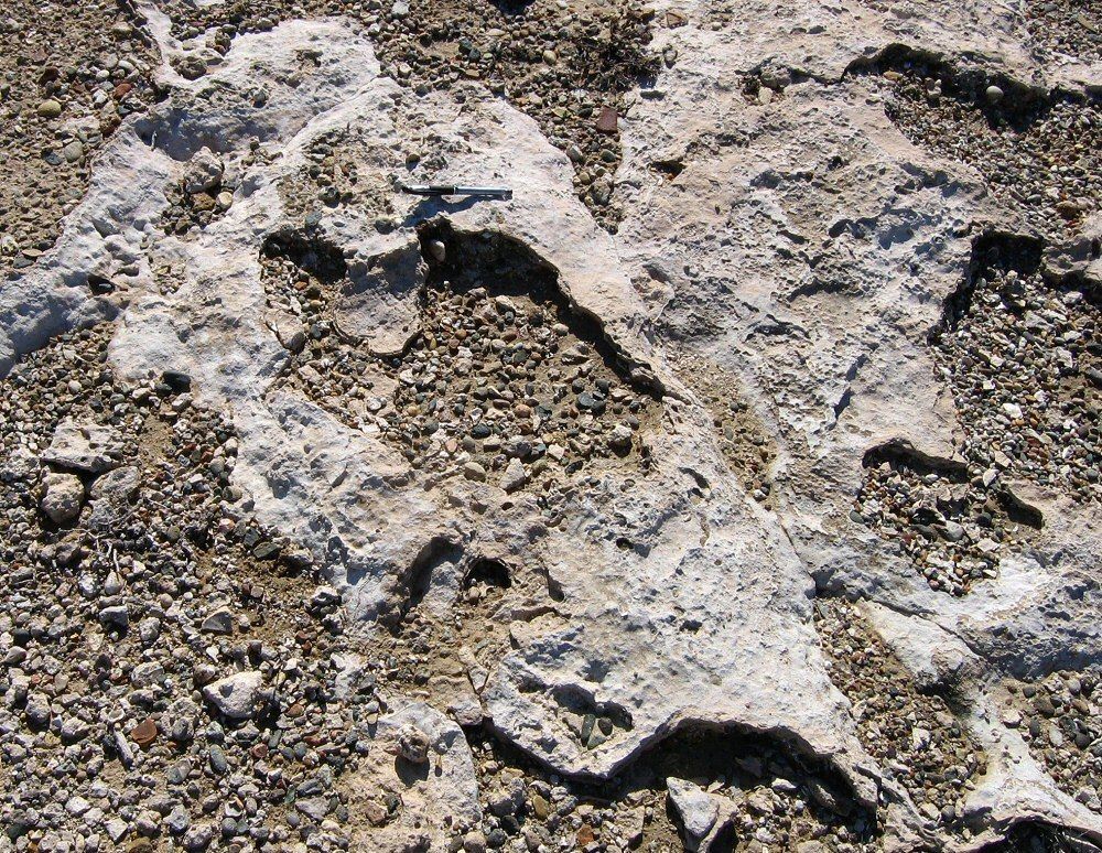 In Hakskeen Pan there are a number of large blocks of carbonate-rich, layered rock, which have not come there by transport in flash floods but have formed in-situ. These crusts of silt, sand, clay and carbonate minerals form by the rise and fall of the groundwater level beneath the bottom of the pan. This process influences the alkalinity of the soil and can promote the precipitation of carbonates. This forms layers and irregularly shaped bodies called calcrete, a fairly hard rock type that cannot be removed by desert winds.
Where the softer material around such calcrete blocks is blown out, the cemented calcrete might stand out of the ground, forming the only topographic anomaly in the otherwise flat plains of Hakskeen Pan.
References:
- The Geology of Hakskeen Pan (Dr Steffen Büettner - Geology Department, Rhodes University, SA)
- Wikipedia
- http://www.bloodhoundssc.com
Remember to accompany your log with an email as lonesome logs will be deleted.

Suikerbossies are a South African geocaching team.
You can follow our adventures on our Facebook Page Suikerbossies Geocaching Adventures.
| Suikerbossies have earned GSA's highest level: |
 |
