TO CLAIM A FIND FOR THIS EARTH CACHE, YOU NEED TO ANSWER THE FOLLOWING QUESTIONS:
-
List and describe each of the three major geological formations related to the stratigraphy of the Upper Karoo Supergroup seen in the park.
-
Estimate the average width of the dyke at Rooidraai? Describe the appearance of the Karoo dolerite and any metamorphic rock present along the dyke.
-
Look at the sandstone cliffs located next to the view point across from the road cutting. Explain the origin of the black stains running down the cliffs.
-
Explain why you think the cliff summit has a mushroomed appearance?
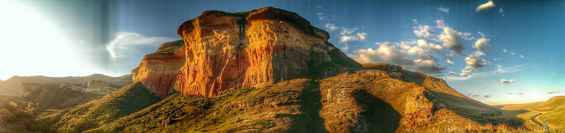
This Earth Cache will take you to Rooidraai (English translation “red bend”) in the Golden Gate Highlands National Park in the north eastern Free State. This is a perfect vantage point from where to observe:
-
The main geological formations seen in this area;
-
Karoo dolerite dykes and sills, and
-
Manganese staining.
Overview
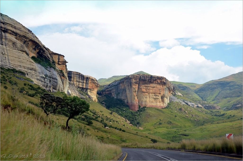
Nestled in the rolling foothills of the Maluti Mountains of the north eastern Free State lies the Golden Gate Highlands National Park. This 11,600 ha park derives its name from the brilliant shades of gold cast by the sun on the park's majestic sandstone cliffs.
Geology:
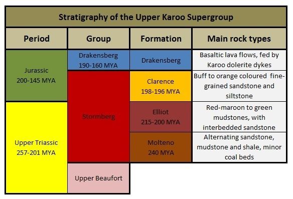 Part of the Karoo Supergroup, the geology of this area comprises the basaltic flows of the Drakensberg Group and the upper two sedimentary layers of the Stormberg Group.
The Stormberg Group is in turn subdivided into three formations – the lower Molteno, the middle Elliot Mudstone and the upper Clarens Sandstone, their layered sequence a perfect record of gradual desertification.
The bottom Molteno Formation comprising alternating layers of sandstone, mudstone and shale, was deposited around 240 MYA by fast-flowing rivers in a wet environment. This formation is not visible at this cache location and is best seen exposed as small cliffs in the lower Drakensberg and can easily be recognised by its sparkling appearance due to the presence of minute quartz crystals.
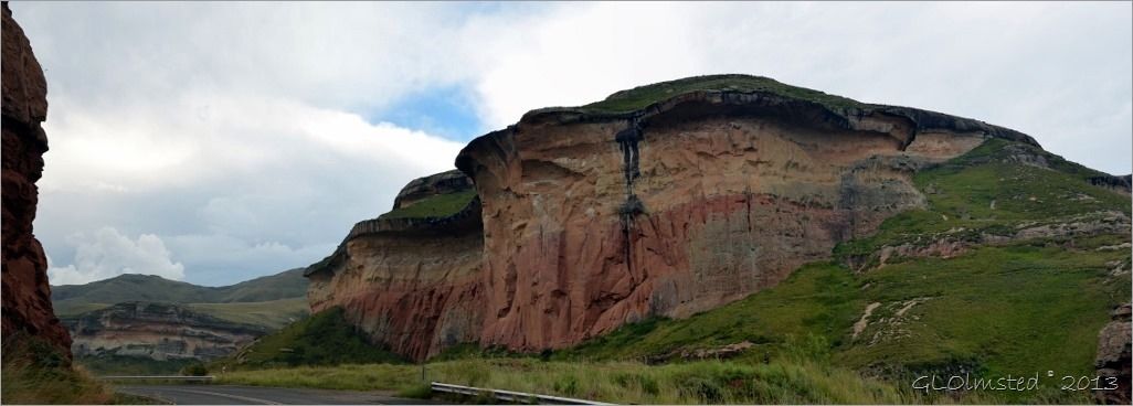
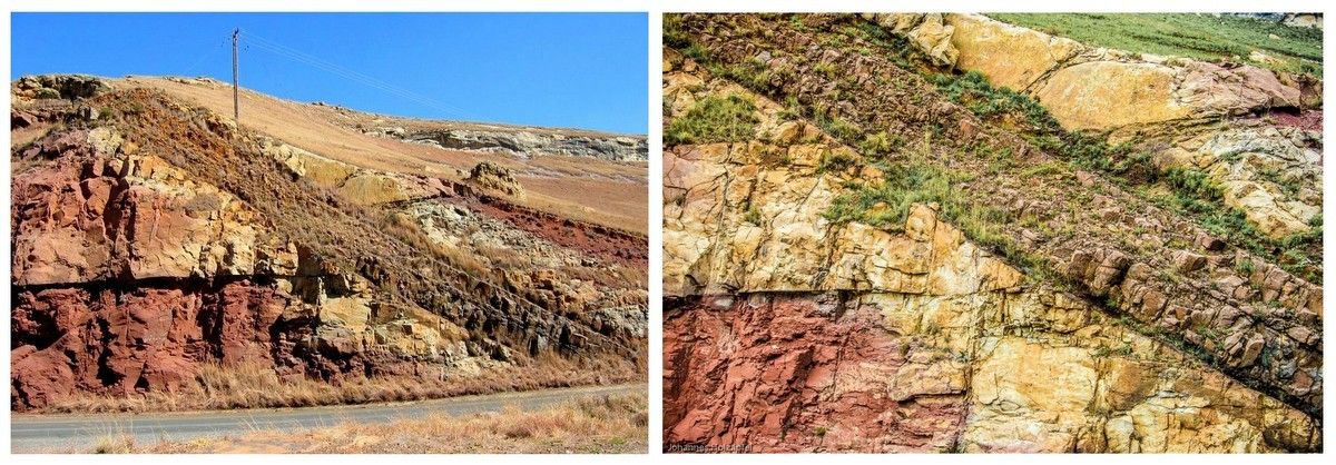
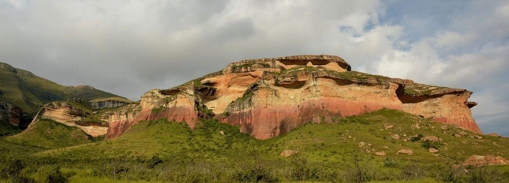
The middle Elliot Formation can be seen across the park as a reddish-maroon mudstone layer running along the lower foothills of the sandstone cliffs. This layer was formed by swampy river sediments around 200 MYA at a time the area was a wetland/flood plain. When rainfall dropped, the mud dried out and over time turned into rock. This mudstone is well known to contain wide variety dinosaur fossils.
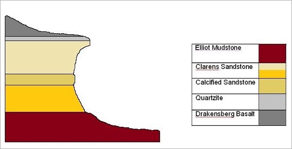 By 196 MYA, climatic changes had turned this area into a desert with layers of aeolian sand deposits that eventually lithified to form the characteristic ochre, yellow, buff and orange hued sandstone cliffs of the Clarens Formation.
Contained within the sandstone are harderned layers of calcified sandstone. These had formed when water moving through the sandstone had caused a build-up of calcium carbonate along some of the strata, cementing sand particles into calcified sub-layers.
The three layers of the Stormberg Group is topped off by a layer of volcanic Drakensberg basalt which had formed around 183 MYA when the area was volcanically active and sheets of molten rock had spread across the land and solidified into basalt. This igneous rock is very hard and erodes much slower than the sedimentary layers it overlies, resulting in the characteristic overhanging summit scarps across the park.
At the juncture between the igneous basalt layer and sedimentary sandstone, is a thin layer quartzite. This metamorphic rock had formed when the parent sandstone was exposed to and eventually transformed by the heat and pressure of the overlying volcanic activity.
Karoo Dolerite Sills and Dykes:
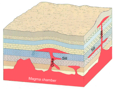 Around 175-180 MYA the supercontinent of Pangaea began to split into the southern landmass of Gondwana and northern Laurasia. This cataclysmic breakup triggered widespread volcanic activity that continued during the further breakup of Gondwana.
During this time, land surfaces were capped in lava flows. But not all molten rock had made it to the surface. As vertical cracks formed in the underlying strata, pressurised liquid magma forced its way up along these vertical and diagonal pathways. In areas where rising magma was unable to reach the surface to produce volcanoes, pressure would build up causing the molten rock to uplift the overlying layers of rock. As most of these overlying layers were sedimentary in nature, it was weakest along its stratified horizontal planes causing pressurised magma to be injected horizontally into these resultant gaps forming igneous sheet intrusions between the sedimentary layers.
Magma in these feeder channels coagulated to form vertical or diagonal shafts known as dykes, while the horizontal intrusion sheets are called sills. As these intrusions cooled quickly through contact with the surrounding rock, it solidified into very fine-grained granite known as dolerite. The sills and dykes are thus younger igneous intrusions into the surrounding older sedimentary rock.
Layers of sandstone, mudstone and shale adjacent to these intrusions were subjected to excessive heat and pressure, causing the parent rock to transform into different types of metamorphic rock. Sandstone would change into quartzite, while shale and mudstone would morph into a wide variety of hornfels.
Manganese Staining:
 Many of the sandstone cliff faces in the park display peculiar, black, vertical run-off stains.
These black stripes form where water carrying manganese (manganese dioxide) from the top basalt layer seeps out staining the rocks below.
This phenomenon can be seen across the park.
At Ground Zero:
The coordinates will take you to the Rooidraai viewpoint.
From the viewpoint one is treated to a beautiful sandstone cliff; its layering clearly visible across the cliff face with typical black manganese streaking.
Across the road from the parking area is an exposed road cutting passing through upper layers of the Elliot Formation revealing the characteristic reddish-maroon mudstone with few layers of interbedded sandstone. To the right of the cutting is a prominent, diagonal running dolerite dyke.
For more detail on the geology of Golden Gate Highland National Park and a related analysis of the geology of the Brandwag buttress, also do the nearby Earth Cache Golden Gate (GC21VPY).
“The Free State landscape gladdens my heart, no matter what my mood. When I am here I feel that nothing can shut me in, that my thoughts can roam as far as the horizons.”
– Former State President Nelson Mandela wrote in his autobiography Long Walk to Freedom.
References and photos:
- http://www.sanparks.co.za/parks/golden_gate/conservation/ff/geology.php
- Wikipedia
- Geological Journeys - Nick Norman & Gavin Whitfield
- http://geogypsytraveler.com/tag/golden-gate-highlands-national-park/
Remember to accompany your log with an email as lonesome logs will be deleted.
Suikerbossies are a South African geocaching team.
You can follow our adventures on our Facebook Page Suikerbossies Geocaching Adventures.
| Suikerbossies have earned GSA's highest level: |
 |