These are the historic churches you will be visiting.
St. Paul’s Anglican Church,

St. Paul's circa. 1920
On 5 September 1832 the Bishop of Calcutta consecrated the ground on which St Paul's Church stands. This was six days after the Governor of the Cape, Sir Lowry Cole, had approved the grant of nearly one-and-half hectares at the foot of Devil's Peak to the people of Rondebosch for the erection of an Anglican Church.
On the 16th February 1834 Sir Benjamin D'Urban officially opened the "Rondebosch Chapel". In 1845 the chapel was renamed Saint Paul's Church. In 1854 St. Paul's acquired glebe land which included Rondebosch Camp Ground (now Rondebosch Common), as well as what is today Park Estate. In 1884 extensions were completed; two transepts, a choir, sanctuary, Lady Chapel, priest's vestry and organ vestibule, were added to the original Sophie Gray building. Further modifications took place in 1964. The organ and choir were moved to a new gallery at the 'west' end; a new porch and vestibule extended the nave; and a new door built and dedicated to those who had fallen in World War II.

St. Paul's 2015
------------------------------------------------------------------------------------------------------
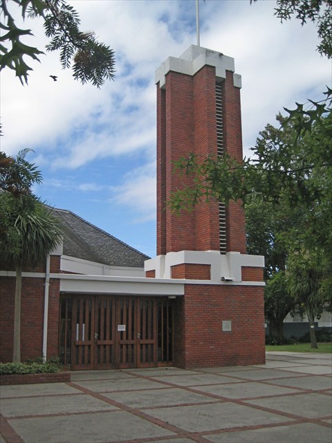
St Thomas Anglican Church
St Thomas’s Church was built in 1864-5, as a Mission Chapel in the parish of St Paul’s, Rondebosch. The original stone chapel, without chancel or transept, was built to a design by Sophie Gray (wife of Robert Gray, the Bishop of Cape Town) who was instrumental in designing some 40 stone churches in South Africa. The building was originally used as a mission school, but was extended by Herbert Baker in 1894 and modified by him again in 1903, and was formally dedicated on the 20th December 1903. The church was substantially enlarged in 1966 when the thatched roof was replaced by a tiled roof, the sanctuary enlarged and the North and south transepts were added.

St. Thomas' on Campground Road circa 1900

St. Thomas' 2015
------------------------------------------------------------------------------------------------------
St. Michael's Roman Catholic Church
In 1854 a piece of ground was purchased from the rouwkoop estate in rondebosch on the banks of liesbeeck river for the construction of a roman catholic church. The first attempt at building a church did not go well as a flood caused the initial building to collapse before it was completed: but this was accomplished in 1858. This church proved to be too small for the congregation and a new stone church was built and officially opened in 1886. This stone church was demolished in 1969 to make way for the present building.
St. Michael's 2015
------------------------------------------------------------------------------------------------------
The Rondebosch Dutch Reformed Church
On 9 November 1891 Sir Henry de Villiers, Attorney General of the Cape Colony laid the foundation stone of the church. A year later Dr. Andrew Murray consecrated the building. Several prominent Rondebosch schools owe their foundation to initiatives driven by this church, amongst these are Rondebosch Boys', Rustenberg Girls', and Groote Schuur.

Rondebosch Dutch Reformed Church circa 1920

Rondebosch Dutch Reformed Church 2015
------------------------------------------------------------------------------------------------------
The Rondebosch United Congregational Church
In 1900 a group of Congregationalists in Rondebosch gathered in the Rondebosch Town Hall, constituted themselves as a Church, and held services there for a time. They purchased a piece of land in Belmont Road and in 1903 the present building was opened for worship.

Rondebosch United Congregational Church 2015
------------------------------------------------------------------------------------------------------
This is what you have to do:
At the given coordinates locate the foundation stone that shows the year in which the church vestry was erected (ABCD) to mark the year that the church was established (EFGH). Substituting numbers for letters, proceed to:
Waypoint 2: S 33 5(A+D).(C+D)(D-A)(A-E) E 18 2(B-A).(D-H)(D/C)(B-C-D)
At this church find the year (JKLM), day (N) and month (P) that the foundation stone was laid. Determine the next waypoint:
Waypoint 3: S 33 5(L).(N+P)(J+L)(M) E 18 (K-L)(J+L).(N)(J)(P)
A simple task at this church; the foundation stone shows the year (QRST).
On to waypoint four:
Waypoint 4: S 33 5(R-Q).(R-2)(Q+T)(P) E 18 2(R).(R/2)(R-Q-T)(Q-T)
Another simple observation; on what day of the month (UV) was the stone laid?
Substitute to determine waypoint five:
Waypoint 5: S 33 5(R-T).(R-Q)(V)(U+V) E18 2(R).(V+2)(V+2)(T-U)
Here you need to determine the year (WXYZ) in which the Rector laid the stone for the parish hall. Once you have WXYZ the GZ coordinates of the final church and cache are easily determined substituting numbers for the letters of the alphabet used during this Rondebosch foundation stones tour.
FINAL: S 33 5(A+D).(P)(K-P)(X-Z) E 18 2(K).(W)(Z)(P-Z)