Español:
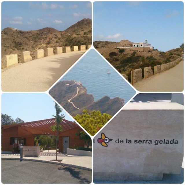
El frente litoral de la Serra Gelada está formado por imponentes acantilados que se elevan por encima de 400 metros sobre el nivel del mar. Deben su origen a la acción combinada de las fallas y la erosión marina.
Hace unos 70 milliones de años África se desplazó hacia el norte y colisionó con la península Ibérica, originando varias cadenas montañosas en Europa. Los materiales que forman la Serra Gelada se plegaron, dando como resultado la actual inclinación que obseramos en sus estratos.
Las rocas donde está la cueva del Bou tienen un color claro, son calizas. Si ahora miras hacia la parte más alta de la sierra por debajo de las antenas, podrás ver de nuevo estas calizas. Cómo es posible que las mismas rocas estén separadas por más de 170 metros en la vertical?
La respuesta está en una gran fractura o falla que provocó el deslizamiento de las rocas. Desde que se formó este relieve escalonado, el agua se ha encargado de esculpir y modelar las rocas en un proceso lento, pero constante, excavando los pequeños barrancos que tienes a la vista.
English:
The coastline of the Serra Gelada is made up of towering cliffs that rise more than 400 metres above sea level. They owe their form to the combined action of faults and sea erosion.
70million years ago Africa shifted northwards and collided with the Iberian Peninsula, creating a number of mountain ranges in Europe. The elements that form the Serra Gelada folded, resulting in the current slant that we can see in its strata.
The light coloured rocks of the Bou cave are limestone. If we look towards the top of the mountain just below the antennas, you can see this limestone again. How is it possible for these rocks to be vertically separated by more than 170metres?
The answer lies in a large fracture of fault that causes a shift in the rocks. Since this terraced terrain was formed, water has sculpted and shaped the rocks in a slow, but steady process, creating the small ravines that you can see here.
Español:
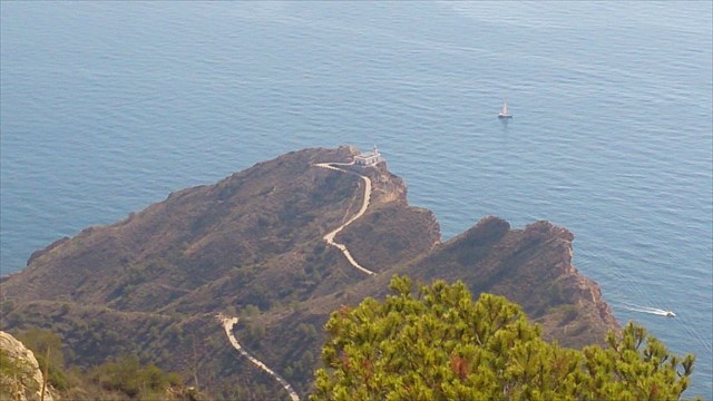
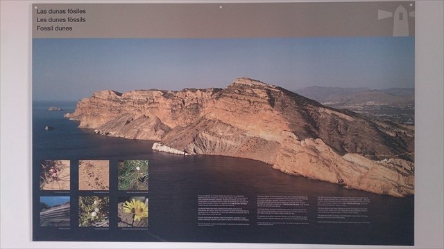
En los acantilados de la Serra Gelada encontramos una singularidad geológica de gran importancia, la duna fósil colgada. Está compuesta por unos materiales llamados eolianitas, depósitos de arenas que han sido transportados y acumulados sobre la base del acantilado por la acción del viento. Esta formación empezó a originarse hace más de cien mil años, cuando el nivel del mar estaba más bajo que el actual.
Las dunas fósiles de la Serra Gelada se encuentran entre las más importantes del mundo, tanto por su volumen de arena acumulado (que se aproxima a los 16 millones de m3), como por la altura que alcanzan (más de 200 metros sobre el nivel del mar).
En esta zona dunar se asientan varias comunidades vegetales de gran interés, al albergar especies que poseen un área de distribución restringida.
Con el fin de preservar al máximo este frágil hábitat, la duna posee una regulación especifica para poder transitar por ella.
English:
The cliffs of the Serra Gelada are graced by large and unusual geological features: hanging fossil dunes. Comprised of aeolianite materials – deposits of sands which have been born by the wind and stacked at the foot of the level of the sea was lower than it is today.
The fossil dunes of the Serra Gelada are among the largest in the world in terms of both height (over 200 metres above sea level) and volume of accumulated sand (approximately 16 million cubic metres).
The dune area harbours various interesting plant communities, including species not found in many other places.
In order to best preserve this fragile habitat, specific regulations govern access to the dunes.
Español:
Sabías estos hechos acerca de caminar en la Serra Gelada!
- Los fósiles de animales extintos se conservan en algunas rocas.
Los acantilados e islas en el parque eran escondites populares para los piratas berberiscos.
- Más de 50 especies de peces viven en las aguas.
- Hay plantas aquí que sólo crecen en esta parte del Mediterráneo.
- Hay que cuelgan dunas fósiles en los acantilados.
English:
Did you know these facts about walking in the Serra Gelada!
- Fossils of extinct animals are preserved in some rocks.
- The cliffs and islands in the park were popular hideouts for Berber pirates.
- More than 50 species of fish live in the waters.
- There are plants here that only grow in this part of the Mediterranean.
- There are hanging fossil dunes on the cliffs.
Information and opening hours Faro de l'Albir lighthouse and Museum. Cache will be accessible 24/7 Opening hours
Información y horarios Faro de l'Albir el museo. Caché será accesible 24/7 Horario de apertura

Para registrar esta caché.
Para llegar a registrar esta caché, tendrá que visitar y responder a las preguntas que se relacionan con las coordenadas dadas la Caché Tierra.
Cuando se recogen respuestas, enviarlos a CO para la verificación.
Puede iniciar sesión inmediatamente respuestas se envían CO. Si hay alguna pregunta sobre sus respuestas CO pondrá en contacto con usted.
Registros sin respuestas a co o con pendientes preguntas de CO serán borrados sin aviso.
Por favor, no incluir imágenes en su registro que pueden responder a las preguntas.
To log this cache.
To get to log this cache you will have to visit and answer the questions which are related to the coordinates given the earthcache.
When answers are collected, send them to CO for verification.
You can log immediately answers are sent CO. If there are any questions about your answers CO will contact you.
Logs without answers to CO or with pending questions from CO will be deleted without any further notice.
Please do not include pictures in your log that may answer the questions.

Preguntas.
Questions.
1. Responda a las preguntas siguientes visitando las coordenadas.
1. Answer the questions under by visiting the Coordinates.
Interrogación A: Qué se puede apreciar a nivel del mar al pie de los acantilados, y de cómo se formó?
Question A: What do you find at the foot of the sea level from the cliffs, and how was it made?
Interrogación B: Qué ángulo tiene la duna aproximadamente?
Question B: What degree in angle does the dune have approximately?
Interrogación C:Las dunas de la Serra Gelada se encuentran entre las más grandes del mundo respecto a su altura y volumen. ¿Sabría decir cuales son estas medidas?
Question C: The dunes of the Serra Gelada are among the largest in the world in terms of both height and volume. What are the numbers?
Interrogación D: Qué contienen y representan las cuatro capas que puede ver en lo alto de los acantilados y la montaña que se encuentran frente a usted?
Question D: What do the four layers contain and represent that you can see up at the cliffs and mountain ahead of you?
Interrogación E: Sabría decir que futuras fracturas podrían presentar los acantilados y cómo serían ?Como afectaría el nivel de erosión futuro a la forma de la montaña y los acantilados? Fíjese en el Sudoeste y describa lo que ve. Describa también cómo se verá en el futuro!
Question E: Can you say something about how the future fractures of the cliffs will be and look like, and how the future erosion level will form these cliffs and the mountain? Look South-West and describe what you see? And how it will look like in the future!
2. Tome una foto de sí mismo, el grupo o su GPS al iniciar la sesión la caché.
2. Take a photo of yourself, the group or your GPS when logging the cache.
Sin revelar ninguna respuesta!
Without revealing any answers!
(Es voluntaria para publicar una foto en su registro en línea)
(It’s voluntary to post a photo in your online log)
