Welcome to Headings Cliffs, Paringa
We find this area to be incredibly picturesque and amazing, it’s no secret that we like rocks and are always keen to learn more, if you are not rock lovers we think you will still enjoy the area and let out a WOW when you walk up and look out. So lets learn a little about the area together.
The area is very complex so we have tried to present this Earth Cache as a simplified version.
Well, we are looking at some rather impressive cliffs with some rather impressive colours of course but where do they come from and why are they here?
Lets start with the Eromanga Inland Sea.
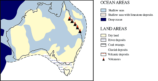
The Eromanga Sea existed in the Early Cretaceous period.
 *Don’t forget to refer back to this timeline when we talk about other periods further on.
Eromanga covered vast expenses of inland Australia inclusive of Queensland, the Northern Territory, South Australia, and New South Wales. Although the Sea hasn’t visibly existed in its above land watery state for Millions of years it still plays and important role as a part of the Great Artesian Basin.
Now lets look at something you may be more familiar with; the Murray Darling Basin.
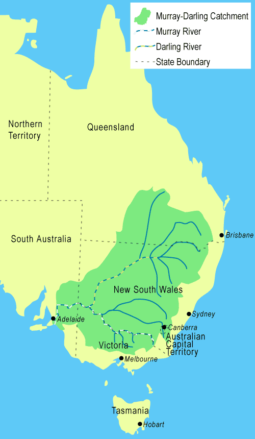
The Murray–Darling basin is a large geographical area in the interior of south-eastern Australia. The basin, drains around one-seventh of the Australian land mass. It spans most of the states of New South Wales, Victoria, and the Australian Capital Territory, and parts of the states of Queensland, South Australia. The basin is 3,375 kilometres in length, with the Murray River being 2,530 km long.
Now we are familiar with the Eromanga Sea and the Murray–Darling basin lets look more specifically at the Murray Valley and more specifically the Geology of this amazing area. The following information has been taken from Murray Valley Geology by Peter J Reilly.
Lets keep in mind some of the oldest rocks on earth are 4.5 billion years old, the majority of visible geological features in the Murray Valley in this area were formed within the last 30-million years. So, what you see here today is geologically speaking, a very embryonic landscape with many complex layers.
Geologists from around the world recognise the cliff-face exposures and landform features of this area to be classic examples of the Earth's development during the various epochs (stages) which make up the later half of the Cainozoic period; i.e. the most recent, 50-odd million years, of our planet's history.
These epochs or stages in relation to Murray Valley are explained below.
Lower Miocene (26 > 20Mbp):
An epoch during which ocean levels fluctuated. High ocean levels periodically inundated the Lower Murray Basin, creating a warm tropical sea, in which coral proliferated. At other times, when ocean levels fell, massive coral reefs were left exposed and were battered by the surf, wind and rain. Mannum, Finniss and Morgan deposits, all of which have their origin in ancient coral reef and sea bed debris, were all consecutively laid down during this era; clearly evident in their calcium-limestone structure, which is the residual concreted mass of coral, shell and the skeletal debris of ocean creatures.
* Mannum Formation: - Coral reefs, stranded by retreating sea-levels, were 'weathered' into limestone. The formation is crowded with the remains of tiny heart-urchins and other marine fossils. - It rises near Murray Bridge, attains maximum prominence in the Mannum region and tapers-off around the Marne/Big Bend section. - Though originally whitish, ground water and soakage have long since stained the strata a yellow/beige colour.
*Finniss Clay: - Rivers and creeks washed clay over the top of the stranded coral beds (nowadays know as Mannum Limestone). Depending on the location, the clay varies from zero to 2-m thick. It is particularly evident in the excavation work at the Mannum Pump House.
*Morgan Limestone: - The sea returned and coral proliferated. Types of fossil and nature of hard/soft layers indicate warm shallow seas and, probably minor, variations in sea level. - The 'minor variations', however, gradually accumulated to a hundred metres, or more, of water. - The strata is up-to 91m thick (300ft) in places and, like the Mannum Formation, it too has been stained yellowish by ground water. It exists as a minor top layer near Mannum and rises to towering prominence in numerous riverside cliffs between Big Bend and Overland Corner. - You simply can't miss it at Blanchetown, where it is exposed in vertical cliffs that rise 90-odd meters above the river; further upstream, the town of Morgan is built on top of it. - Between Murbko and Cadell, atop of the Morgan Limestone, but still part of it, there is a somewhat unique layer identified as the Cadell Formation, in which numerous specimens of fossilized cowry shells, dated at around 20Mbp, have been found.
Transition from Lower to Middle Miocene ~ ( 20Mbp).
Atop the Morgan Limestone lies a thin, greenish-grey glauconitic marl, which contains many calcareous tubeworm 'pipes' and separates the Morgan Limestone from a more diminutive layer known as 'Pata Limestone'. - Both the 'marl' and the Pata Limestone contain a type of plankton that evolved around 20Mbp. - Both these deposits are non-continuous, in that they do not cover the entire landscape, but they can be spotted at numerous locations within the Morgan to Waikerie section and can be identified by its greenish-grey colour and the presence of the tubeworm 'pipes'.
Middle Miocene (20 > 15Mbp). - The sea again retreated from the Murray Basin; the region reverted to 'dry-land', which exposed it to the effects of weathering and erosion. Along the coastline, wind and wave action pulverised the exposed shells and coral, producing massive quantities of calcareous (calcium-rich) sand and grit.
Upper Miocene (15 > 9Mbp). - Erosion and weathering of the exposed surfaces continued while, at the same time, below the surface, the vast bulk of what had been coral reefs, was being compacted, consolidated and turned into limestone. There is no doubt that erosion has obliterated and/or reshaped much of the surface topography. There is no evidence, therefore, of any notable sedimentation until the sea again returned at about the start of the Pliocene ~ (9Mbp).
Pliocene (9 > 2Mbp). -
Bookpurnong Beds, Loxton Sands, North West Bend Formation, and Parilla Sands were all laid down during this epoch. - The existence of oyster shells, indicates the sea again inundated the valley from time to time.
** Bookpurnong Beds (9 > 7Mbp). - An impervious clay-like stratum consisting of glauconitic shelly marl typical of river delta sediment; a clear indication of a Pliocene coastline. - It is most evident in the Loxton district, where a distinctive 3m (10ft) layer can be seen at a sharp river-bend 1.5Km (1.0ml) upstream of Katarapko Creek outlet. - The marl has become integrated and overlain with a 60cm (2ft) layer of pale calcareous sand (now sandstone). The stratum is rich in preserved shallow water shells and plankton.
** Loxton Sands (7 > 5Mbp). - Sea retreated and a bright yellow micaceous sand/grit mix was blown and/or washed over the Bookpurnong Beds. It is very widespread, is only partially consolidated and varies greatly in thickness. There is a very obvious 15m (50ft) layer adjacent to the Loxton Pump House - At this time, the region's topography would have resembled a Simpson Desert type landscape of Loxton Sand extending all the way down to the Pliocene ocean, with the sea intruding, estuarine fashion, between the sand ridges, as evident from the pockets of oyster shell that can be found among what would have been, at the time, primeval coastal sand dunes.
** North West Bend Formation (5 > 2Mbp). - Consisting of fossil sandstone, worked over sand/limestone mixes and thick oyster beds (same shells as above). - It occurs on top of Loxton Sands or sometimes directly on Morgan Limestone. It extends from Waikerie down to Tailem Bend. - The result of sediment left behind after the most recent sea incursion, which was colder and more suited to oysters than coral, and which formed a North-South estuary, more-or-less, coinciding with the current shape of the Lower Murray floodplain. - At Waikerie the sandstone is quarried as building stone and is used in many of Adelaide's old city buildings.
** Parilla Sands (5 > 2Mbp). - Concurrent with the above, on the north and east shores of the above estuary, extending all the way down to Keith and back into Victoria. Massive quantities of fine-to-medium quartz sand was drifting and 'dunning' far and wide across the landscape. - It was also accumulating along the creeks, in rivers and in the lakes that existed at the time. - This sand is now a semi-consolidated, pale, sandy stratum, which varies greatly in thickness, up to 15m (50ft) thick in places. - It appears as a dominant feature in many river cliffs between Loxton and the NSW border, and is especially prominent in the Chowilla to NSW border region. It is often 'capped' by a hard, centimeter-thin, silicified quartz layer, which formed later.
Pleistocene (2Mbp > 35,000bp): -
The first half-million or-so years of this epoch were free of further sedimentation and were characterised by widespread 'silicification' and 'ferruginisation' of the exposed land surface. This indicates that there was enough light-rainfall, or fog/mist or dew, to wet the landscape, but not enough to result in any sort of 'run-off' of the type that can moves sediment. The combination of repeated and periodic surface wetting, which dissolves any mineral salts present in the soil, followed by high-temperature induced rapid re-evaporation, results in a thin concrete-like 'skin' forming on unconsolidated soil surfaces. - Dare I say, conditions not dissimilar to those we nowadays see in the Simpson Desert, where the same process continues to create what we know as 'claypans' .
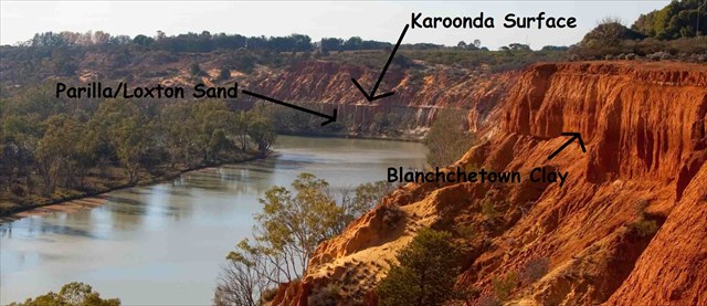
Eons later, whenever these very-thin but concrete-hard, ancient surfaces are re-expose. They are, very obviously, very much better at resisting erosion than are any 'un-concreted' materials that surround them. - The erosion resistant 'skin' that was formed on the land surface at the onset of the Pleistocene has since been named the 'Karoonda Surface' and, although it is discontinuous, it is very widespread and it conveniently marks the time break between the older
Pliocene, and the younger Pleistocene epochs. The silicified quartz capping, mentioned above, on the Parilla Sands, was formed at this time, (2 > 1.5Mbp).
At around 0.5 million years into the Pleistocene (~ 1.5M-bp). Torrential downpours began falling on what had, until now, been a semi-arid, wind-shaped landscape. The resulting floodwaters triggered a significant increase in the water-borne sediment 'flooding' into the Murray/Darling Basin. -- Some of the more notable formations thus formed ought to be recognisable, IF they are present in your location: -
Blanchetown Clay: - Around 1.5M > 1Mbp: - Floodwater carried huge quantities of high-silicate-content sediment, which when immersed in water becomes hydrated and forms clay, into the greater Murray Basin. - In the SA/NSW border regions there is now a 15m (50ft) layer of this 'clay' lying directly atop the Karoonda Surface; and it exists to a greater or lesser degrees, throughout the rest of the Murray Basin and into Victoria. - Characteristically the stratum appears as 'pale beige' colour at the top, grading to 'Uluru-red' at the bottom. - At the same time as this clay was being deposited in the greater Murray Basins, so-called 'Ape-man' inhabited the planet.
Bungunnia Limestone: - Around 1.2 > 0.7Mbp - Northern ice masses once again increased draining water away from the world's oceans. Sea levels dropped and wave action pounded the exposed coral and shell beds. Prevailing winds then blew the coral/shell debris far and wide over S.A.. ~ In the Murray Basin much of it ended-up in Lake Bungunnia and in the many creeks and swamps that existed at the time, where it was converted into a coarse freshwater-limestone. This chalk-like stratum varies greatly in thickness and location, it usually lies on top of or is interleaved with Blanchetown Clay. - It extends from as far south as Murray Bridge all the way up to Renmark; i.e. an area that corresponds roughly, in size and shape, to the prehistoric 'Lake Bungunnia' indicating how the ancient lake, although wholly located some ways north of 'Murray Bridge', covered an area equivalent to twice the size of Gulf St. Vincent.
Rippon Calcrete: - Concurrent with the above. The dry land surfaces now rich in calcium, from the same coral/seashell debris cited above, was subjected to repeated wet/dry weathering and the resulting calcrete surfaces, so formed, was very widespread; - So! By 100,000bp, a wind resistant calcrete surface, whitish and rather lumpy in appearance, covered the entire southern half of South Australia. It has been named the Rippon Surface. ... 'Calcrete' produced in this manner commonly resembles great 'dollops' of old style lime-mortar.
On top of the above, marginal and fragmentary layers continue to form. Forces of wind, rain, drought and flood can repeatedly move these deposits about, mixing and/or redepositing old material on top of new, churning the whole into a hotchpotch that can change from year to year. In this synopsis we will simply call the hotchpotch 'Conglomerate' for it is rarely more than a meter or so thick, oftentimes only centimetres and which, in addition to the above, is also subject to the aberrations of native flora and fauna, as well as agriculture and horticulture activities.
Now that is as clear as mud – pardon the Pun, ha ha ha. I think you will agree that the area is made up of complex layers that are extremely visible along this section of the river.
We learnt a lot while putting this EC together and because we want you to enjoy the area and not to be stressing over complex EC answers we have made it easier on you, we have put together a quick example of the layers clearly visible in the area.
To log this cache please use your own judgment and the information provided above to answer the following questions and send us your answers to the best of your ability;
1. Name three colours you can see in the cliff formation and suggest why they are these colours?
2. How far down the cliff face is the closest visible Karoonda Layer?
3. What is found in the Parilla Sands layer?
4. A photo of your team, GPS near GZ with your log and answers. (optional)
You are welcome to log your answers straight away to keep your TB's and Stats in order but please message us with your answers. Cacher’s who do not fulfil the Earth Cache requirement will have their logs deleted.
We hope you enjoyed the area and learnt a little along the way. Happy Caching!
Sources: http://users.esc.net.au/~pereilly/geo.htm, Geological Society of S.A, Primary Industries and Resources South Australia.

