Localización
"Tres Mares" es una cumbre mítica muy accesible, ya que la carretera más alta de Cantabria llega al cercano mirador del Chivo. En época invernal se puede acceder con los remontes de la estación de esquí de Alto Campoo o practicando la modalidad de esquí de travesía o raquetas de nieve. El "Picu TresMares" es una montaña perteneciente a los Montes de Campoo-Valderredible (llamado Circo de Alto Campoo), situado entre la comunidad autónoma de Cantabria y la provincia de Palencia, España. Tiene una altitud de 2175 m, desde lo alto de la montaña son observables las cuatro sierras de Alto Campoo y Fuentes Carrionas, así como una gran parte de los Picos de Europa.
Es la única montaña dentro de la Península Ibérica que vierte aguas a los tres mares que bañan la Península Ibérica. En Pico Tres Mares nacen tres ríos, y cada uno discurre por una cuenca distinta, llegando sus aguas a tres mares diferentes:
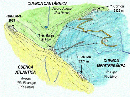
-Río Nansa (hacia el norte), que desemboca en el Mar Cantábrico.
-Un afluente del Río Pisuerga (hacia el suroeste), que a su vez es afluente del Río Duero, que desemboca en el Océano Atlántico.
-El Río Híjar (hacia el sureste), cuya surgencia kárstica en Fontibre da lugar al nacimiento del río Ebro, que desemboca en el Mar Mediterráneo.
Geomorfologia
El arco formado por las Sierras del Cordel y de Híjar, que confluyen, como es sabido, en la cumbre más significativa del valle, Tres Mares, constituye un medio de montaña caracterizado fundamentalmente por el contraste entre las cumbres y el fondo de valle, y por su adscripción a la vertiente meridional de la montaña cantábrica.
El relieve de Alto Campoo se explica por la evolución morfoestructural, es decir, el plegamiento, elevación y fracturación de los materiales mesozoicos que forman la cobertera en Campoo, por el comportamiento de éstos frente a la erosión y por el modelado reciente (ejercido por los ríos, glaciares y la gravedad actuando sobre las laderas). Su fisonomía actual es fruto de una larga evolución, en la que intervienen primero la formación de las rocas y su disposición, en un ciclo de más de 200 millones de años, y, posteriormente, en un ciclo más corto, en torno a un millón y medio de años, la erosión y configuración de formas menores (glaciares, terrazas fluviales, etc)
Glaciarismo
-¿Como funcinan los glaciares?
Los glaciares se forman al acumularse la nieve caída en los fondos y laderas de los valles, en zonas de alta montaña. Los espesores pueden alcanzar grandes proporciones, si la nieve perdida en los deshielos es inferior a la que se acumula durante las nevadas. Su masa compacta se producie porque cada nevada comprime las nieves caídas con anterioridad. Si el calor no logran fusionar el hielo, va aumentando de grosor y comienza a desplazarse hacia el fondo del valle. La densidad de la nieve aumenta con la profundidad. En la base del glaciar se produce la mayor densidad por efecto del peso del hielo que tiene que soportar. Pero este hielo de la base del glaciar fluye como si fuera líquido. El centro del glaciar se mueve más rápidamente que las masas laterales, por ello se producen roturas, tensiones y estiramientos que se manifiestan en enormes y profundas grietas en las capas superiores.
El glaciar se va desplazando y arrancando las rocas salientes que encuentra a su paso. A estos fragmentos de rocas se les llama Morrenas. En la zona final del glaciar, donde se produce el deshielo, se forman pequeñas colinas cuyo conjunto recibe el nombre de Morrena terminal.Mientras el glaciar sigue manteniendo alimentación de nieve en la parte alta, se mantiene el deslizamiento valle abajo. Finalmente el glaciar se derrite o desmiembra formando arroyos.
-Glaciarismo en Alto CAmpoo ( Tres Mares)
En el entorno de las montañas campurrianas se ha conservado la huella de 26 glaciares que generaron formas de erosión, circos glaciares, cubetas de sobreexcavación, hoy colmatadas, y umbrales. La morfología es muy variada en función de la estructura geológica, la disposición del glaciar y su entidad en el pasado. Destacan las formas de mayor desarrollo, en la vertiente noreste de la Sierra de Híjar, con circos poco encajados y de fuerte pendiente a favor del buzamiento de los estratos. La acumulación de hielo en Guzmerones, Hoyo Sacro, Pidruecos, Las Hoyas, Los Asnos o Tres Mares, unidas en una lengua, propició el glaciar de mayor entidad, el glaciar de Brañavieja, de 2.800 metros de longitud y 150 metros de espesor, que difluía en dos lenguas, una al Híjar y otra al Guares. En Valdecebollas, el circo de Sel de la Fuente también muestra amplitud y complejidad, escalonado en función de la estructura geológica que soportó un glaciar de 2 kms de longitud cuya lengua difluía hacia el Híjar y hacia el Pisuerga. Los restantes glaciares eran de circo, con lenguas reducidas que sólo excepcionalmente superaban el kilómetro de longitud en Cotamañinos o en la vertiente norte de la Sierra del Cordel, donde la orientación y los fuertes desniveles de las paredes verticales propiciaron una abundante alimentación y el desarrollo de extensos glaciares que alcanzaban cotas muy bajas.
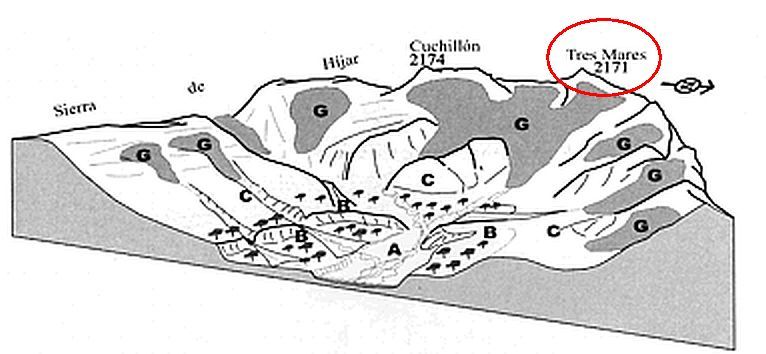
Los glaciares en su conjunto se caracterizaron por las lenguas cortas, encajadas en el sustrato y con fuertes pendientes que dieron lugar a un amplio cortejo de formas, circos encajados en relieves aplanados, con cubetas profundas. Todas ellas constituyen rellanos entre laderas escarpadas utilizados para pastos, seles y brañas, que encuentran en los circos y cubetas glaciares un espacio propicio para una explotación que continúa en la actualidad. En los frentes de las Sierras de Híjar, vertiente suroeste, y del Cordel, vertiente norte, le circos son más amplios y encajados, pues la acción glaciar no se ha impuesto con la misma eficacia, dado el desnivel la energía del relieve preglaciar.
La labor erosiva de los glaciares fue la más capaz para generar relieves en las cumbres de las montañas campurrianas. En los circos y valles glaciares depositaron morrenas (formas de acumulación generadas por el transporte y la sedimentación glacial en sus frentes y márgenes), que son un testigo de la extensión y evolución de los glaciares, y del clima. Existen complejos morrénicos (sucesiones de morrenas arquedas o rectilineas), de gran riqueza y variedad, como los de Guares, Brañavieja, con dos arcos seccionados por la carretera del collado de la Fuente del Chivo, que permite conocer su estructura interna.
Para logar este EarthCache, envíame un correo / mensage con las respuestas a las siguientes preguntas:
1) ¿Cual es el origen del hielo quue formo los glaciares? ¿Que altura alcanzaban los glaciares en la zona?
2) Dime dos marcas que los glaciares dejaron en dirección a Brañavieja ( La zona de la estación de ski )
3) ¿Que tipo de rocas hay en la zona (tipo y color)? ¿el mirador esta construido del mismo material?
4) Añade una fotografia tuya en el local, u otra en la que se pueda ver algún objeto, o tu nick en un papel
-Si crees que as concluido con exito los objetivos de este Earth Cache, y me ha enviado todas las respuestas solicitadas, puede hacer el log. Luego yo comprobaré que son correctas, y si hay cualquier problema me pondre en contacto para arreglarlo.
-Logs sin respuestas enviadas previamente, seran borrados sin aviso
English (GoogleTranslate)
Location
"Tres Mares (Three seas)" is a very accessible mythical summit as the highest road in Cantabria comes to the nearby viewpoint of the Goat. During the winter you can access the ski lifts in the ski resort of Alto Campoo mode or practicing backcountry skiing or snowshoeing. Picu Tresmares is a mountain located in the Montes de Campoo-Valderredible (called Circus Alto Campo), located between the autonomous community of Cantabria and the province of Palencia, Spain. Has an altitude of 2175 m, from the top of the mountain are observable four saws Alto Campo and Power Carrionas and a large part of the Picos de Europa.
It is the only mountain in the Iberian Peninsula pouring water to the three seas that surround the Iberian Peninsula. At Pico Tres Mares born three rivers, each running a different basin, reaching off into three different seas:
-Rio Nansa (north), which flow into the Bay of Biscay.
-a Tributary of the River Pisuerga (to the southwest), which in turn is a tributary of the Douro River, which flows into the Atlantic Ocean.
-The Río Híjar (to the southeast), whose karst upwelling Fontibre gives birth to the Ebro River, which flows into the Mediterranean Sea.
Geomorphology
The arch formed by the "Sierra del Cordel" and Híjar that converge, as is known, the most significant summit valley Tres Mares is a mountain environment characterized mainly by the contrast between the peaks and the background valley, and its attachment to the southern slope of the Cantabrian mountain.
The relief of Alto Campoo by morfoestructural evolution, ie folding, lifting and fracturing of the Mesozoic materials forming the covering in Campo, by their behavior against erosion and the recent modeling explained (exercised by rivers, glaciers and gravity acting on the slopes). Its current appearance is the result of a long evolution, which involved the formation of rocks and their arrangement in a series of more than 200 million years, and then in a shorter cycle, around one million first and a half years, erosion and minor forms settings (glaciers, river terraces, etc.)
Glaciarism
- How glaciers work?
Glaciers form when accumulated snow fall to the bottom and sides of valleys in high mountain areas. Thicknesses can reach large proportions if lost in the melting snow it is less than that accumulates during snowfall. Producie compact mass that compresses each snowfall snow falls earlier. If the heat does not manage to fuse the ice thickness is increasing and begins to move toward the valley. Snow density increases with depth. At the base of the glacier the highest density occurs due to the weight of the ice you have to endure. But this ice of the glacier base flows like liquid. The center of the glacier moves faster than the lateral masses, thereby breaks, tensions and stretches that are manifested in huge and deep cracks in the upper layers are produced.
The glacier is moving and tearing the protruding rocks in its path. These rock fragments are called moraines. In the end zone of the glacier where melting occurs, small hills which together form called terminal moraine. While the glacier snow continues to maintain power at the top, sliding down the valley it remains. Finally the glacier melts or dismembered forming streams.
-Glaciarism at Alto CAmpoo ( Tres Mares)
In the environment of the mountains Campurrianas has retained the imprint of 26 glaciers that generated forms of erosion, glacial cirques, troughs overburden today colmatadas and thresholds. The morphology is varied depending on the geological structure, the arrangement of the glacier and your organization in the past. Highlight the ways of further development on the northeast slope of the Sierra de Hijar, and fitted with little steep for the dip of the strata circuses. The accumulation of ice on Guzmerones, Hoyo Sacro, Pidruecos, Las Hoyas, donkeys or Tres Mares, united in one language, led glacier larger entity, Brañavieja glacier, 2,800 meters long and 150 meters thick, difluía in two languages, one to Hijar and another to Guares. In Valdecebollas, Circus Sel de la Fuente also shows breadth and complexity, staggered depending on the geological structure that supported a glacier 2 km long whose language difluía towards Híjar and towards the Pisuerga. The remaining glaciers were circus with small languages that only rarely exceeded a kilometer in length Cotamañinos or the northern slope of the Sierra del Cordel, where the orientation and the steep slopes of the vertical walls led to an abundant supply and the development of extensive glaciers that reached very low levels.
Glaciers as a whole are characterized by short languages embedded in the soil and steep slopes leading to a large procession of forms, circuses embedded in flattened relief, with deep troughs. All landings between steep slopes are used for grazing, and brañas Seles, who find in circuses and buckets glaciers an environment conducive to a holding space that continues today. On the fronts of the Sierras de Hijar, southwest side, and String, North Slope, we circuses are broader and deep, as glacial action has not been imposed as effectively, given the energy gap preglacial relief.
Erosive work of the glaciers was able to generate the reliefs on the tops of the mountains Campurrianas. In circuses and moraines deposited glacial valleys (forms of accumulation from transport and glacial sedimentation on their foreheads and margins), which are a witness to the extent and evolution of glaciers and climate. There are complex moraine (arquedas successions or moraines rectilinear), of great richness and variety, such as Guares, Brañavieja with two arches sectioned along the road of Col de la Fuente del Chivo, giving information on their internal structure.
To log this earthcache, send me an email / message with the answer to the following questions:
1) What it is the origin of ice forming glaciers? What height reached glaciers in the area?
2) Tell me two brands that glaciers left towards Brañavieja (The area of the ski resort)
3) What kind of rocks you are in the area (type and color)? It´s the viewpoint constructed with the same material?
4) Add a photo of yourself at the place, or another in which you can see an object, or your nick on a piece of paper
-If you believe you have successfully completed this Earth Cache goals and has alreadysent to me all the requirements as requested, Please, feel free to log it as found. Later i will verify the requirements sent and, if necessary, contact you in order to make the necessary corrections to your log.
-Logs without answers, will be deleted without notice.