Attention:
You have not to wait for our permission, but send the answer e-mail immediately together with the log! No logs like: "Will send the answers later, when back home, when having better internet", etc. Such kind of logs we will delete without prior notification.
In earth science, erosion is the action of exogenic processes (such as water flow or wind) which remove soil and rock from one location on the Earth's crust, then transport it to another location where it is deposited. Eroded sediment may be transported just a few millimeters, or for thousands of kilometers. Natural rates of erosion are controlled by the action of geomorphic drivers, such as rainfall; bedrock wear in rivers; coastal erosion by the sea and waves; glacial plucking; abrasion and scour; areal flooding; wind abrasion; and mass movement processes in steep landscapes like landslides and debris flows. (Wikipedia)
Big Sur Coast on Higway 1
A geologically distinct body of rock occupies a central part of the Big Sur coast, and gives that part of the coast a distinct geographic character. The geologic unit is the Charnockitic Tonalite, which is a very hard, massive, coarse-grained igneous rock with relatively few fractures. In contrast to the slopes to the north or south, which in many places alternate between steep slopes and benches, sea cliffs and terraces above the highway, this segment of the coast has almost uniformly steep slopes of 50% to 65% from sea level to elevations of 2000 feet or more. Although the slopes are very steep, they are apparently relatively stable; we mapped fewer landslides in this area than elsewhere. Overall, this segment has a moderate potential for landslides, largely related to small rock falls and debris slides, but there are zones of weakness in the tonalite, and major landslides have occurred in exceptional circumstances. The heavy rainfall in the winter of 1983 was one such circumstance.
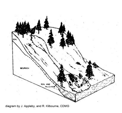
Types of landslides
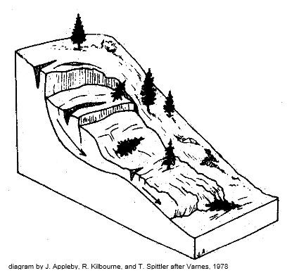
Each landslide is classified according to the materials involved and the movement type, as deduced from the associated landforms. A two-part designation is given to each slide, based on the system of Cruden and Varnes (1996). Materials are called either rock or soil, and soil is subdivided into fine-grained (earth) and coarse-grained (debris). This system was designed to allow a series of names that completely describes the materials and processes involved in a landslide.
Applying the system of Cruden and Varnes (1996), with the criteria described above, there are four predominant types of landslides.
ROCK SLIDE:
A slide involving bedrock in which much of the original structure is preserved. Strength of the rock is usually controlled by zones of weakness such as bedding planes or joints. Movement occurs primarily by sliding on a narrow zone of weakness as an intact block. Typically these landslides move down slope on one or several shear surfaces, called slide planes. The failure surface(s) may be curved or planar. In some older classification systems, slides with curved failure surfaces are commonly referred to as lumps, while those with planar failure surfaces are called block glides.
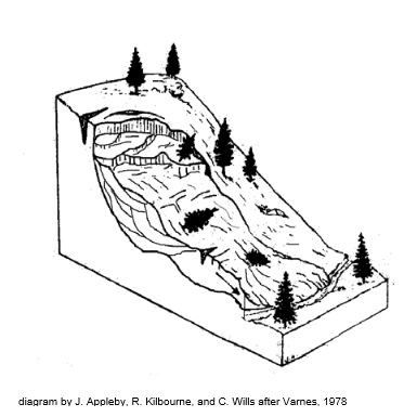
EARTH FLOW:
A landslide composed of mixture of fine grained soil, consisting of surficial deposits and deeply weathered, disrupted bedrock. The material strength is low through much of the slide mass, and movement occurs on many discontinuous shear surfaces throughout the landslide mass. Although the landslide may have a main slide plane at the base, many internal slide planes disrupt the landslide mass leading to movement that resembles the flow of a viscous liquid.
DEBRIS SLIDE:
A slide of coarse grained soil, commonly consisting of a loose combination of surficial deposits, rock fragments, and vegetation. Strength of the material is low, but there may be a very low strength zone at the base of the soil or within the weathered bedrock. Debris slides typically move initially as shallow intact slabs of soil and vegetation, but break up after a short distance into rock and soil falls and flows. 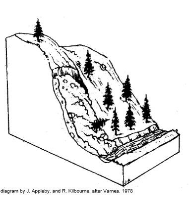
DEBRIS FLOW:
A landslide in which a mass of coarse-grained soil flows down a slope as a slurry. Material involved is commonly a loose combination of surficial deposits, rock fragments, and vegetation. High water pressures, typically following intense rain, cause the soil and weathered rock to rapidly lose strength and flow downslope.
Precipitation is a major factor influencing landslides. The Big Sur segment of Highway 1 receives up to 60 inches of rainfall annually. This amount of rainfall adds to the level of saturation of the landslide masses on the 23 coastal slopes, decreasing their stability. Long-term steady rain leads to deep saturation of landslide masses and tends to destabilize the larger, deeper types of landslides. Short-term, very intense rain tends to trigger the shallower types of landslides, such as debris slides and debris flows. 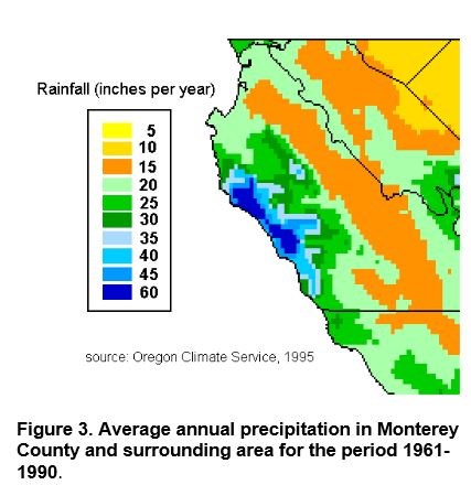
Logging requirements:
Send us a note with the answers to the following questions:
Look from the coordinates to the north. (As long as the trail to the coordinates of the EC it is is closed it's enough to go to the viewpoint-coordinates.) If you can't see enough you can skip question 1. Questions 2 to 5 are nevertheless possible to answer. Keep in mind, what happened here recently again (Hint: That was the reason for closing the trail to the overlook).
1. The rock material between the eroded material and the surrounding areas is significantly different. Describe the differences. (Grain, color, composition)
2. Which one of the described landslides do you believe happened here?
3. What has triggered the landslide? Note the last picture of the listing!
4. Where did the fall spill before 1983 compared to where they spill now?
5. What happens with the material that has flowed into the ocean?
6. Upload a picture with your log, please. Of course, that's optional but would be very nice.