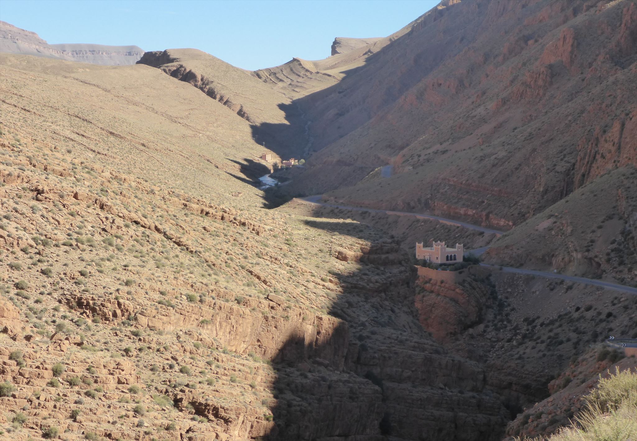
Das Dadestal (oder Dadesschlucht, auch frz. Gorges du Dadès; arabisch وادي دادس, DMG Wādī Dādis) liegt im nordafrikanischen Marokko im Atlasgebirge zwischen dem Hohen Atlas und der Djebel Sarhro-Gebirgskette.
Die Dades-Schlucht ist der Grand Canyon Marokkos. Seit etwa 25 Millionen Jahren hat der Fluss in der Südflanke des aufsteigenden Hohen Atlas dieses Tal gebildet. Es wird oft beschrieben, dass der Fluss älter als die Gebirgshebung ist - ein sogenannter Vorläuferstrom, der deshalb leicht seinen Kurs halten konnte. Hier bei Tarhía n 'Dades kann man sehen, dass es nicht ganz so leicht war: Der Fluss musste sich tief in die Gesteine einschneiden, die während des Aufstiegs des Hohen Atlas verformt und angehoben wurden.
Bevor Du diesen Earthcache loggst, lies bitte den folgenden Text und beantworte folgende Fragen:
Die Felsen, in die das Dadestal eingeschnitten ist, bestehen aus einer Abfolge von ehemaligen Meeresablagerungen. Einige sind harter Kalkstein, während andere mehr Ton enthalten und weicher sind.
1. Begib Dich an den nördlichen Eingang der Schlucht ( Ref Point 1: N 31° 33.420 W 005° 54.535 ) und schaue nach Osten. Dort kannst Du sanftere Hänge in weichem Gestein und Felsbänder aus Kalkstein erkennen. Jetzt schau nach Süden in die Schlucht. Erkläre mit Deinen Worten, warum sie hier ist?>/p>
2. Wie breit ist die Schlucht hier an der schmalsten Stelle?
Die Sedimentschichten der Schlucht waren ursprünglich horizontal und wurden aufgrund der Hebung der Berge gekippt.
3. In welche Richtung sind die Schichten geneigt? >/p>
4. In welchem Winkel sind sie etwa geneigt? (0 ° horizontal, 90 ° vertikal)

Serpentinen im Gorges du Dades
Dadès Gorges, (French: Gorges du Dadès), is a gorge of the Dadès River and lies between the Atlas Mountains and the Jbel Saghro of the Anti-Atlas mountain range, in Morocco.
The Dades Gorge is the Grand Canyon of Morocco. Since about 25 million years, the Dadès river has incised its valley into the southern flank of the rising High Atlas mountains. It is often described that the river is older than mountain uplift - a so-called antecedent stream – and could thus easily maintain its course. Here at Tarhía n' Dades you can see it was not that easy: The river had to cut deeply into bedrock deformed and raised during the uplift of the High Atlas.
Before logging this EarthCache, read the following text and answer the questions:
The rocks into which the Dades valley is cut were laid down as a succession of marine sediments. Some are hard limestone while others are more clay-rich and softer.
1. Standing at the northern entrance of the gorge (N 31° 33.420 W 005° 54.535), look east and spot gentler slopes in soft rock and rocky ledges made of limestone. Now turn right to the gorge. Can you explain why it is there?
2. How wide the canyon is here at its narrowest point?
The sedimentary layers exposed in the gorge were originally horizontal, but are now tilted due to uplift of the mountains.
3. In which direction are the layers inclined?
4. At approximately which angle are they inclined? (0° is horizontal, 90° is vertical)
Gorges du Dades
Les gorges du Dadès sont des gorges situées dans la haute vallée du Dadès entre les localités de Boumalne Dadès et M'semrir et une destination touristique fréquentée. L'oued Dadès et ses gorges sont situés entre le Haut Atlas et le djebel Saghro, à l'est-sud-est de Marrakech. Le Dadès est une rivière longue de près de 200 km, dont la moitié est située en zone montagneuse. Le long de son cours se succèdent 4 séries de gorges et défilés, profonds de 200 à 500 m.
Les gorges du Dadès est le Grand Canyon du Maroc. Depuis environ 25 millions d'années, la rivière a formé dans le flanc sud du Haut Atlas ascendant de cette vallée. Il est souvent décrit comme la rivière est plus ancienne que le soulèvement de montagne - un courant soi-disant précurseur qui pourrait donc facilement tenir son cours. Ici, à Tarhia n 'Dades peut voir que ce ne fut pas si facile, vous: La rivière a dû couper profondément dans les roches qui ont été déformées et levées lors de l'ascension du Haut Atlas.
S'il vous plaît Avant loggst ce cache, lire le texte ci-dessous et répondez aux questions suivantes:
Les roches dans lesquelles la vallée du Dadès est incisé, consistent en une série d'anciens sédiments marins. Certains sont calcaires durs, tandis que d'autres sons plus contenu et sont plus doux.
1. Embarquez sur l'entrée nord de la gorge (Ref Point 1: N 31 ° 33.420 W 005 ° 54 535) et de regarder vers l'est. Là, vous pouvez voir des pentes douces dans des bandes souples de rock et de rock de calcaire. Maintenant, regardez vers le sud dans la gorge. Expliquez dans vos propres mots, pourquoi est-il ici?
2. Quelle est la largeur du canyon est ici à son point le plus étroit?
Les couches de sédiments du canyon étaient à l'origine horizontale et ont été basculés en raison du soulèvement des montagnes.
3. Dans quelle direction les couches sont inclinées?
4. À quel angle ils sont environ inclinés? (0 ° à l'horizontale, 90 ° vertical)
Quelle/Source: Wikipedia