While traveling down I-55 you will not notice a hilly terrain thanks to MODOT for blasting away the “Upthrown” and smoothing out the “downthrown” sides of the Jackson fault line. This earthcache is located along the outer road that runs next to I-55. This outer road has enough space for you to pull off the road right next to the upthrown side of the fault line. Use caution while making your observations along the road here. If you get the chance travel southward past this spot along I-55 and look at the massive upthrown blocks of the Jackson fault line, they are truly amazing to see.
Physiographic provinces:

The Cape Girardeau – Jackson area encompasses parts of five distinct Physiographic divisions. The county as a whole lies within two separate Physiographic provinces. The southern portion, extending southward from the bluff line along Missouri 74 lies within the southeastern lowlands section of the Mississippi embayment province. The area north of the bluff line lies within the Salem plateau section of the Ozark plateaus province. The Salem Plateau extends eastward through Perry and Cape Girardeau counties into the shawneetown ridge or Shawnee hills, of southern Illinois. You are in the Salem plateau section of the Ozark plateaus province and in the division referred to as the “Perryville Sinkhole Plain” area. The rocks present in this fault line are of the Bailey formation and are cherty limestone. These rocks are more resistant to erosion than those in the surrounding areas.
Fault:
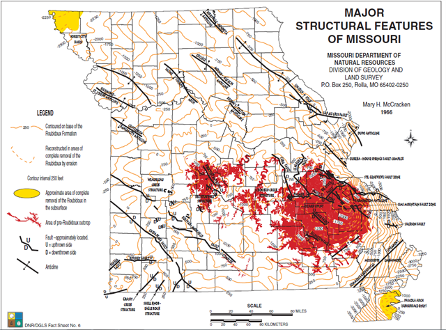
The Largest known fault in the county is the Jackson fault. This fault transverses the area from near the Missouri 34/72 junction, west of Jackson, to the Mississippi river near the northeastern corner of Cape Girardeau. Evidence indicates that the north side of this fault has been downthrown approximately 200 feet in relation to the south side. This fault is not known to be seismically active at the present time.
Different types of Faults
A close look at faults helps geologists to understand how the tectonic plates have moved relative to one another.

Normal faulting – where the crust is being pulled apart, normal faulting occurs, in which the overlying (hanging-wall) block moves down with respect to the lower (foot wall) block.
Reverse faulting – where the crust is being compressed, reverse faulting occurs, in which the hanging-wall block moves up and over the footwall block – reverse slip on a gently inclined plane is referred to as thrust faulting.
Dip-slip movement—Slip of one fault block, relative to the other block, by movement parallel to the dip of the fault. On any inclined surface, such as a fault in the Houston area, it is possible to draw an imaginary horizontal line, termed the strike of the fault, and to draw a second line perpendicular to the strike, termed the dip line. The angle by which the dip line deviates from horizontal is the dip of the fault; it corresponds to the inclination of the fault in nonscientific terms. If movement of one fault block relative to the other block occurs parallel to the dip line, it is termed dip-slip movement.
Downthrown side—The side of a fault that appears to have moved downward relative to the other side.
Upthrown side—The side of a fault that appears to have moved upward relative to the other side. (USGS)

Source: Photo
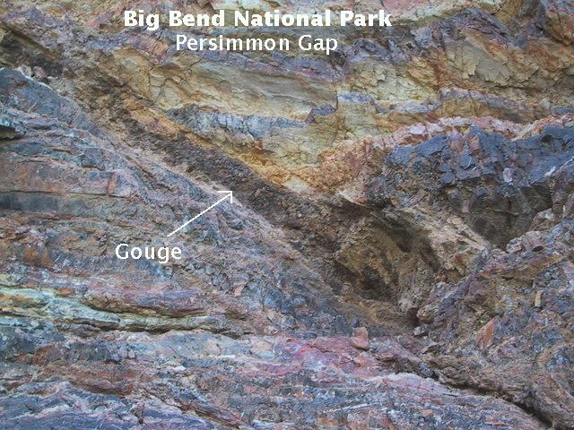
Nature’s crusher
Fault gouge is crushed and ground-up rock produced by friction between the two sides when a fault moves. (USGS)
Source: Web
**Logging requirements**
DO NOT POST ANSWERS IN YOUR LOG.
Send the following answers to me via email.
- The text "GC680C2 Jackson's Fault" on the first line
- Does this fault have any visible fault gouge and tell me what the color is?
- What are three primary colors of rocks here?
- What is the angle of this upthrown side? (There is an app for that, or if you must you can estimate)
- Elevation at GZ which is the upthrown side?
- Elevation at the downthrown side? (waypoint "Down")
| I have earned GSA's highest level: |
  |