Skip to content

Tucker and Cook Reservoir Traditional Cache

This cache has been archived.

Capt. Bob: I recently received this email
“Who gave you permission to place your geocache hide? It may be a government (town, state, or federal), business, or person. I'll need a name and contact info (phone or email) of the property owner to publish a geocache. Saying it's "public property" will not get your geocache published. This can be the trickiest question to answer - if it seems like public property you can call the town hall to ask, or try to find an assessor's map online (which lists owners) by doing a Google search for GIS town name map, and then contacting them. For municipal property, often someone in the recreation department can give permission.

Massquerade
Geocaching.com Volunteer Cache Reviewer”

None of my caches comply with this directive and I won't change them, therefore I will be archiving all of them. It’s been fun while it lasted!

More
Hidden : 1/16/2016
Difficulty:
2 out of 5
Terrain:
2 out of 5

Size: Size:   small (small)

Join now to view geocache location details. It's free!

Watch

How Geocaching Works

Please note Use of geocaching.com services is subject to the terms and conditions in our disclaimer.

Geocache Description:


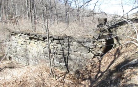
The South River was the key source of power during the heyday of manufacturing in Conway. This dam was constructed during the second half of the 19th century to form a reservoir. It was the biggest masonry structure in Franklin County at the time and was designed to supply the major mills with water especially during the dry months.

View from the cache.

In 1869, during an extreme weather event, the reservoir dam did breach, destroying 14 river bridges and damaging all of the mills along the river, and also pig pens, small buildings, houses, and factories. The reservoir breached for a second time on December 10, 1878.

Communal fears regarding the potential breach of this large reservoir prior to 1869 led to public backing of the "4-40 campaign" where the river channel was straightened and widened to a width of 40 feet for a distance of 4 miles from the reservoir to a point downstream of the village. Straightening of rivers was a common practice in New England during this period. However, this proved disastrous during extreme river flows. Without natural bends, river obstructions, flood plains, vegetation, etc. to slow the flow, river banks were eroded and the river changed course through the village. Recently, the effects were revealed again during Tropic Storm Irene.

Additional Hints (Decrypt)

Ovt I

Decryption Key

A|B|C|D|E|F|G|H|I|J|K|L|M
-------------------------
N|O|P|Q|R|S|T|U|V|W|X|Y|Z

(letter above equals below, and vice versa)