Lindsay's Station and Kentucky Spirit Quest (KSQ) #376
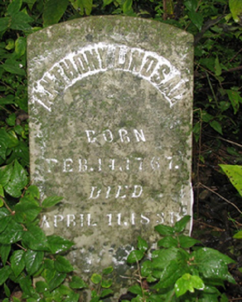
Lindsay's Station was established near where the Kentucky historical roadside marker stands today. Anthony Lindsay, a veteran of the French and Indian War and the American Revolution, was the proprietor of Lindsay's Station.
Around 1790, Anthony and Rachel Lindsay built Lindsay's Fort. It was situated on an old buffalo trace, leading north to the Ohio River and contained three cabins. It was a regular stop for travelers and traders and as a refuge for other families during Indian raids in the area. This fort was a typical two-family station of that day. Located high on a ridge overlooking a broad Buffalo Trace, a twelve-foot high stockade completely enclosed the area between two log block houses. About two hundred feet apart, the houses stood at opposite ends of the stockade, their only doors and windows were in the side of the wall which enclosed the two rows of logs that stood on end, making the stockade. The two identical blockhouses were two stories high. The top floor overhung the first floors by five feet. This made the fort easy to defend. There were no blind spots for the enemy to scale the stockade wall. There were also no windows on the outside walls; however, there were a great many slits used for loopholes. There was a large open fireplace to the east end of each blockhouse. This was used for both heating and cooking. There were other buildings built along both stockade walls. All these had sloping roofs. Most were used for cattle, horses, and other livestock. A few were pressed into service as housing in times of Indian troubles when neighbors took refuge with the Lindsays.
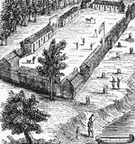
Plan of Daniel Boone's Station in Kentucky That May Have Been Similar to Lindsay's Station
Some of Lindsay’s descendants moved on from the area to Missouri. His great grandson was Jesse James, one of the most notorious outlaws in American history. The house where Jesse James parents were wed still stands in the Stamping Ground area. There is a geocache located near the location along the Historic Buffalo Geotrail.
Lindsay's grave is located in the Lindsay Cemetery, located just 100 yards north of the historical marker on private property. Please do not enter the property. There are several other marked graves located there.
The final is located at N38 16.ABC W084 41.DEF .
From the historical marker take the 3 digit number on the bottom right of the plaque.
To get ABC take the 3 digit number and add it to 230.
To get DEF take the 3 digit number and add it to 370.
Check sum is 37.
From GZ travel 1.17 miles at 143 degrees to get the final is another way.
This geocache is one of 10 geocaches along the Historic Buffalo Geotrail. Passports are to be given out at the June 4, 2016 Historic Buffalo Geotrail event. Geocachers will visit all 10 geocaches along the trail and stamp the corresponding block on the passport and turn it in for a prize as supplies last. Passports will be available outside at the designated Historic Buffalo Geotrail passport box on the front porch of Stamping Ground City Hall, 3374 Main Street, Stamping Ground, Kentucky. Completed passports can be turned in here as well.
Please remember to leave the designated stamp and ink pad inside of the geocache containers!