"Turf speelt een centrale rol in de economische ontwikkeling van de stad Groningen. Het werd niet alleen gebruikt voor de verwarming van woningen of werkplaatsen. De brandstof was ook onmisbaar in tal van productieprocessen, zoals het bakken van brood of de vervaardiging van bouwmaterialen. Vooral met deze laatste activiteit was een hoog turfverbruik gemoeid, bijvoorbeeld in de schelpkalk- en baksteennijverheid. De meeste tichelwerken bevonden zich oorspronkelijk ten noordoosten van de oude binnenstad. Dat had zowel te maken met de aanwezigheid van geschikte klei als met de aanvoermogelijkheden van turf uit het achterland en schelpen vanaf het Wad over de Hunze. Deze rivier liep oorspronkelijk met een ruime boog ten noordoosten van de stad. Het is niet toevallig dat we de Turfsingel aan de noordoostzijde van de oude binnenstad vinden. Daar werd de singel tussen het Schuitendiep en de stadsgracht als kalkwal gebruikt ten behoeve van de kalkbranderij en kalkopslag."
(Overgenomen uit Meindert Schroor, Historische atlas van de stad Groningen.).
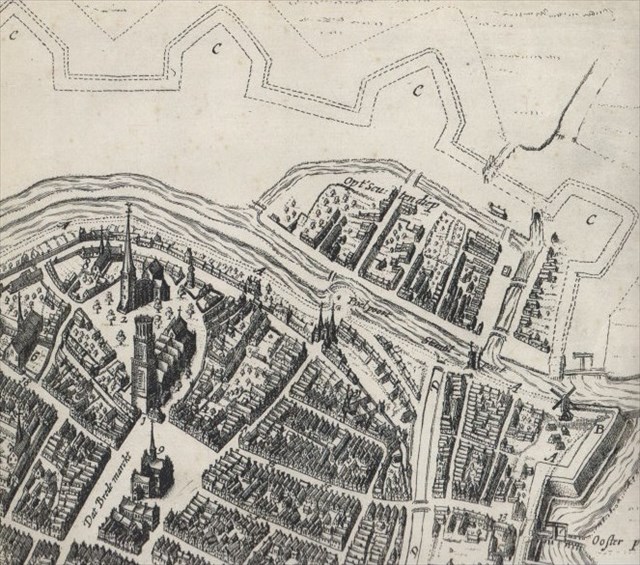
Tot het begin van de 17e eeuw lag binnen het Schuitendiep de daadwerkelijke stadsgracht, zodat er tussen beide wateren een singel liep, ongeveer waar nu de huidige Turfsingel loopt. Hieronder zie je een fragment van de vogelvluchtkaart van Nicolaas Geelkerchen uit 1616, waarop dit duidelijk zichtbaar is.
De opvallende uitstulping van de kade aan de Turfsingel ter hoogte van de Turfstraat is waarschijnlijk een overblijfsel van deze kalkwal. Tot 1941 zou dit stukje land als zodanig zijn gebruikt, als laatste door een stukadoor. Door de gemeente wordt de uitstulping 'Turfeiland' genoemd en het is benoemd tot 'Kroonjuweel'. Het is één van de weinige stukjes groen langs de de veelal versteende diepenring (de Groningse benaming voor de grachtengordel). Op dit bijzondere stukje land heb ik deze cache verstopt.
Vanaf hier kun je aan de Turfsingel enkele opvallende gebouwen zien. Als je over het water naar rechts kijkt zie je de de Stadsschouwburg, met daarnaast het Praedinius Gymnasium. Daar weer naast en recht tegenover het water zie je een woningbouwcomplex in de stijl van de Delftse school uit 1937, ontworpen door Siebe Jan Bouma.
Als je naar de andere kant (over de straat) kijkt zie je rechts, voorbij de Turfstraat, de muren van de Prinsentuin. De tuin is overdag vrij toegankelijk en is zeker een aanrader om eens te bekijken. Direct aan de overkant van de straat staat enkele oude woningen, die op het kadastraal minuutplan uit 1832 al te zien zijn. Kijk je naar links, dan zie je de nieuwbouw van het Provinciehuis.
Je kunt de cache verreweg het beste lopend of fietsend benaderen. Let bij het oversteken van de weg goed op, het kan hier behoorlijk druk zijn. Mocht je toch met de auto willen komen, dan kun je die tegen betaling langs de gracht parkeren. Ga absoluut niet met de auto stoppen ter hoogte van de cachelocatie! Kijk ter plekke uit voor hondenpoep.
Plaats de cache weer net zo terug als je hem gevonden hebt.
English:
"Peat plays an important role in the economic development in the city of Groningen. It wasn’t only used for the heating of homes and workplaces. The fuel was also essential in numerous production processes, like the baking of bread or the manufacturing of building materials. These building activities required high amounts of peat, like the shell lime and brick industry. Most of the brick factories were situated north east of the old inner city. The reason for this had to do with the presence of suitable clay as well with the supply abilities of peat from the hinterland and shells from the wadden sea. These supplies were landed from the Hunze river, which originally streamed north east of the city. It is no coincidence that we find the Turfsingel (Peat boulevard) on the north east side of the old inner city. The boulevard between the Schuitendiep and the city moat was used as a lime wall, for the purpose of lime burning and lime storage." (Taken from Meindert Schroor, Historische atlas van de stad Groningen.).
The remarkable bulge in the quay of the Turfsingel at the height of the Turfstraat probably is a remnant of this lime wall. Up to 1941 this piece of land was used as such, lastly by a plasterer. The Groningen township calls this piece of land 'Turfeiland' (Peat Island) and has declared it a 'Kroonjuweel’ (Crown Jewel). It is one of the few bits of green alongside the mostly turned to stone canals. On this beautiful place I hid this geocache.
From here you can see a few remarkable buildings. When you look over the water to your right, you see the Stadsschouwburg (City Theater). Next to the theater is the Praedinius Gymnasium. Straight across the water you see a residential building in the style of the Delftse school, designed by Siebe Jan Bouma. When you look to the other side (over the street) to your right, past the Turfstraat, you see the walls of the Prinsentuin (Garden of the Prince). The garden is open to the public during the day. If you have the time, I recommend you to go and see it. Directly on the overside of the street you see a few old buildings from the 19th or 18th century. When you look to your left, you see the new building of the provincial government.
The cache can best be approached by bike or by foot. The traffic can be very busy here, look out when you cross the street. If you want to come by car, you can park against a fee alongside the canal. Absolutely don’t stop your car alongside the cache location! This is very dangerous. Look out for dog poo at the cache location.