Ferguson Spring EarthCache
Please note Use of geocaching.com services is subject to the terms and conditions
in our disclaimer.
Welcome to Ferguson Spring. You will be using your skills of observation to classify the spring, measure the spring run, and determine the age of the rock strata surrounding the spring is located at the given coordinates. Bring a soda/water bottle, a ruler of some length, something type of calculator and a camera of some sort.
Logging Requirements: In order to claim a find on the Earthcache you must do three things:
A. Email or Message me you answers to the following questions:
1. Is Ferguson Spring an ARTESIAN or a GRAVITY spring?
2. Does the Spring Outlet classify Ferguson Spring as a SEEPAGE, a FRACTURE, or a TUBULAR spring?
3. Using the most handy of all measuring devices - a standard soda/water bottle and a timer, determine the SPRING MAGNITUDE.
4. Measure the length of the SPRING RUN from the pool to the edge of Crooked Creek. This WILL vary throughout the year.
5. Study the rock strata surrounding the spring opening (not the pipe under the road) and determine which of the five STRATA exists.
B. Sign the on-line log. Include with your log:
1. A description of how you measured the magnitude and the spring run. NOT YOUR MEASUREMETNS OR CACLCUALTIONS.
2. Optional, but greatly appreciated: A picture of you (and your crew) at Ferguson Spring.
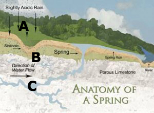
Anatomy of Springs
Factors Affecting Spring Flow
The amount of water that flows from springs depends on many factors, including the size of the crevices or caverns within the rocks, the water pressure in the aquifer, the size of the spring basin, and the amount of rainfall. If the groundwater is under sufficient pressure, the spring (or a well) might shoot water into the air-artesian well or spring.
Human activities also can influence the volume of water that discharges from a spring—groundwater withdrawals in an area can reduce the amount of water and the pressure in an aquifer, causing water levels in the aquifer system to drop and ultimately decreasing the flow from the spring.
Types of Springs
Springs are classified in several ways.
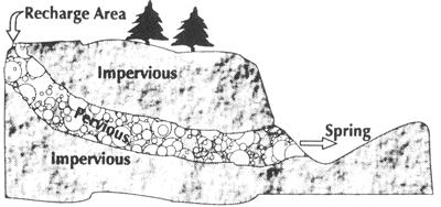
A. Artesian and Gravity
An ARTESIAN spring occurs when the groundwater, under pressure, finds its way to the land surface. An artesian spring flows because the pressure in the aquifer is greater than atmospheric pressure at the land. These types of springs usually occur along faults (a fracture in the earth), or in areas of great topographic relief such as cliffs or valleys.

Artesian Spring Gravity Spring
A GRAVITY spring is formed by water soaking into the ground until the water encounters a confining layer that will not let the water seep further down. The water then flows across the top of the confining layer until it reaches the ground surface. Examples of gravity springs are springs found in hillsides or cliffs.
B. Types of Spring Outlet:
SEEPAGE OR FILTRATION SPRING: The term seep refers to springs with small flow rates in which the source water has filtered into the permeable earth.
FRACTURE SPRINGS: Discharge from faults , joints , or fissures in the earth, in which springs have followed a natural course of voids or weaknesses in the bedrock.
TUBULAR SPRINGS: essentially water dissolved and created underground channels, basically cave systems.
C. Spring Discharge
Springs are also classified by the volume of the water they discharge. The scale for spring flow is as follows:
Magnitude
|
Flow
(ft³/s, gal/min, pint/min)
|
Time to Fill
ONE Typical Soda/Water Bottle
|
1st
|
> 100 ft³/s |
> 600 bottles in 1 second
|
2nd
|
10 to 100 ft3/second
|
60 to 600 bottles in 1 second
|
3rd
|
1 to 10 ft3/second |
15 to 60 botles in 1 second
|
4th
|
100 U.S. gal/min to 1 ft3/second
(448 U.S. gal/min)
|
200 to 900 bottles in 15 seconds
|
5th
|
10 to 100 U.S. gal/min
|
4 to 40 bottles in 3 seconds
|
6th
|
1 to 10 U.S. gal/min
|
1 to 20 bottles in 15 second
|
7th
|
1 pint to 1 U.S. gal/min
|
1 to 4 bottles in 30 seconds
|
8th
|
less than 1 pint/min
|
1 bottle in 1 or more mintes
|
0
|
no flow
(site of past/historic flow)
|
no flow |
GEOLOGY OF FERGUSON SPRING AREA
Land Between The Lakes (LBL) is an inland peninsula formed when the Cumberland and Tennessee Rivers were impounded to create Kentucky Lake and Lake Barkley, an inland peninsula was formed. Ferguson Spring lies at the back end of Energy Lake on Crooked Creek of Lake Barkley/Cumberland River.
The area, at the western-most part of the Mississippian (or Pennyroyal) Plateau of south-central and western Kentucky, is an upland region underlain by Mississippian rocks, mostly limestones. This part of the Mississippian Plateau forms highlands capped by basal Cretaceous and Tertiary gravels above the Cumberland and Tennessee River valleys.
Five principal strata can be found near and around Ferguson Springs. These include:
STRATA
|
CHARACTERISTICS
|
AGE
|
| Alluvial (Qal) |
Clay, silt and gravel
Pale-brown, yellowish-brown, reddish-brown, light-brown
Poorly to well-sorted
contains organic matter
|
Quaternary
2.6 to 11.7 MYA
|
Gravel (Qtg)
|
Light-brown, well sorted
Chert pebbles deeply iron-stained
|
Tertiary
2.6 to 65 MYA
|
| Tuscaloosa Formation (Kt) |
Gravel, poorly sorted and unconsolidated
very-light gray to light-gray
|
Upper Cretaceous
66 to 145 MYA
|
| Warsaw Limestone (Mw) |
Limestone, light ot medium gray
Crinoid and Bryozoan fossil fragments abundant
Gray chert nodules
|
Mississipian - Meramec
330-346 MYA
|
| Fort Payne Formation (Mfp) |
Limestone, medium to dark gray
Crinoid and Bryozoan fossil fragments rare
Some iron-banding
|
Mississipian - Osage
347-359 MYA
|
Additional Hints
(No hints available.)
Treasures
You'll collect a digital Treasure from one of these collections when you find and log this geocache:

Loading Treasures