About one tenth of the world's surface is covered in ice, but 20,000 years ago when the climate was colder, this would have been more like one third. In those times much of Britain, including Cumbria, would have glaciers and year-round snow fields covering the landscape. Glaciers 100's of metres deep would have slowly ground their way down the valleys around Grasmere. In that time, and in previous Ice Ages, the shapes of the Lake District dales, fells and lakes were created. It was not until about 11,000 years ago that the last Lakeland glacier melted.

As the ice moved down Easedale it scoured the valley floor. However, some parts of the bedrock were just too strong to give way. The ice and rock of the glacier scraped these parts smooth on the 'upstream' side. The 'downstream' sides were more protected and were left with a rougher, more broken surface.

These outcrops of glacier-worn bedrock are called roches moutonnes ('sheep-rocks' in French).
The stream that flows through Easedale is called Far Easdale Gill which has a tributary further down the valley, Sour Milk Ghyll. Although it is only a small stream it has created an impressive series of waterfalls and plunge pools. A lot of the work done to create the waterfalls was done by the ice of the glacier and the water melting from it. Towards the end of an ice age, huge amounts amounts of meltwater would flow out of the glacier during the summer months.
There are almost two tarns in Easdale. Huge forces caused by millions of tonnes of ice have scooped out the main Easedale Tarn. Lower down the valley are several 'bowls' which are filled with bog today. The white flowers are Cotton Grass (not a grass at all, but a member of the sedge family).

From around the edges of Easdale Tarn lots of rock would have been carried away by the glacier. This boulder near the outflow (where the stream leaves the tarn) is a fine example. Boulders like this can be carried for hundereds of miles by ice and then left stranded far from their home. When this happens they are known as erratics. There are similar boulders of volcanic rock perched on the limestone around Witherslack.
Morraine is a mixture of fine ground rock, gravel, boulders and all sizes of rock inbetween. Morraine is collected by a glacier as it scrapes its way downhill and it is left behind when the glacier melts. The 'lumpy' appearance of the land across the tarn is due to the piles of morraine left behind when the Easedale glacier melted. This landscape is very common around corries. It is called hummocky morraine.
Most tarns are dammed in by piles of morraine and this is the case at Easedale. Where a stream leaves a tarn it cuts through the morraine at an outflow. At the back of tarns there is usually a shattered wall of rock, a headwall. These have been made by the plucking action of ice as it forces its way down the rock.
Waterfalls are commonly formed in the upper course of the river. At these times the channel is often narrow and deep. When the river courses over resistant bedrock, erosion happens slowly, while downstream the erosion occurs more rapidly. As the watercourse increases its velocity at the edge of the waterfall, it plucks material from the riverbed. Whirlpools created in the turbulence as well as sand and stones carried by the watercourse increase the erosion capacity. This causes the waterfall to carve deeper into the bed and to recede upstream. Often over time, the waterfall will recede back to form a canyon or gorge downstream as it recedes upstream, and it will carve deeper into the ridge above it. The rate of retreat for a waterfall can be as high as one and half meters per year.

Often, the rock stratum just below the more resistant shelf will be of a softer type, meaning that undercutting due to splashback will occur here to form a shallow cave-like formation known as a rock shelter under and behind the waterfall. Eventually, the outcropping, more resistant cap rock will collapse under pressure to add blocks of rock to the base of the waterfall. These blocks of rock are then broken down into smaller boulders by attrition as they collide with each other, and they also erode the base of the waterfall by abrasion, creating a deep plunge pool or gorge.
Streams become wider and shallower just above waterfalls due to flowing over the rock shelf, and there is usually a deep area just below the waterfall because of the kinetic energy of the water hitting the bottom. Waterfalls normally form in a rocky area due to erosion. After a long period of being fully formed, the water falling off the ledge will retreat, causing a horizontal pit parallel to the waterfall wall. Eventually, as the pit grows deeper, the waterfall collapses to be replaced by a steeply sloping stretch of river bed. In addition to gradual processes such as erosion, earth movement caused by earthquakes or landslides or volcanoes can cause a differential in land heights which interfere with the natural course of a water flow, and result in waterfalls.
As the streams flow downhill, they carve out the softer rock to form gorges.
The simple answer to how a gorge is formed is by water erosion, but in actual practice, a number of factors come together to make a gorge possible.
Flooding
One potential source of gorge formation is major, systematic flooding. Geologists believe that during the last ice age, rapid melting of the great glaciers caused catastrophic flooding that carved out several gorges and canyons along already existing waterways. The same pattern can be seen today, albeit in a much less violent form. Spring thawing regularly causes river flooding in areas where rivers are fed primarily by glaciers. The gorges formed when the erosive power of the flooding was slowed down upon harder strata of rock, causing cliffs to form and the flooding to dig down, rather than out.
Waterfalls
Another source of gorge formation is a waterfall. Waterfalls themselves are usually the product of geologic uplift. When there is geologic uplift in an area that is already home to a watercourse, the resulting change in elevation creates a waterfall. That waterfall creates accelerated water flow and erosion, which over time will cut back on itself, creating a gorge. Even if the watercourse lacks the power to carve the hard rock in its own bed away, if softer rock has been exposed below by geologic uplift that will be eroded and washed away. This undermines the original river bed, causing eventual and successive collapse, forming a gorge.
In order to log this Earthcache, answer the following questions:
- How do you think this waterfall was formed?
- How high is the waterfall?
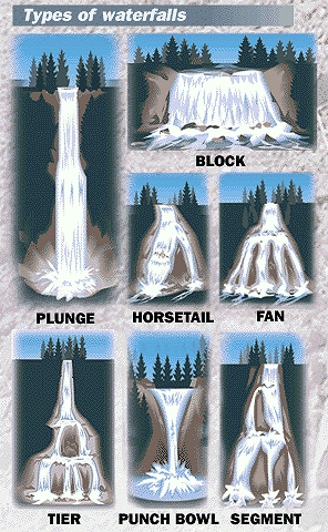
- Based on the image above, what type of waterfall do you think it is? Explain how you reached your conclusion
- Estimate the depth of the plunge pool
- How many litres of water do you think pass over the waterfall each second?
- How deep is the Gorge that the stream runs down?
- How many different types of valley are there at this location?
- How were the different valley types formed and how are they different?
- As an optional extra, post a photo of yourself or your GPS in front of the waterfall and tell us about your adventure getting here!