West Kingsdown is a village and civil parish in the Sevenoaks district of Kent, England. It is located on the A20, around 5 miles (8 km) southeast of Swanley and around 5.5 miles (9 km) northeast of the town of Sevenoaks.
The parish was part of Axstane Hundred and later Dartford Rural District. The village, because of its situation near London, grew considerably after the First World War from a relatively small farming community to a commuter village of around 5000 residents, expanding mainly on the northeast side of the A20. To the southwest of the main village are the rural housing developments of Knatts Valley and East Hill. To the north of the village lies the Brands Hatch motor racing circuit. There are four churches in the village: the parish church of St Edmund King and Martyr; West Kingsdown Baptist Church; the Roman Catholic church of St Bernadette; and Kings Church, an Evangelical church established in 1996.
Kingsdown, the former name of West Kingsdown village, traces its origins back to Anglo-Saxon settlements in the woods above the Darenth Valley. Farmers carved out pockets of land for arable farming. The Saxons also provided the name - 'the King's own hill pasture'. There is evidence that the parish church, St Edmund King and Martyr, was originally of Saxon construction. It appears that Edward the Confessor owned Kingsdown and the property passed into the ownership of William I following the Norman Conquest in 1066.
From 1066 to 1630 the ownership of the land in and around Kingsdown passed into the possession of a series of landlords, including Edward IV. From 1630 until 1784 there were absentee landlords. Records from 1664 show there were around 30 houses in the parish, so the population may have been around 150 people, a third of whom were too poor to pay tax. A census in 1676 recorded 90 people aged over 16. No-one was, or admitted to being - a Roman Catholic or a nonconformist. In this period roads through the village grew in importance and a turnpike was set up on what is now the A20 to provide income. Around 1780 the route was realigned, making it easier to travel through the village.
At the first national census in 1801 the population was recorded as 337. By 1901 the population had only risen to 506, falling to 407 in 1911 and 427 in 1927. In 1894 a National School was built on what is now School Lane. Post the First World War the relatively stable farming community became a scattering of holiday homes, garages, shacks and smallholdings as commuters settled outside London and found homes in the countryside. In 1918 there were two shopkeepers in the village. By 1938 there were six garages, nine shops and ten cafes.
Between 1921 and 1981 the number of Kingsdown residents grew substantially to nearly 5000. Cul-de-sac construction added to the existing roads and several park home estates were built for older residents. A new primary school on Fawkham Road was built to take the growing number of children. Electricity was introduced in 1937 but mains drainage was only installed in 1968. During this period Brands Hatch Farm opened its land to cyclists for racing, the precursor to Brand Hatch Racing Circuit. The A20 was widened to a dual carriageway (subsequently reduced to single carriageway) and the trees that lined the road lost to the village. The construction of the M20, taking traffic to Dover, meant that the village was no longer a major thoroughfare for cars, coaches and lorries.
In the 1950s Kingsdown changed its name at the request of the Post Office to avoid confusion with other villages in east Kent with the same name and became West Kingsdown.
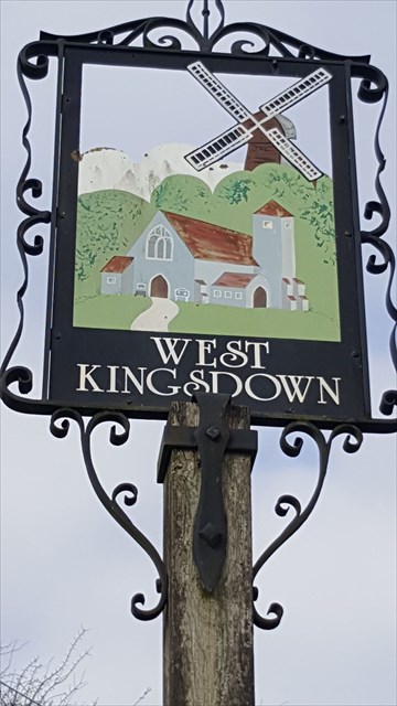
West Kingsdown Windmill as depicted in this Village Sign is a Grade II listed smock mill that was built in the early nineteenth century at Farningham. The windmill was marked on Greenwoods map of 1821 and the Farningham Tithe Map of 1840. In 1880, it was moved to Kingsdown, where there was already a post mill. The post mill burnt down in May 1909. The windmill is located on the east side of the village, off Pells Lane.
Brands Hatch motor racing circuit is located off the A20 on the north side of West Kingsdown. The circuit was used in 1926 as a grass track for bike riding and the first race held there in 1928 - a race between competitors riding bicycles and cross-country runners. The track hosted Formula 1 racing between 1964 and 1986 and runs major motor sport events during the year. In 2012 Brands Hatch was the venue for the Paralympic Games road cycling.
The coordinates given are for the location of this village sign. In order to locate the cache please mull over the following puzzle:

N51 20. E-C D/F J+G
E000 15. A+B+C F+J B-H

If anybody would like to expand this series please do. I would just ask that you let Smokeypugs know first so they can keep track of the Village Sign numbers and names to avoid duplication.