Background
As anyone who has traveled to the British Virgin Islands and visited Anegada knows, Anegada is a very different type of island from the rest. While the other BV islands - Tortola, Jost Van Dyke, Virgin Gorda - are mountainous in nature, a legacy from their volcanic past, Anegada is very flat, reaching only 38 feet at its highest point and leading it to be known as the ‘Drowned Land’. A look in the guidebooks will tell you the reason for this; Anegada was not formed as the result of volcanic activity, rather it was formed from a coral reef.
A more specific description would be an ‘emergent Pleistocene reef’. (S Gore, 2013) Anegada is a young island compared to the other BVIs. It only began forming as a reef between 119,000 and 130,000 years ago (Pleistocene epoch), while the formation of the other BVIs began 80 million years ago (Late Cretaceous epoch). Anegada began as a submerged reef comprised of living corals, but then around 100,000 years ago sea levels dropped due to ice age glaciation and the entire platform which contains Anegada, the other BVIs and Puerto Rico emerged above sea level (you could actually walk from Anegada to Puerto Rico!). During this time of exposure to the sun and wind the reef died and started transforming into Limestone; this transformed reef is now referred to as the Anegada Limestone Formation. Around 20,000 years ago, when the climate warmed and sea levels rose once again, the reefs began building up in an attempt to keep up with the rising water levels. (IRF, 2013) A result of this reef building was the formation of a new fringing reef along the north side of Anegada. The fringing reef is between approximately 5 meters to 3 kilometers offshore and a lagoon area exists between the shoreline and the reef (see image below) (Gore, 2013). Guidebooks will tell you that this lagoon is an excellent area for snorkeling and diving!
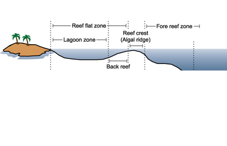
Image credit: NOAA URL: http://oceanservice.noaa.gov/education/tutorial_corals/coral04_reefs.html
Loblolly Bay
The northeastern section of Anegada where Loblolly Bay is located is composed mainly of the Anegada Limestone Formation and consists of a relatively straight shoreline, a fringing reef and a lagoon area between the two. The straightness of the shoreline may be due to the fact that the shoreline is comprised of a lot of Pleistocene bedrock and beachrock, both of which resist coastal erosion. (Erosion is a process which moves rock, soil and sand from one place to another and can be caused by many things, including wind, rivers, glaciers or, in this case, by coastal processes, such as tides, waves and ocean currents.) Still, there has been some erosion in a few areas due to the fact that narrow channels exists in the protective fringing reef which allow currents and waves to pass through, and the entire coastline experiences easterly winds and waves. (Gore, 2013)
The result of this coastal erosion along the Northeastern coast has been the formation of crenulated bays, or scallop shaped indentations in the shoreline where gaps in the reef exist. Loblolly Bay is an example of one of these crenulated bays. Loblolly Bay is shown in the photo, and is located between two headlands (land surrounded on 3 sides by water) – Jack Bay Point to the northwest and Loblolly High Point to the southeast.
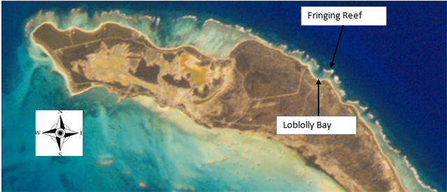
Image of Anegada. Credit: Earth Science and Remote Sensing Unit, NASA Johnson Space Center (http://eol.jsc.nasa.gov/SearchPhotos/photo.pl?mission=ISS004&roll=E&frame=8148)
Starting at the posted coordinates, turn so that the sign is to your right, and then following the trail ahead through the sea grape bushes, walk down to the shoreline. As you approach the water, you will see the crenulated shape of the beach. The nearby headland on your left is Jack Bay Point and the further away headland on your right is Loblolly High Point. Look out to the water and see if you can discern where the lagoon ends and the fringing reef begins. Can you see any channel in the reef that has allowed erosive forces to impact the shoreline?
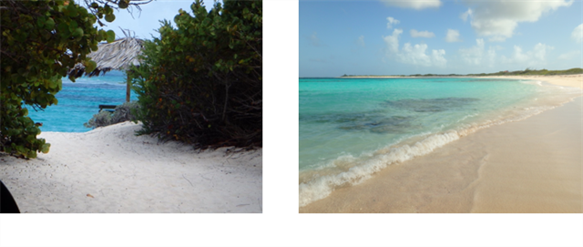
Images: (Left) View of Lobolly Bay through the Seagrapes and (Right) View of Loblolly Bay with Loblolly High Point in the background
Enjoy the fantastic view and then answer the questions below.
Logging Requirements
To log this cache, send me a message with the answers to the following questions. Please do not post any ‘spoiler’ photos in your log and do not include the answers in your log:
-
How long ago did Anegada begin to form as a reef?
-
Explain when and why the reef died and turned to limestone.
-
How has the crenulated bay formed at Loblolly?
-
Describe what you see where the lagoon meets the fringing reef.
-
Looking at the sign at the posted coordinates, list the 3 erosive forces that can exist between November and March.
-
Based on your observations, do you believe that Loblolly Bay will become more crenulated, that is develop a deeper scallop shape? Why or why not?
Optional ‘brownie’ point – post a picture of yourself and/or your GPS/smartphone on the beach with one of the headlands, Jack Bay Point or Loblolly High Point, in the back ground.
Sources:
Coral Reefs of the United Kingdom Overseas Territories, Chapter 5 S. Gore, 2013
Island Resources Foundation. 2013. An Environmental Profile of the Island of Anegada, British Virgin Islands. Island Resources Foundation. Tortola, British Virgin Islands and Washington, DC. 289: Chapter 1.1 The Physical and Natural Setting pp 1-8 http://j.mp/BVI_Anegada