Geopark Moryń EarthCache
-
Difficulty:
-

-
Terrain:
-

Size:  (other)
Please note Use of geocaching.com services is subject to the terms and conditions
in our disclaimer.
Many thanks to Mosznir for polish translation!

Polski
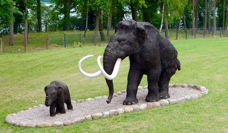
Znajdujesz się w Kamiennym Ogrodzie, będącym częścią Moryńskiego Geoparku. Jest to partnerski projekt stworzony w ramach współpracy polsko-niemieckiej. Przy kamieniach znajduje się cudowna ścieżka biegnąca wzdłuż brzegu rzeki, gdzie możesz obejrzeć i dotknąć prehistoryczne zwierzęta.
Od 15 do 20 tys. lat temu, podczas epoki lodowcowej, lód z lodowca przeniósł wiele głazów w pobliże Morynia. Pochodzą one z różnych regionów Skandynawii i rejonu Morza Bałtyckiego. Jako świadectwo plejstoceńskich ruchów lodowcowych część głazów posiada rysy lodowcowe. Te zagłębienia w materiale skalnym są rezultatem wzajemnego oddziaływania lodowców i skał niesionych przez masę lodowcową. W Skalnym Ogrodzie gdzie się teraz znajdujesz, zgromadzone jest 35 głazów. Są one świadkami bogatej historii geologicznej. Wśród zgromadzonych okazów znajduje się: 11 magmowych, 16 metamorficznych i 8 osadowych skał.
Wyróżniamy 3 rodzaje skał ze względu na ich genezę:
1. Skały magmowe
Skały magmowe powstają, przez zastygnięcie magmy w głębi skorupy ziemskiej lub lawy już na powierzchni ziemi. Ze względu na głębokość krzepnięcia wyróżnia się skały plutoniczne (głębinowe, gdzie proces zastygania odbywa się na głębokości 5-30 km), wylewne- krzepnące na powierzchni oraz żyłowe przyjmujące formę żył magmowych- intruzji.
2. Skały metamorficzne
Skały metamorficzne tworzą się ze skał magmowych, osadowych, a także przeobrażają się z innych skał metamorficznych pod wpływem wysokiej temperatury oraz wysokiego ciśnienia. Proces ten powoduje zmianę składu mineralnego skały i/lub zmianę jej tekstury. Powodem przeobrażania się skał jest dążenie minerałów skały macierzystej do stanu fizyczno-chemicznej równowagi oraz dopasowanie do warunków panujących w otoczeniu. Pierwotny materiał skałotwórczy poddany zmieniającemu się ciśnieniu i temperaturze jest niestabilny, w wyniku czego następuje przemiana minerałów lub powstaje nowa struktura skalna na tyle silna, by sprostać nowym warunkom otoczenia.
3. Skały osadowe
Skały osadowe powstają w wyniku nagromadzenia, a następnie osadzenia produktów wietrzenia starszych skał, a także elementów roślinnych i zwierzęcych w różnym stopniu rozkładu, jak również mogą się wytrącać z roztworów wodnych. Zwietrzałe skały mogą być pochodzenia magmowego, metamorficznego lub powstawać w środowisku sedymetacyjnym. Skały osadowe powstają przy powierzchni mórz, w okolicach płytkich wód, przy brzegach i ujściach rzek, w zależności od tego gdzie nagromadziły się elementy skalne lub organiczne transportowane przez wiatr, wodę (w postaci roztworu lub zawiesiny) lub lód.
W tym skalnym ogrodzie możesz także zobaczyć głazy nazywane graniakami (wentyfakty, wiatrowce), które wyróżniają się swoją specyficzną formą:
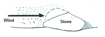
Graniaki należą podobnie jak głazy narzutowe i moreny do dziedzictwa epoki lodowcowej w naszym kraju. Nazywane też wentyfaktami, lub wiatrowcami. Jak sugeruje nazwa, to wiatry kształtują te formy skalne. Występują one prawie wyłącznie w strefie peryglacjalnej (na przedpolu lądolodu) oraz na pustyniach żwirowych i kamienistych. Na terenie Polski oraz północnych Niemiec znajdują się tereny morynowe, zimne pustynie oraz zimne stepy, które były bardzo powszechne czasie lodowaceń (zlodowacenie środkowopolskie oraz ostatnie zlodowacenie). U podnóża topniejącego lodowca, wiatr wstecznie wydmuchiwał jego elementy, które następnie chłodzone na lodzie tworzyły zimne podmuchy wiatru. Odsłonięte wówczas skały na terenach piaszczystych i ubogich w roślinność poddawane były niszczejącemu działaniu wiatru, który przenosząc ziarenka piasku doprowadzał do mechanicznego ścierania powierzchni skał.

Piasek działa na skały jak materiał ścierny. Kierunek wiatru dominujący od strony czołowej (nawietrznej) powoduje szlifowanie i polerowanie skały, natomiast gdy kierunek wiatru jest od strony tylnej (zawietrznej) skała pozostaje niezmieniona. Prowadzi to do powstawania na powierzchni skały mniej lub bardziej ostrych krawędzi. Więcej niż jedna krawędź powstaje w sytuacji, gdy skała znajduje się w trakcie procesów rzeźbotwórczych i zmienia on wielokrotnie swoją pozycję lub gdy wiatr zmienia swój kierunek.
Proszę odpowiedz na parę pytań:
1. Wymień i opisz wygląd głazów nr 12, 15 oraz 21! Do jakich grup (klas) skalnych one należą!
2. Który z trzech wymienionych głazów posiada na swojej powierzchni rysy lodowcowe?
3. Wymień co najmniej dwa rodzaje głazów o charakterze graniaka (wiatrowca)!
4. Wymień co najmniej trzy prehistorycze gatunki zwierząt które można było spotkać nad brzegiem rzeki!
5. Opcjonalnie: dołącz Twoje/Wasze zdjęcie lub zdjęcie GPSa w trakcie logowania w Geoparku!
Udzielenie poprawnych odpowiedzi jest warunkiem zalogowania znalezienia! Wyślij do nas e-mail z Twoimi odpowiedziami. Po wysłaniu e-maila z odpowiedziami możesz zalogować znalezienie. Gdy jakaś odpowiedź będzie niepoprawna- skontaktujemy się z Tobą. Nie musisz czekać na nasze pozwolenie na zalogowanie znalezienia! Mamy wielką nadzieję, że spodoba Ci się geologiczna wyprawa!

Deutsch
Ihr befindet euch hier im Steingarten von Moryń, einem Teil des Geoparks Moryń. Dies ist ein Partnerprojekt des Geoparks Eiszeitland am Oderrand in Deutschland. Ganz in der Nähe befindet sich auch ein wunderbarer Uferweg mit urzeitlichen Tieren zum Anschauen und Anfassen.
Vor 15 bis 20 Tausend Jahren, während der letzten Eiszeit, haben die Eismassen der Gletscher viele Findlinge in die Gegend von Moryń mitgebracht. Sie stammen aus verschiedenen Regionen Skandinaviens und aus dem Ostseeraum. Als Zeugnis eiszeitlicher Gletscherbewegungen haben einige der Steine sogenannte Gletscherschrammen. Darunter werden eingekritzte Furchen auf der Oberfläche von Gesteinen oder Felsen verstanden. Sie sind das Ergebnis vom Zusammenspiel von im und an Gletschern mitgeführten Gesteinen und der Auflast des Eises.
In diesem Steingarten wurden 35 Findlinge gesammelt. Sie sind Zeugen vom Reichtum der geologischen Geschichte. Unter den ausgestellten Findlingen gibt es 11 magmatische Gesteine, 16 metamorphe Gesteine sowie 8 Sedimentgesteine.

Nach ihrer Entstehung unterscheidet man 3 Gesteinsklassen:
Magmatische Gesteine
Magmatite, bzw. magmatische Gesteine, sind durch Abkühlung aus einem Magma das vom Ort seiner Bildung im Erdmantel oder in der tiefen Erdkruste aufsteigt, entstandene Gesteine. Nach der Tiefe ihrer Erstarrung unterscheidet man zwischen Plutoniten (plutonische Gesteine, Tiefengesteine), die unterhalb von einigen 100 m erkalten, und Vulkaniten (vulkanische Gesteine, Ergussgesteine), die ruhig oder - wenn das Magma reich an Gasen ist - explosiv an die Erdoberfläche austreten.
Metamorphe Gesteine
Metamorphe Gesteine sind durch den dynamischen Einfluss von Temperatur und Druck umgewandelte Gesteine magmatischer, sedimentärer oder metamorpher Herkunft. Mit diesem Prozess sind Änderungen der Textur der Ausgangsgesteine und/oder der mineralischen Zusammensetzung verbunden. Der Grund für die Metamorphose von Gesteinen ist das Streben der mineralischen Bestandteile des Ausgangsgesteins nach einem physikalisch-chemischen Gleichgewicht, angepasst an die vorherrschenden Umgebungsbedingungen. Die das Ursprungsgestein aufbauenden Minerale werden durch veränderte Druck- und Temperaturverhältnisse instabil. Im Ergebnis kommt es zu Mineralumwandlungen oder -neubildungen im Gestein; stabil genug, um den neuen Verhältnissen der Umgebung gewachsen zu sein.
Sedimentgesteine
Bei den Ausgangsmaterialien von Sedimentgesteinen kann es sich sowohl um mineralhaltige Lösungen, Relikte bzw. Bruchstücke von Organismen, als auch durch vorangegangene Verwitterung zerkleinertes Gesteinsmaterial handeln; wobei das verwitterte Gesteinsmaterial magmatischen, metamorphen oder sedimentären Ursprungs sein kann. Sedimentgesteine werden an der Erdoberfläche, im Meer, in abgeschiedenen Flachwasser- und Küstenbereichen oder in Flussmündungen gebildet - abhängig davon, wohin die verschiedenen Lockersedimente durch Wasser, Eis oder Wind verfrachtet, und kontinental sowie marin abgelagert wurden - daher auch der Begriff Sediment.
In diesem Steingarten kann man ebenfalls sogenannte Windkanter sehen, welche sich durch ihre besondere Form auszeichnen:
Die Windkanter gehören ,so wie die Findlinge und Moränen, zu den Hinterlassenschaften der Eiszeit in unserer Landschaft. Wie der Name schon sagt, hat der Wind Einfluss auf die Formgebung der Steine. Es sind Gesteine, die durch vom Wind transportierten Sand zu den charakteristischen kielartigen Formen wurden. Windkanter entstehen fast ausschließlich in vegetationsarmen und sandbeladenen Gebieten im Vorfeld der Gletscher und in Wüsten. Sie sind in den polnischen und norddeutschen Moränenlandschaften, die während der Eiszeiten (Saale- und Weichseleiszeit) eine Kältewüste bzw. Kältesteppe waren, sehr weit verbreitet. Im Vorland der abschmelzenden Gletscher dürfte der Wind überwiegend vom Gletscher her geweht haben, da die Abkühlung über dem Eis einen kalten Fallwind vom Eis weg produziert. Die Steine die aus sandigen vegetationsarmen Flächen im Vorfeld der Gletscher den eisigen Winden mit ihrer Sandfracht ausgesetzt waren, werden durch den Wind- oder Sandschliff mechanisch bearbeitet. 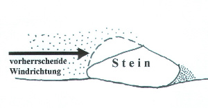
Der Sand wirkt am Gesteinsstück als Schleifmittel. Die der vorherrschenden Windrichtung zugewandte Seite (Luv-Seite) wird abgeschliffen und geglättet während die dem Wind abgewandte Seite (Lee-Seite) unverändert bleibt. Es entstehen mehr oder weniger scharfe Kanten. Mehrere Kanten entstehen, wenn der Stein im Laufe des Prozesses ein- oder mehrfach seine Lage verändert. Ebenfalls kann der Wind seine Richtung ändern.
Bitte beantwortet folgende Fragen:
1. Nenne und beschreibe das Aussehen der Findlinge mit den Nummern 12, 15 und 21! Zu welchen Gesteinsklassen gehören sie?
2. Welcher dieser drei Steine zeigt Gletscherschrammen?
3. Nenne mindestens 2 Nummern von Findlingen, welche die Form eines Windkanters haben!
4. Nenne mindestens 3 urzeitliche Tiere, welche am Uferweg zu sehen sind!
5. Freiwillig: Füge ein Foto von dir/deinem GPS im Geopark deinem Log bei!
Die korrekten Antworten gelten dann als Logbedingung! Schickt eine Mail mit euren Antworten an uns! Nach dem Absenden der Antworten könnt ihr gleich loggen. Falls etwas nicht in Ordnung ist, melden wir uns. Ihr braucht nicht unsere Logfreigabe abwarten! Wir wünschen euch viel Spaß bei dieser geologischen Entdeckungsreise!

English
You find yourself here in the rock garden of Moryń, a part of the Geopark Moryń. This is a partner project of the Geopark glacial land on the edge or in Germany. Near the stones is located a wonderful riverside path with prehistoric animals to look at and touch.
15 to 20 thousand years ago, during the last ice age, the ice of the glaciers have brought many boulders in the vicinity Moryń. They come from different regions of Scandinavia and the Baltic Sea Region. As a testimony of Pleistocene glacial movements some of the stones have glacial scratches. Among them are understood furrows on the surface of rocks or boulders. They are the result of the interplay of the glaciers and rocks carried and the load of the ice. In this rockery 35 boulders were collected. They are witnesses of the geological history of wealth. Among the exhibits there are boulders 11 igneous rocks, 16 metamorphic rocks and 8 sedimentary rocks.

After their formation a distinction 3 rock classes:
Igneous rocks
Igneous or magmatic rocks are, by cooling from a magma from the place its formation in the mantle or in the deep crust rises, resulting rocks. After the depth of their solidification a distinction between plutonic rocks, the cool below of some 100 m, and volcanic rocks, the quiet, or - if the magma is rich in gases - explosive leak to the surface.
Metamorphic rocks
Metamorphic rocks are igneous, sedimentary or metamorphic by the dynamic influence of temperature and pressure converted rocks origin. This process changes the texture of the parent rock and/or the mineral composition are connected. The reason for the metamorphosis of rocks is the pursuit of the mineral constituents of the parent material for a physico-chemical equilibrium, is fit prevailing to the ambient conditions. The origin of rock-building minerals are unstable by changing pressure and temperature conditions. As a result, there is mineral transformations or new building in the rock; strong enough to cope with the new conditions of the environment.
Sedimentary rocks
The starting materials of sedimentary rocks can be either mineral-rich solutions relics or fragments of organisms as well as by previous weathering crushed rock material; where the weathered rock material may be igneous, metamorphic or sedimentary origin sedimentary rocks are formed at the surface of the sea, in secluded shallow-water and coastal areas, or in estuaries - depending on where the various loose sediments transported by water as a solution or suspension of ice or wind, and deposited continental and marine were - hence the term sediment.
In this rock garden you can also see the so-called ventifacts, which are distinguished by their specific form:
The ventifacts belong, like the boulders and moraines to the legacies of the ice age in our country. As the name suggests, the wind will affect the shape of the stones. There are rocks which have been transported by the wind to the characteristic sand-like keel shapes. Ventifacts occur almost exclusively in low vegetation and sand-laden areas in advance of the glaciers and in deserts. They are in the Polish and North German moraine, a cold desert or cold steppes were during the ice ages (Saale and Weichselian), very widespread. In the foothills of the melting glaciers of the wind may have blown predominantly from Glacier ago, the cooling on the ice produces a cold fall wind from the ice away. The stones have been exposed from sandy sparsely vegetated areas in advance of the glacier the icy winds with its sandy cargo will be processed mechanically by the wind or sand abrasion.
The sand acts on rock piece as an abrasive. The prevailing wind direction facing side (windward side) is ground and polished while the Wind Rear facing (leeward side) will remain unchanged. This results more or less sharp burrs and edges. Several edges arise when the stone one in the process, or multiple changes its position. Also the wind can change direction.
Please answer the following questions:
1. List and describe the appearance of the boulders with the numbers 12 , 15 and 21! Which rock classes they belong?
2. Which of these three stones showing glacier scratches?
3. Name at least 2 numbers of boulders, which have the form of a ventifact!
4. Name at least 3 prehistoric animals which can be seen at the riverside!
5. Optional: Add in a photo of you / your GPS in Geopark your log!
The correct answers are then regarded as log conditions! Send an email with your answers to us! After sending the answers you can log the same. If something is wrong, we will contact you. You need not wait for our log permission! We hope you 'll enjoy this geological expedition!
źródło/Quellen/references: wikipedia, steine-und-minerale.de, spektrum.de, fossilienjäger.de

Additional Hints
(No hints available.)