- 100m 두께의 바위층이 제주도 전체를 받치고 있음
- 120만년 이상 전에 형성됨
- 40m의 절벽으로 1.5km 구간만 노출되어 있음
- 천지연폭포 입구에서 발견됨
- 유네스코 세계지질공원 : 2010년 세계지질공원네트워크에서 인증받음
- 한국천연기념물 제195호(1968년 지정)
- 명확하게 드러난 퇴적층으로 1930년대 이후 과학계의 관심이 집중됨 (화석 기록과 정보로 과거 해수면 변동과 기후변동을 알 수 있음)
- 특히 난투수층으로 알려진 물이 스며들지 않는 퇴적층은 지하수가 유출되는 것을 막아 맑은 샘물(용천수)이라는 소중한 자연자원을 제주도에 제공함

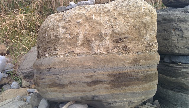
1968년 5월 23일 천연기념물 제195호로 지정된 서귀포층 패류화석산지는 서귀포시 남서 해안의 높이 약 50m 절벽에 있다. 절벽에는 두께 약 40m인 퇴적암층이 노출되어 있고 현무암으로 덮여 있으며, 주로 회색 또는 회갈색을 띤 역질사암, 사암, 이암, 셰일로 이루어져 있다.
절벽 아래에는 파도의 영향으로 긴 지름 2.5m 미만의 암괴가 낙하하여 해안을 덮었는데, 이 암괴에서도 패류화석을 많이 볼 수 있으며 쉽게 채취할 수도 있다. 여기서 관찰되는 패류화석은 대체로 현생종이지만, 대부분 제주도 근해보다 더 따뜻한 남쪽 바다에서 발견되는 것으로, 서귀포층에서 발견된 화석으로는 부족류, 복족류, 굴족류, 완족류, 극피동물 여러 종, 산호화석, 고래와 물고기 뼈, 상어 이빨 등 흔적화석이 있고, 미화석으로는 유공충 등이 있다. 이 가운데 가장 대표적인 것은 유공충 화석인데, 유공충 화석을 통해 당시의 서귀포층은 한류가 강하고 난류가 아주 약한 수심 50∼100m의 해역에서 비교적 강한 해류에 의하여 퇴적되었다는 사실을 알 수 있다. 이곳은 수심 50∼100m의 바닷속이었으나 그뒤 바다가 융기되어 점차 육지로 되었고 화산폭발이 일어나 지금의 모습으로 바뀌었을 것으로 추측하고 있다. 서귀포층은 제주도의 화산층 중에서 가장 밑에 있는 지층으로, 지질학적으로 제주도의 형성과정을 밝혀 나가는 데 귀중한 자료이다.
[로그하는 방법]
- 맨위 사진에 있는 암석 하단은 주변 해안에서 수성화산 분출로 만들어진 화쇄난류가 바다로 흘러들어 쌓인 지층들이다. 이례적으로 높은 퇴적율때문에 화석이 쌓인 지충은 평상시의 조석(밀물과 썰물)이 응회암층에 완전한 상태로 기록될 수 있었다.서귀포층은 일반적인 퇴적암보다 훨씬 자세하게 고대 환경 조건들을 기록한 화산기원 퇴적암으로의 지질학적 가치가 매우 높다. (진실/오류)
- 이 사진에 있는 돌은 캐시 좌표로부터 몇 미터 떨어져 있습니까? (OOO 미터)
- 서귀포층의 위쪽에는 다른 지층이 있습니까? 있으면 그 지층은 무엇으로 구성되어 있나요?
- 캐시존은 제주도 지하에 넓게 깔려있는 서귀포층의 일부가 솟아올라 있어 땅 위에서 서귀포층을 관찰할 수 있는 유일한 장소이다. (진실/오류)
- 이곳은 우리나라에서 유일한 신생대 제4기 초의 해성퇴적층으로 당시 동북아시아 주변의 고해양 환경을 해석하는데 중요한 지층이다. (진실/오류)
- 서퓌포층을 배경으로 당신의 GPS(또는 지오캐싱 아이템)를 찍은 사진을 로그에 올려주세요.
- 답을 제 Profile에 있는 메시지창을 이용해 제게 보내주세요. 이제 로그하셔도 됩니다. 답에 문제가 있을 경우 제가 메시지를 드리겠습니다.
(English)
- A 100-meter thick layer of rock underlying the entire island
- Over 1.2 million years old
- Only 1.5 kilometers are exposed as 40-meter-tall cliffs
- Found at the entrance of Cheonjiyeon Waterfall
- A UNESCO-mandated environmental designation: Geopark status as certified by the Global Geoparks Network (2010)
- Korean Natural Monument No. 195 (1968)
- Of strong scientific interest since the 1930s, with distinct sedimentation layers, a fossil record and information that shows past changes in sea levels and climate change
- A mostly impermeable layer (called an aquiclude) prevents groundwater from escaping, thus giving Jeju Island a precious natural resource: pure spring water (yongcheonsu)

The Seogwipo Formation is the old marine sedimentary strata that was formed during the Pliocene Epoch (from 5.3 million to 2.6 million years ago). Situated in Seohong-dong (Seogwipo), the formation contains thick shell fossils formed along coastal cliffs. It is a sedimentary layer whose width amounts to 40m and which is covered by rough basalts. This layer shows heavy concentrations of shell fossils in addition to other animal fossils. It was believed to have been formed approximately 2 to 3 million years ago. In subsequent years, waves helped turn it into a cliff.
Fossils found in the formation include pelecypod, Scaphopoda, brachiopod, echinoderms (such as sea urchins, sea cucumbers, and starfish), corals, whale bones, and shark teeth; microfossils include foraminifers which were unicellular animals living in the sea.
Because the formation offers valuable information on the traces of marine animals and the environment in the past, it was designated as National Monument No. 195 in 1968. In particular, it was designated as the World Geological Park by UNESCO along with Hallasan Mountain, Seongsan Ilchulbong Peak, and Manjanggul Cave on Jeju Island in October 2010.
[How to log]
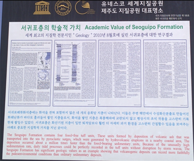
- These units(Lower part of the rock in uppermost picture) was formed by deposition of volcanic ash that was transported into the sea by pyroclastic surges, which were generated by hydrovolcanic eruptions in a nearby coastal area. The deposition occurred about a million time faster than the fossil-bearing sedimentary units. Because of the unusually high sedimentation rate, daily tidal processes could be perfectly recorded in the tuff units without disruption by storm waves. The Seoguipo Formation has significant geologic values as a axample showing that volcanogenic deposits can record more faithfully the paleoenvironmental conditions than ordinary sedimentary deposits.(True/False)
- How far is this rock from the cache coordinates? (OOO meters)
- Is there any other startum above the Seoguipo Formation? If 'yes', what consisted of that startum?
- Although the formation underpins alsmost the entirety of Jeju Island, this is the only location where it is actually exposed. (True/False)
- It is the only sedimentary formation in Korea which was formed in the early stage of 4th Cenozoic era. That is why it is considered informative in interpreting the ancient marine environment of Northeast Asia. (True/False)
- Upload the photo of your GPS(or any Geocaching item) with The Seoguipo Formation in the background!
- Please send the answers to me by message on my profile! You may log as 'Found'. If the answer is not correct, I will contact you.
(Reference)
http://english.visitkorea.or.kr
http://www.wajeju.com
Congrats to roe70 on FTF!
| I have earned GSA's highest level: |
 |