Español
Localización
Pedrosa, también conocida como Pedrosa de Tobalina, es una localidad situada en la provincia de Burgos, comunidad autónoma de Castilla y León (España), comarca de las Merindades, partido judicial de Villarcayo, ayuntamiento de Valle de Tobalina. El pueblo se divide en dos zonas características, arriba se encuentra el el pueblo desde sus inicios, y abajo (en la carretera) la parte más moderna del pueblo junto a la cascada de Pedrosa de Tobalina y el mirador
Considerada una de la siete maravillas de la provincia de Burgos. Esta cascada está formada por las aguas del río Jerea y ubicada entre Pedrosa de Tobalina y La Orden. Con más de 12 metros de altura y 100 metros de longitud, es uno de los lugares naturales de Burgos más visitados durante todo el año, aunque en invierno cobra vida propia
Geomorfologia
Las cascadas se forman cuando aparece un cambio de la litología (el tipo de roca) a lo largo del curso del río, que resulta en una erosión diferencial. Cuando el tipo de roca del canal del río cambiade una roca resistente a la una menos resistentes (por ejemplo,de granito a piedra caliza), el río erosiona la roca menos resistente más rápido, lo que produce un descenso brusco de la pendiente del río con la roca resistente a estar más arriba que la roca menos resistente. A medida que el río fluye sobre la roca resistente, cae sobre la roca menos resistente, erosionando y creando una mayor diferencia de altura entre los dos tipos de roca, apareciendo la cascada.
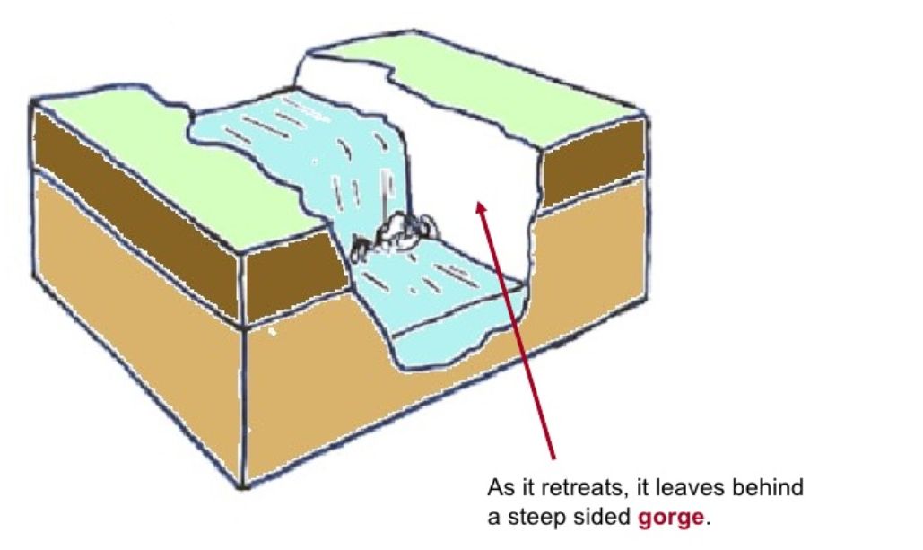
Cuando el agua fluye sobre la cascada que crea una piscina de inmersión en su base y el golpe de la caída del agua socava la roca mas resistente. La roca no soportada es llamada roca de cubierta y con el tiempo se hunde en la piscina profunda provocando que la cascada se retire aguas arriba.
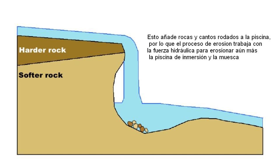
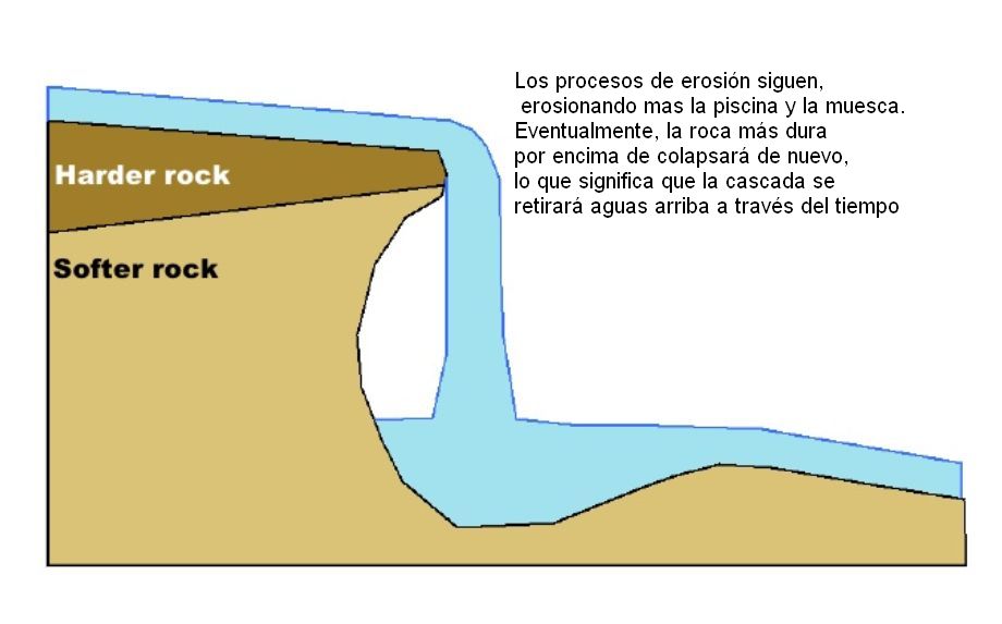
Durante miles de años, el colapso repetido de la roca de cubierta y el retroceso de la cascada generan un desfiladero de recesión.
Para registrar este earthcache, enviame um correo eletrónico com la respuesta a las seguintes preguntas:
1) Según lo leido, desde un punto de vista geológico, ¿Cual es la causa principal de que se formen cascadas?
2) Cerca del mirador,en la piscina, puedes ver restos de gran tamaño, según lo que puedes ver en la pared, ¿Pertenece a la parte dura o blanda?
3) Cual es la altura del mirador al rio. ¿Que diferencias puedes ver entre la parte dura y la blanda de la pared ?
4) Añade una fotografia tuya en el local, u otra en la que se pueda ver algún objeto, o tu nick en un papel
-Si crees que as concluido con exito los objetivos de este Earth Cache, y me ha enviado todas las respuestas solicitadas, puede hacer el log. Luego yo comprobaré que son correctas, y si hay cualquier problema me pondre en contacto para arreglarlo.
-Logs sin respuestas enviadas previamente, seran borrados sin aviso
English.(google translate)
Location
Pedrosa, also known as Pedrosa de Tobalina, is a town in the province of Burgos, autonomous community of Castilla y Leon (Spain), lines up of Merindades, judicial party of Villarcayo, city council of Valley of Tobalina. The village is divided into two features areas above the village is from the beginning, and down (on the road) the most modern part of the village next to the waterfall Tobalina Pedrosa and the viewpoint
Considered one of the seven wonders of the province of Burgos. This waterfall is formed by the waters of the river Jerea located between Pedrosa de Tobalina and the Order. With more than 12 meters high and 100 meters long, it is one of the natural places of Burgos most visited throughout the year, although in winter comes alive
Geomorphology
Waterfalls develop when a change of lithology (rock type) takes place along the river’s course resulting in differential erosion. When the rock type of the river’s channel changes from a resistant rock to a less resistant one (e.g. granite to limestone), the river erodes the less resistant rock faster producing a sudden drop in the gradient of the river with the resistant rock being higher up than the less resistant rock. As the river flows over the resistant rock, it falls onto the less resistant rock, eroding it and creating a greater height difference between the two rock types, producing the waterfall.
When water flows over the waterfall it creates a plunge pool at its base and the splashback from the falling water undercuts the resistant rock. The unsupported rock is known as the cap rock and it eventually collapses into the plunge pool causing the waterfall to retreat upstream.
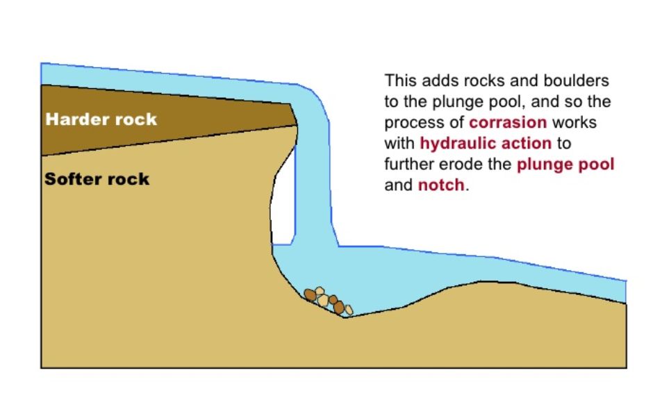
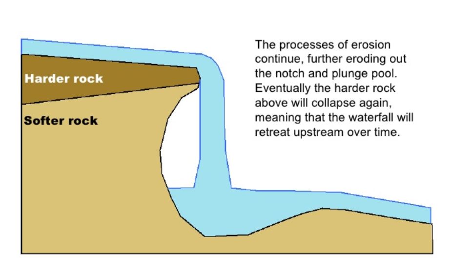
Over thousands of years, the repeated collapse of the cap rock and retreat of the waterfall produces a gorge of recession.
To log this earthcache, send me an email /message with the answer to the following questions:
1) After had read the listing, from a geological point of view, what is the main cause of waterfalls forming ?
2) Near the viewpoint, at the pool, you can see large rocks, as you can see on the wall. Belongs to the hard or soft part?
3) What is the height from the viewpoint to the river. What differences can you see between the hard part and the soft at wall?
4) Add a photo of yourself at the place, or another in which you can see an object, or your nick on a piece of paper
-If you believe you have successfully completed this Earth Cache goals and has already sent to me all the requirements as requested, Please, feel free to log it as found. Later i will verify the requirements sent and, if necessary, contact you in order to make the necessary corrections to your log.
-Logs without answers, will be deleted without notice.
Sources:
-Wikipedia
- Geography AS Notes |
