General Information and Warnings
This earthcache requires you to view a rock just across the stream at the top of a waterfall. There is a steep, unfenced drop here, please take care and don't go near the edge.
Here at Cwmorthin you will find a stunning glacial valley but geologically it can be confusing due to the vast amounts of slate mining and surface quarrying that have taken place here. The earthcaches on this trail focus on both the original glacial features of the valley, and also the interesting slate that has been exposed from underground by the workings. Always remember that the huge piles of slate you will frequently walk over and past were not placed here naturally, this is all the work of man. As you walk around, try and keep an image in your mind of how the valley would have looked before the slate was quarried.
Our earthcache trail keeps to the tracks around the old quarry and mine areas. The mines are extensive and should all be gated and locked. The mines were abandoned because they were too unsafe to work. It is not recommended to climb the spoil heaps or explore away from the paths as there could be hidden dangers, and it’s not recommended to let children or pets run off unsupervised. Also be aware that slate can have a very sharp edge and can cut very deeply, so please treat this area with the respect it requires.
Information about the Roche Moutonnée
In glaciology, a roche moutonnée (or sheepback) is a rock formation created by a glacier passing over it. The passage of glacier ice over underlying bedrock often results in 'asymmetric' erosional forms as a result of abrasion on the upstream (or "stoss") side of the rock and plucking on the downstream (or "lee") side. The diagram below explains this process. These erosional features are seen on scales of less than a metre to several hundred metres. Here at the top of the waterfall (just across the stream) is a superb example of a relatively small roche moutonnée. It can be see clearly on the far side of the falls and the shape is very obvious. At some point in the history of this valley, we can see here that a glacier passed over the top of this rock. You do not need to reach the feature, please view it safely without going near the edge of the waterfall drop.
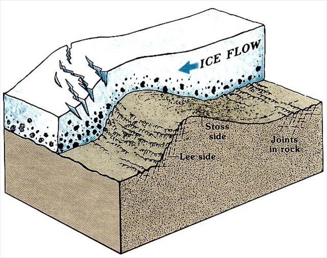
The glacier has smoothed one side of the rock to create a gentle incline - all the sides and edges have been smoothed and eroded in the direction that the glacier that once passed over it. It may be marked with glacial striations (deep cuts in the rock), further evidence of the glacial activity, (we will examine those at another location as we don’t want to encourage you to go too close to the end of the falls).
The rough and craggy down-ice (leeward) side was formed by plucking or quarrying, an erosional process initiated when ice melts slightly by pressure and seeps into cracks in the rock. When the water refreezes, the rock becomes attached to the glacier. But as the glacier continues its forward progress it subjects the stone to frost shattering, ripping pieces away from the rock formation. Studies show that the plucking of the lee side is a much more significant erosional process than the abrasion of the stoss side.
Logging Requirements (Questions to Answer)
Please e-mail me the answers to the below questions via my profile. I do read all answers and try to reply to them all; I may not reply immediately so please do not wait for a reply before posting your find. Ideally, please send your answers at the same time you submit your log, or within a few days of your visit. I do check answers have been sent for every log, if you do not send answers within a week your log may be deleted. You are not expected to have any previous geological knowledge, your best attempt at the answers is all that is required.
1. Please examine the rock and tell me which direction the smooth incline is facing, and which direction the rough craggy down-ice direction is facing.
2. Examine the rough craggy down-ice end of the rock and describe any notable details that appear to prove this side was subjected to plucking.
3. Examine the smooth incline side and note any evidence that confirms a glacier has passed over it.
4. The diagram and text above explain how a roche moutonnée can show us which direction a glacial was moving. Given your previous answers, can you tell me in which direction the glacier here was travelling?
We always like to see photographs of you and/or your GPS device with the geological features - plus this also provides additional proof of your visit, so please include one with your log if you wish.
This cache has been produced especially for the