Up on the hill above Todmorden, is a wonder of geology. Many just drive the road between Bacup and Todmorden without realising what there is. The earthcache takes you to a clough where it is possible to see geology at its best.
The moor contains Carboniferous rocks (380-250 million years old). The rocks include sandstones, gritstone, mudstones (shale), coal seams and fireclay. The Carboniferous Period is when a lot of England’s coal was formed. To access the clough, I would recommend following the Todmorden Moor Geology Trail, as it passses the base of the clough.The clough is steep sided and rough underfoot, with inclined bedrock in places.
Sandstone is a sedimentary rock, composed mainly of sand sized minerals and rock grains. Most sandstone is composed of quartz and / or feldspar because these are the most common minerals in the Earth's crust. Like sand, sandstone may be any color, but the most common colors are: tan, brown, yellow, red, grey, pink, white, and black.
Shale is a fine-grained sedimentary rock, composed of mud that is a mix of flakes of clay minerals and tiny fragments (silt -sized particles) of other minerals, especially quartz and calcite. Shale is characterized by breaks along thin laminae or parallel layering or bedding less than one centimeter in thickness, called fissility. Fissility refers to the property of rocks to split along planes of weakness into thin sheets.
Coal is a combustible black or brownish-black sedimentary rock usually occurring in rock strata in layers or veins called coal beds or coal seams. The harder forms, such as anthracite coal, can be regarded as a metamorphic rock because of later exposure to elevated temperature and pressure. Coal is composed primarily of carbon, along with variable quantities of other elements, chiefly hydrogen, sulfur, oxygen, and nitrogen. It is a fossil fuel and forms when dead plant matter is converted into peat, which in turn is converted into lignite, then sub-bituminous coal, after that bituminous coal, and lastly anthracite. The base of the Coal Measures lies at the Six Inch Mine Marine Band, which is the name of the coal seem in the clough.
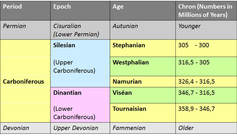
The six inch coal seem is important, as it forms the boundary between the Lower Coal Measures and the Millstone Grit series during the Carboniferous period.
The Coal Measures is a term for the coal-bearing part of the Upper Carboniferous period. The Coal Measures Group consists of the Upper Coal Measures Formation, the Middle Coal Measures Formation and the Lower Coal Measures Formation. The group records the deposition of fluvio-deltaic sediments which consists mainly of claystones, shales, silstones, sandstones and conglomerates, interstratified with the beds of coal. In most places, the Coal Measures are underlain by coarser clastic sequences known as millstone grit of Namurian Age.
Millstone Grit is the name given to any of a number of coarse-grained sandstones of Carboniferous age.
The Millstone Grit Group comprises over thirty individually named sandstones, some of regional extent, others more local in their occurrence. The oldest, and hence lowermost in the succession is the thick Pendle Grit of central Lancashire. It is succeeded by the sandstone known variously as the Brennand Grit, Warley Wise Grit and Grassington Grit. These are all of Pendleian age – the lowermost sub-stage of the Namurian. The Lower Follifoot Grit, Silver Hills Sandstone, Nottage Crag Grit, Marchup Grit, Red Scar Grit, Ward’s Stone Sandstone, Cocklett Scar Sandstones and Dure Clough Sandstones are all assigned to the following Arnsbergian sub-stage. The Kinderscoutian includes the Kinder Grit, Longnor Sandstones, Shale Grit, Todmorden Grit, Parsonage Sandstone, Heysham Harbour Sandstone, Eldroth Grit and Ellel Crag Sandstone.
The next sub-stage of the Namurian succession is the Marsdenian and it is to this that the Chatsworth Grit, Huddersfield White Rock, Holcombe Brook Grit, Greta Grits, Roaches Grit, Ashover Grit, Gorpley Grit, Pule Hill Grit, Fletcher Bank Grit, Brooksbottom Grit, Five Clouds Sandstones and Sheen Sandstones are assigned.
The closing sub-stage of the Namurian, the Yeadonian includes the Lower Haslingden Flags and the last sandstone in the entire Millstone Grit succession known as the Rough Rock.
The land surrounding Todmorden is divided roughly East and West by a system of fault lines. Two Major Faults, the Deerplay and Cliviger Faults run roughly North West to South East with smaller faults running East to West, complicating the situation and giving the 'Todmorden Smash Belt' its name. The faults provide weak zones for weathering and erosion to shape the landscape. The Pennines rose towards the end of the Carboniferous Period as the result of the collision of two tectonic plates. Erosion and weathering has exposed coal measures, sandstones, mudstones to varying degrees, but with a marked difference East and West of Todmorden.
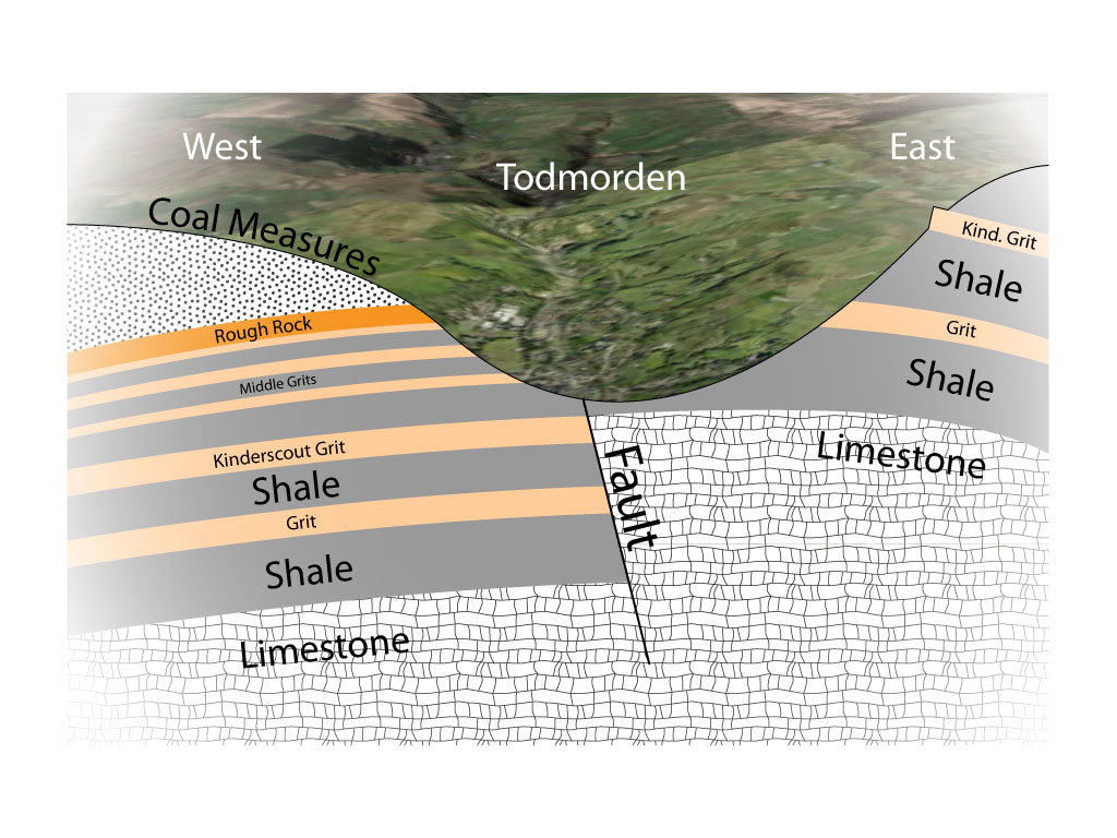
To the west of Todmorden, another powerful fault, the Deerplay Fault, runs from north west to south east, and this cut across Todmorden Moor. To the west, the strata have dropped by as much as 650 feet, and in the region of Bacup and Rossendale they become more or less horizontal. At the margin of the fault the layers have a curvature where the rocks have been dragged.
What is a Fault?
A fault is a planar fracture or discontinuity in a volume of rock, across which there has been significant displacement as a result of rock mass movement. Large faults within the Earth's crust result from the action of plate tectonic forces, with the largest forming the boundaries between the plates. Energy release associated with rapid movement on active faults is the cause of most earthquakes. A fault plane is the plane that represents the fracture surface of a fault. A fault trace or fault line is the intersection of a fault plane with the ground surface. A fault trace is also the line commonly plotted on geologic maps to represent a fault. Since faults do not usually consist of a single, clean fracture, geologists use the term fault zone when referring to the zone of complex deformation associated with the fault plane. The two sides of a non-vertical fault are known as the hanging wall and footwall. By definition, the hanging wall occurs above the fault plane and the footwall occurs below the fault.
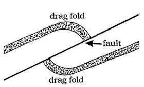
Before talking about Fault Drag, it is important to understand Folds.
A geological fold occurs when one or a stack of originally flat and planar surfaces, such as sedimentary strata, are bent or curved as a result of permanent deformation. Many folds are directly related to faults, associate with their propagation, displacement and the accommodation of strains between neighbouring faults.
Drag folds are one of the simpler types of fold. They occur in conjunction with faults, and they represent the bending of rock before it breaks.It may seem, intuitively, that the rock in a drag fold is bent by being dragged along the fault surface—hence the name—but in fact drag folding must precede the actual breakage of the rock in a fault. Like everything else, rocks prefer to bend first before they break. In most cases, the direction of folding is toward the direction of movement on the fault.
This being an earthcache, in order to log it, I ask that you answer some questions. Please send them to me, and do not include them in your log. You can send them to me by using the message facility or email, both of which can be found by looking at my profile. Don't worry, not looking for PhD standard here, remember this is friendly Yorkshire  .
.
To properly do this earthcache you need to make your way up the clough, watching out for items of geology as you go.
1. As you make your way along the clough, what is the predominant rock at first? Is it Shale, Sandstone or Coal? What is the reason for your answer?
2. Please identify the six inch coal seem, what colour is it? What is its width? Do you think it would have been viable to mine it here?
3. The rough rock is the last stage of the millstone grit series, please tell me at what angle does it lie? Is it horizontal, or tilted?
4. Can you see evidence of the rocks being affected by drag fold, in which rock is it more evident.
5. Please tell me what the shale feels and looks like.
6. Please tell me what the rough rock feels and looks like.