The Avonmore River (Irish: An Abhainn Mhór, meaning "the big river") rises in the wicklow moutains and flows in a south-easterly direction from Lough Dan, down through the the village of Annamoe, where it descends to Laragh and down through a heavily wooded valley to Rathdrum. Near Rathdrum it passes through the grounds of Avondale House, former home of Charles Stewart Parnell. A few kilometres south of Avondale it meets the Avonbeg at the Meeting of the Waters. Here the Avonmore merges with the Avonbeg to form the River Avoca, which in turn discharges into the Irish Sea at Arklow. From source to sea the river remains in East Wicklow and is approxiamtely 36km in length.
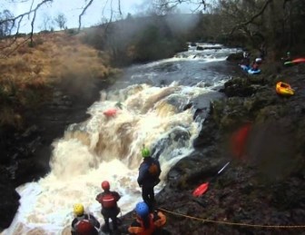
The Avonmore is very popular for fishing and gorge jumping but has a special place in the hearts of the Irish Canoeing/Kayaking community. There are many features along the grade III river which include Trooperstown Falls and Guinness Rapids, but the most famous is Jackson Falls.
Jackson Falls is a Grade IV rapid and is described as "legendary". Whilst there are other features similar to this rapid in Ireland, they are not as easily accessible. The way in which this rapid would be run varies greatly depending on water levels. You need to be an experienced paddler (Grade III standard) to run this rapid. It is also highly recommended that in all visits, you eddy in on river left just above the falls, to scout and setup rescue. Whilst it may seem bouncy and fun, there is a deep undercut at the base of the falls that can be very dangerous. The kayaking community have also named a rock 'Fernando' in the middle, of this fall, which has a taste for the damaging the nose of boats.
The Cache - Terrain
Please head the terrain rating and the attributes on the cache page and ensure you are wearing suitable footwear. No additional equipment is required, but common sense is a must. If doing this cache when there has been heavy rain, a bouyancy aid and safety gear is recommended. There is a clear path from the car park to GZ, but it is narrow & uneven in places and requires crossing two sections of river. Weather depending, this cache can be dangerous to attempt - For example, when this cache was placed it was lovely and sunny and low river levels allowed easy access to GZ, however, I have been here when the only method to cross was by kayak. An attempt at this cache is taken at your own risk and the CO takes no responsibility for any incidents that may occur.
The Cache - Difficulty
BYOP - The cache is placed about 4ft high on the edge of the river. Whilst extreme care is advised, there should be no risk of falling in the river whilst signing the log. Every attempt was made to get accurate coordinates but signal was poor so a spoiler photo has been provided - spoiler photo shows view of river from downstream.
This cache was placed under Coillte's "Leave No Trace" policy and we would ask that you respect the following:
Plan Ahead and Prepare
Travel on Durable Surfaces
Dispose of Waste Properly
Leave what you Find
Minimise Campfire Impacts
Respect Wildlife
Be Considerate of other users