General Information
A spring is any natural situation where water flows out of the ground from an underground aquifer. A spring is the result of surface water having infiltrated into the Earth's surface (over a large area known as a "recharge area"), and thus becoming part of the area's groundwater. Groundwater then travels through the underlying ground, and eventually emerges from below the surface at the location of the spring.
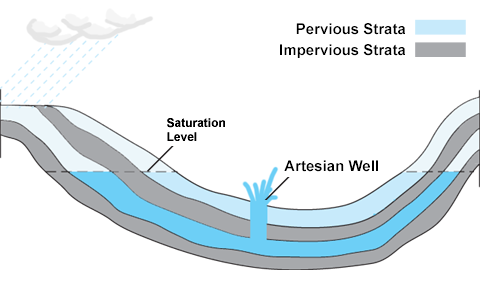
One specific type of spring is an artesian spring. Artesian springs, or the man-made version called artesian wells, are characterized by the fact that water comes out of the underlying groundwater aquifer on its own (i.e. without the need for a pump).
An artesian aquifer is a confined aquifer containing groundwater under positive pressure. This causes the water level in a well to rise to a point where hydrostatic equilibrium has been reached. An aquifer is a geologic layer of porous and pervious material such as sand and gravel, limestone, or sandstone, through which water flows and is stored. When an aquifer is confined between impervious rocks or clay, the aquifer can be put under significant positive pressure. This positive pressure creates a situation where the hydrostatic pressure may be higher in elevation than what the actual aquifer is located. If the aquifer is located close enough to ground surface, it can result in water being discharged to the surface.
Artesian wells were named after the former province of Artois in France, where many artesian wells were drilled by Carthusian monks in around the year 1126 A.D.
Spring discharge (or flow rate) is determined by the spring's recharge basin. Factors that affect how quickly a basin will recharge include: the size of the area in which groundwater is captured, the amount of precipitation, the size of capture points, and the size of the spring outlet. Water may leak into the underground system from many sources including pervious earth, sinkholes, and losing streams (streams which actually disappear into the ground).
Springs are often classified by the volume of the water they discharge. The largest springs are called "first-magnitude," defined as springs that discharge water at a rate of at least 2800 liters or 100 cubic feet (2.8 m3) of water per second. The flow at Beesley's Spring is significantly lower than a first magnitude spring. The scale for determining spring flow is as follows:
| Magnitude |
Flow (L/s) |
| 1st Magnitude |
Greater than 2800 L/s |
| 2nd Magnitude |
280 to 2800 L/s |
| 3rd Magnitude |
28 to 280 L/s |
| 4th Magnitude |
6.3 to 28 L/s |
| 5th Magnitude |
0.63 to 6.3 L/s |
| 6th Magnitude |
63 to 630 mL/s |
| 7th Magnitude |
8 to 63 mL/s |
| 8th Magnitude |
Less than 8 mL/s |
| 0 Magnitude |
no flow (sites of past/historic flow) |
Beesley's Spring Earthcache
Beesley's Spring is a natural water source that is used by a number of local and non-local residents. We've heard that people will drive from almost an hour away to fill up water jugs and tanks. The spring is a high-quality water source with low mineral content. However, as noted above, the County has recently stopped testing the quality of the water, so all users are advised to use the water at their own risk.
As noted in the "General Information" section above, an aquifer is a geologic layer of porous and pervious material. To get an idea of what the pervious material is for the Beesley's Spring aquifer, we have attached a couple of drilling reports from a few of the water wells in the area (Report #1, Report #2, Report #3). These drilling reports are public information, pulled directly off of the Province of Alberta's website: http://groundwater.alberta.ca/WaterWells/d/.
In looking at these reports, we can identify a few interesting features about the aquifer that feeds Beesley's Spring, such as:
1) The groundwater aquifer appears to be made up of a few different pervious materials, such as clayey gravel / silty gravel / sandy gravel (report #1), gravel / sand (report #2), and gray sand (report #3). Note, these three groundwater reports were done by completely different companies at different times, which may explain the variation between how one driller reports the material from within the boreholes. However, the more likely explanation is that the pervious materials within the aquifer can vary quite considerably between the locations of the boreholes.
2) The impervious layer that lies beneath the aquifer also appears to be made up of different materials, such as grey shale (report #1), clay (report #2), and gray shale / coal (report #3).
3) Despite the significant variation in the pervious and impervious materials found in the three boreholes, all three boreholes seem to indicate that the depth of the groundwater aquifer is around 12 to 15 metres. In report #1, the difference in borehole elevations between the start of the dark brown clayey gravel (pervious) and the grey shale (impervious) is approximately 12.5 metres. For report #3, the difference in borehole elevations between the start of the gray sand (pervious) and the gray shale and coal (impervious) is approximately 15 metres.
Logging Requirements
To log this earthcache, message or e-mail answers to the following questions to the cache owner to authenticate your online log. Do not post the answers online.
#1) Estimate of the rate at which the well is producing (in litres per second or millilitres per second). This can be done by bringing a container of known volume along with you and then timing how long it takes to fill that container. You will need to do this for each of the two pipes, as the flow rates are not the same for each pipe. Add these flow rates together and report your answer to us through your message / e-mail.
#2) Based on your measured flow rate, what Magnitude classification number would Beesley's Spring fall into?
#3) Using your GPSr (or using your phone with an elevation app), find the difference in elevation between the outlets of Beesley's Spring and the elevation of the top of the hill to the west along the Paradise Summer Resort access (i.e. the gravel road that takes you up the hill toward the acreages overlooking the lake to the west). What is the difference in meters? If you don't have a GPSr or an elevation app on your phone, try to estimate the difference in elevation using landmarks in the area (i.e. height of buildings or trees).
#4) (Optional) Feel free to post a photo of either your GPSr or yourself in the area.
#5) (Optional) If you choose to taste the water yourselves, please let us know if you noticed any taste to the water.
*"Found it" logs without the required email answers to questions #1 through #3 will be removed, as per Earthcache guidelines.*
Websites for additional information
https://en.wikipedia.org/wiki/Artesian_aquifer
https://en.wikipedia.org/wiki/Spring_(hydrology)